File:Dakar Rally 2011 map-en.svg
跳至導覽
跳至搜尋

此 SVG 檔案的 PNG 預覽的大小:573 × 600 像素。 其他解析度:229 × 240 像素 | 458 × 480 像素 | 734 × 768 像素 | 978 × 1,024 像素 | 1,956 × 2,048 像素 | 1,513 × 1,584 像素。
原始檔案 (SVG 檔案,表面大小:1,513 × 1,584 像素,檔案大小:3.42 MB)
說明
說明
添加單行說明來描述出檔案所代表的內容
摘要
[編輯]
| 描述 |
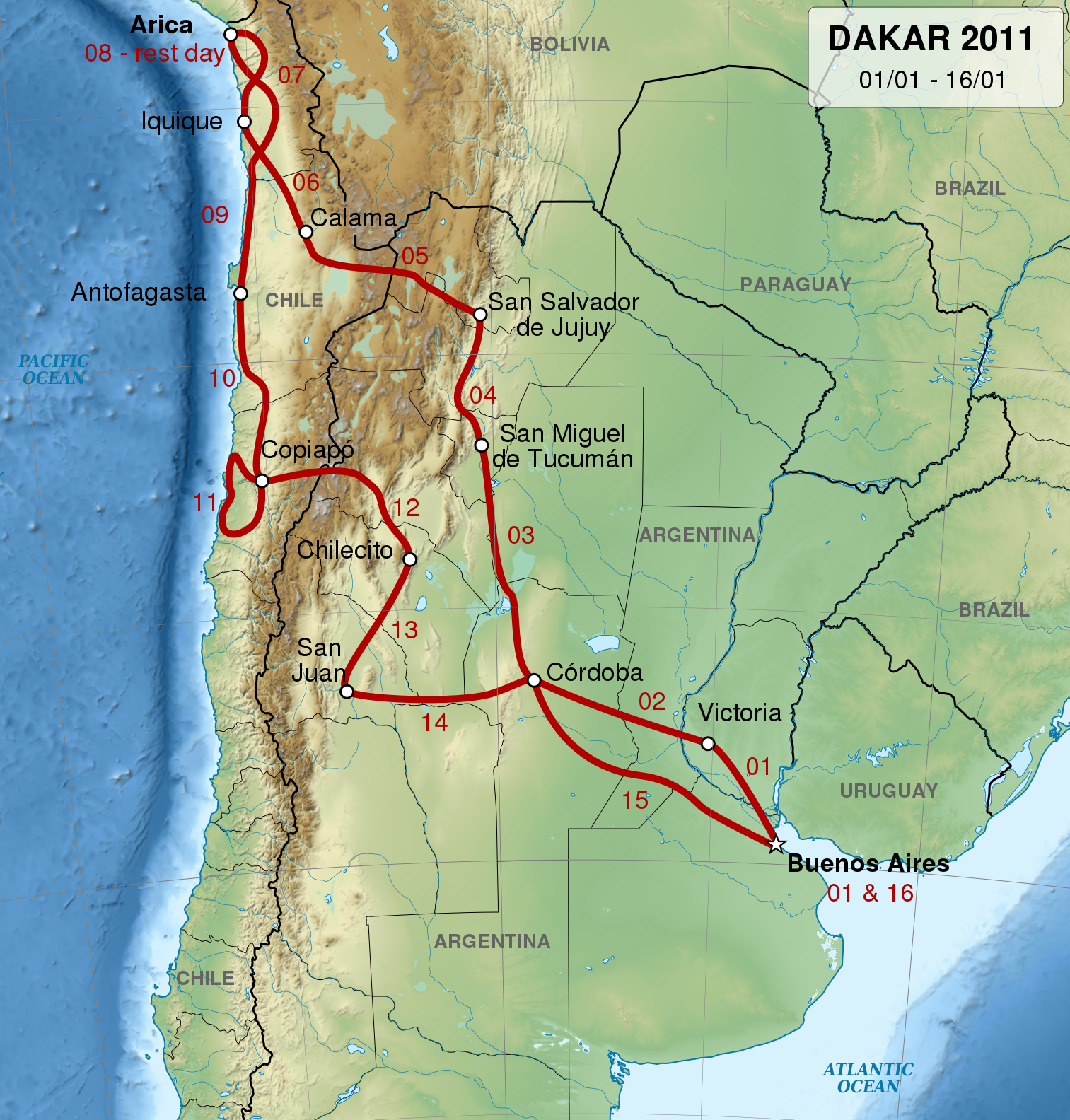
English: Map of 2011 Dakar Rally track, in English.
Français : Carte du trajet du Rallye Dakar 2011, en anglas.
Español: Mapa del circuito del Rally Dakar de 2011, en inglés.
UTM projection. |
| 日期 | |
| 來源 |
自己的作品. Sources of data:
|
| 作者 | Sémhur |
| 授權許可 (重用此檔案) |
Attribution and Share-Alike required: any use of this picture can be made as long as you credit me (Wikimedia Commons user: Sémhur) as the creator and distribute the copies and derivative works under the same license that the one indicated below. |
| 其他版本 |
Derivative works of this file: Dakar Rally 2011 map-cs.svg
[] |
| 姓名標示 (由许可协议要求) | © Sémhur / Wikimedia Commons / |
| SVG開發 | 這個SVG 檔案使用了內置文字,可以使用任何文字編輯器輕鬆翻譯。 |
| 目標地點 | | 位於此地的本圖片與其他圖片: OpenStreetMap |
|---|
授權條款
[編輯]
我,本作品的著作權持有者,決定用以下授權條款發佈本作品:
| 公共版權:本藝術作品是自由的,您可以依據自由藝術作品許可協議的條款傳播和/或修改本藝術作品。您可以在Copyleft Attitude網站或其他網站找到該許可協議的樣本。 |
This file is licensed under the Creative Commons Attribution-Share Alike Attribution-Share Alike 4.0 International, 3.0 Unported, 2.5 Generic, 2.0 Generic and 1.0 Generic license.
- 您可以自由:
- 分享 – 複製、發佈和傳播本作品
- 重新修改 – 創作演繹作品
- 惟需遵照下列條件:
- 姓名標示 – 您必須指名出正確的製作者,和提供授權條款的連結,以及表示是否有對內容上做出變更。您可以用任何合理的方式來行動,但不得以任何方式表明授權條款是對您許可或是由您所使用。
- 相同方式分享 – 如果您利用本素材進行再混合、轉換或創作,您必須基於如同原先的相同或兼容的條款,來分布您的貢獻成品。
您可以選擇您需要的授權條款。
檔案歷史
點選日期/時間以檢視該時間的檔案版本。
| 日期/時間 | 縮圖 | 尺寸 | 用戶 | 備註 | |
|---|---|---|---|---|---|
| 目前 | 2014年5月21日 (三) 20:45 | | 1,513 × 1,584(3.42 MB) | Sémhur(對話 | 貢獻) | Valid SVG |
| 2010年12月15日 (三) 19:42 |  | 1,513 × 1,584(3.42 MB) | Sémhur(對話 | 貢獻) | == {{int:filedesc}} == {{Information |Description= {{en|1=Map of 2011 Dakar Rally track, in English.}} {{fr|1=Carte du trajet du Rallye Dakar 2011, en anglas.}} {{es|1=Mapa del circuito del [[:es:Rally Da |
無法覆蓋此檔案。
檔案用途
下列2個頁面有用到此檔案:
全域檔案使用狀況
以下其他 wiki 使用了這個檔案:
- bg.wikipedia.org 的使用狀況
- ca.wikipedia.org 的使用狀況
- de.wikipedia.org 的使用狀況
- en.wikipedia.org 的使用狀況
- hu.wikipedia.org 的使用狀況
- it.wikipedia.org 的使用狀況
- nl.wikipedia.org 的使用狀況
- pl.wikipedia.org 的使用狀況
- pt.wikipedia.org 的使用狀況
- ro.wikipedia.org 的使用狀況
- ru.wikipedia.org 的使用狀況
- www.wikidata.org 的使用狀況
- zh.wikipedia.org 的使用狀況