File:De Soto National Forest, De Soto Ranger District, Mississippi - 1997 LOC 2002630466.jpg
Jump to navigation
Jump to search

Size of this preview: 450 × 599 pixels. Other resolutions: 180 × 240 pixels | 360 × 480 pixels | 576 × 768 pixels | 769 × 1,024 pixels | 1,537 × 2,048 pixels | 8,053 × 10,726 pixels.
Original file (8,053 × 10,726 pixels, file size: 11.63 MB, MIME type: image/jpeg)
Captions
Captions
Add a one-line explanation of what this file represents
Summary[edit]
| Warning | The original file is very high-resolution. It might not load properly or could cause your browser to freeze when opened at full size. |
|---|
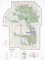
| Description |
English: "Forest Service Map." Includes location map, index to topographic sheets, index to recreation sites, and recreation information. Available also through the Library of Congress Web site as a raster image. |
||
| Title | De Soto National Forest, De Soto Ranger District, Mississippi : 1997 | ||
| Shelf ID | G3982.D45 1997 .U49 | ||
| Date | |||
| Source | https://www.loc.gov/item/2002630466/ | ||
| Author | United States. Forest Service. Southern Region; Geometronics Service Center (U.S.) | ||
| Permission (Reusing this file) |
|
||
| Other versions |
|
||
| Location | De Soto National Forest · United States · Mississippi · De Soto National Forest. | ||
| Part of | American Memory · General Maps · Catalog · Geography And Map Division | ||
| Subject | United States · Maps · Mississippi · De Soto National Forest (Miss.) · De Soto National Forest |

Licensing[edit]
| This work is from the Library of Congress. According to the library, there are no known copyright restrictions on the use of this work. |  |
File history
Click on a date/time to view the file as it appeared at that time.
| Date/Time | Thumbnail | Dimensions | User | Comment | |
|---|---|---|---|---|---|
| current | 05:52, 23 January 2019 | | 8,053 × 10,726 (11.63 MB) | Fæ (talk | contribs) | LOC Maps https://www.loc.gov/item/2002630466/ #23514 |
You cannot overwrite this file.
File usage on Commons
The following page uses this file:
File usage on other wikis
The following other wikis use this file:
- Usage on fr.wikipedia.org