File:Deadly Flooding in Libya (MODIS).jpg

Original file (1,330 × 995 pixels, file size: 132 KB, MIME type: image/jpeg)
Captions
Captions
Summary[edit]
.jpg&action=edit§ion=1)
| Description |
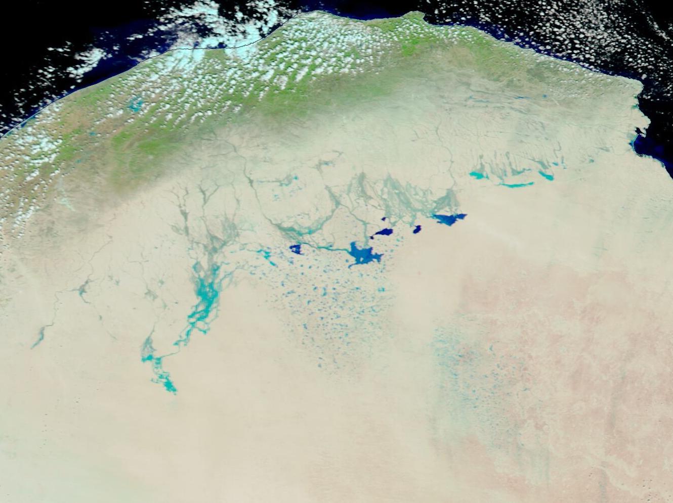
English: September 12, 2023 September 3, 2023
In early September 2023, a severe storm formed in the Mediterranean Sea. It dropped record-breaking rainfall on Greece on September 5-6, delivering 750 mm (30 in) of rain in 24 hours in Zagor—the equivalent of 18 months of rainfall—according to ReliefWeb. The same low-pressure system, which became known as Storm Daniel, produced deadly flooding in eastern Bulgaria and western Turkey on September 5, but eased by the next day. At least 26 people have been reported to have been killed in Bulgaria, Turkey, and Greece from Storm Daniel. In Greece, the storm gradually receded by the evening of September 7, but it crossed the Mediterranean Sea, making landfall in Libya on September 10 carrying maximum sustained winds of about 44-50 mph (70-80 km/h). Strong winds and severe rainfall battered northeastern Libya, including Benghazi, Tobruk, Toukra, Talmeitha, Almarj, Taknes (Al Jabal Al Akhdar), Al Owailia, Bayada, Albayda, Shahhat, Sousa and Derna, causing devastating flooding. Two dams near the city of Derna collapsed, according to media reports, after the country received a new daily rainfall record of 414.1 mm (16.3 inches). On September 12, several news outlets have reported thousands have died with many more missing in the widespread catastrophic flooding, but no firm figures have been released. On September 12, the Moderate Resolution Imaging Spectroradiometer (MODIS) on NASA’s Terra satellite acquired a false-color image of flooding across northeastern Libya. This type of image uses infrared and visible light to better visualize water, which appears in shades of blue with the deepest water looking the darkest, from land (tan) and vegetation (green). Clouds may look white or also have a blue tint. The inundated areas stretch over a distance of about 200 km (124 miles), as measured using the tools in the NASA Worldview App. To truly appreciate the stunning nature of the floods, it is helpful to compare the image acquired on September 12, 2023, with one acquired before Storm Daniel dropped a deluge over the region. To compare this image with another Terra MODIS image acquired on September 3, 2023, simply click on the dates under the image. |
||
| Date | Taken on 12 September 2023 | ||
| Source |
Deadly Flooding in Libya (direct link)
|
||
| Author | MODIS Land Rapid Response Team, NASA GSFC |
| This media is a product of the Terra mission Credit and attribution belongs to the mission team, if not already specified in the "author" row |
Licensing[edit]
.jpg&action=edit§ion=2)
| This file is in the public domain in the United States because it was solely created by NASA. NASA copyright policy states that "NASA material is not protected by copyright unless noted". (See Template:PD-USGov, NASA copyright policy page or JPL Image Use Policy.) | ||
 |
Warnings:
|
File history
Click on a date/time to view the file as it appeared at that time.
| Date/Time | Thumbnail | Dimensions | User | Comment | |
|---|---|---|---|---|---|
| current | 05:05, 13 September 2023 | | 1,330 × 995 (132 KB) | OptimusPrimeBot (talk | contribs) | #Spacemedia - Upload of http://modis.gsfc.nasa.gov/gallery/images/image09132023_250m.jpg via Commons:Spacemedia |
You cannot overwrite this file.
File usage on Commons
There are no pages that use this file.
.jpg&oldid=815468753)