File:Death Valley exit SR190 view Panamint Butt flash flood 2013.jpg

মূল ফাইল (৪,৯২৮ × ৩,২৬৪ পিক্সেল, ফাইলের আকার: ৩.৯ মেগাবাইট, এমআইএমই ধরন: image/jpeg)
ক্যাপশনসমূহ
ক্যাপশন
সারাংশ
[সম্পাদনা]| বিবরণ |
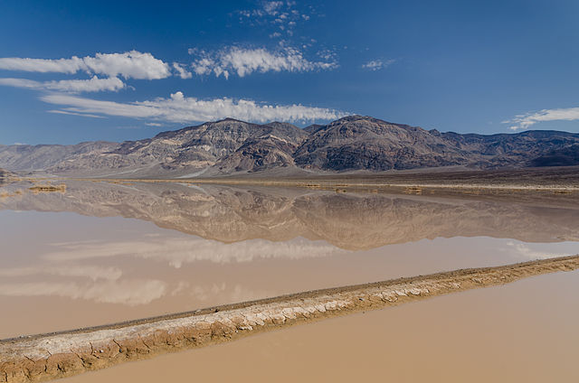
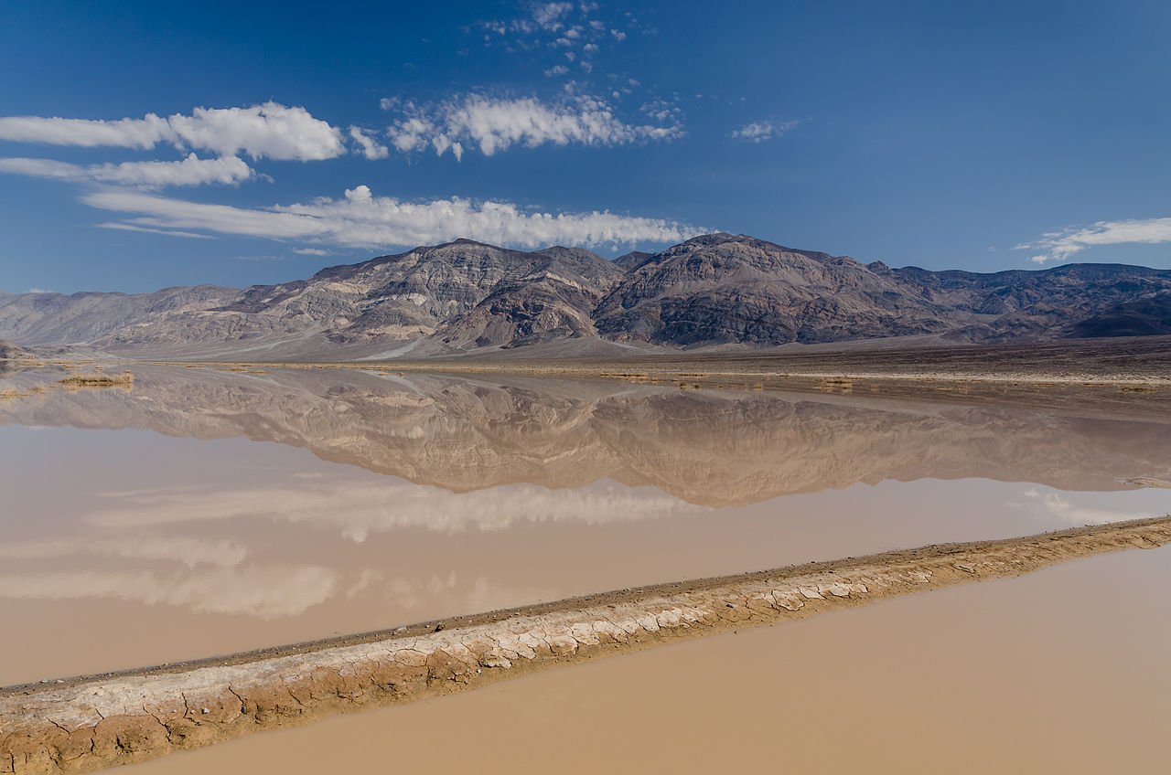
Deutsch: Blick auf Panamint Butt von SR190 mit Überschwemmungen ("Flash floods") English: View on Panamint Butt / Panamint Valley from SR190 (at the end of Death Valley) with flash floods and reflections in the water. Nederlands: Stortvloed in de Panamint Valley in het Death Valley National Park, met op de achtergrond Panamint Butt, gezien vanaf State Route 190. বাংলা: বন্যা ও জলে প্রতিচ্ছবি নিয়ে যুক্তরাষ্ট্রের ক্যালিফোর্নিয়া অঙ্গরাজ্যের স্ত্রেইট রুট ১৯০ (ডেথ ভ্যালির শেষে) থেকে পানামিন্ট বাট/ পানামিন্ট ভ্যালির দৃশ্য। |
| তারিখ | |
| উৎস | নিজের কাজ |
| লেখক | Tuxyso |
| স্বীকৃতিপ্রদান (লাইসেন্স দ্বারা প্রয়োজনীয়) | Tuxyso / Wikimedia Commons / |
| ক্যামেরার অবস্থান | | এটি এবং অন্যান্য ছবি তাদের অবস্থানের উপর: ওপেনস্ট্রিটম্যাপ |
|---|
|
এই ছবিটি উইকিমিডিয়া কমন্সে ১৩ জানুয়ারি ২০১৪-এর আজকের নির্বাচিত ছবি হিসেবে নির্বাচিত হয়েছে। নিম্নে এর ক্যাপশন রয়েছে: বাংলা: বন্যা ও জলে প্রতিচ্ছবি নিয়ে যুক্তরাষ্ট্রের ক্যালিফোর্নিয়া অঙ্গরাজ্যের স্ত্রেইট রুট ১৯০ (ডেথ ভ্যালির শেষে) থেকে পানামিন্ট বাট/ পানামিন্ট ভ্যালির দৃশ্য। অন্যান্য ভাষা:
Bosanski: Pogled na poplavljenu Panamint Butt/dolina Panamint sa SR190 (na kraju Doline smrti) sa odsjajem u vodi. Čeština: Pohled na Panamint Butt v Panamint Valley na konci Údolí smrti po bleskové povodni, Kalifornie, USA. Deutsch: Blick auf Panamint Butt mit Überschwemmungen (Flash floods) am Ende des Death Valley von der California State Route 190 English: View on Panamint Butt / Panamint Valley from SR190 (at the end of Death Valley) with flash floods and reflections in the water. Français : Vue sur Panamint Butt / Panamint Valley de SR190 (à la fin de la Vallée de la Mort) avec des crues soudaines et les reflets dans l'eau. Italiano: Panorama della Valle della Morte inondata, sullo sfondo le Panamint Mountain. Magyar: A Panamint-völgy látképe (a Death Valley végénél) és tükröződése egy hirtelen áradáskor a California State Route 190 felől Nederlands: Stortvloed in de Panamint Valley in het Death Valley National Park, met op de achtergrond Panamint Butt, gezien vanaf State Route 190. Македонски: Отсјај во поплавен предел на долината Панаминт во Калифорнија, САД. Русский: Вид на долину Панаминт из долины Смерти. বাংলা : বন্যা ও জলে প্রতিচ্ছবি নিয়ে যুক্তরাষ্ট্রের ক্যালিফোর্নিয়া অঙ্গরাজ্যের স্ত্রেইট রুট ১৯০ (ডেথ ভ্যালির শেষে) থেকে পানামিন্ট বাট/ পানামিন্ট ভ্যালির দৃশ্য। 中文: 美国死亡谷尽头的帕纳明特谷。 |
লাইসেন্স প্রদান
[সম্পাদনা]- আপনি স্বাধীনভাবে:
- বণ্টন করতে পারেন – এ কাজটি অনুলিপি, বিতরণ এবং প্রেরণ করতে পারেন
- পুনঃমিশ্রণ করতে পারেন – কাজটি অভিযোজন করতে পারেন
- নিম্নের শর্তাবলীর ভিত্তিতে:
- স্বীকৃতিপ্রদান – আপনাকে অবশ্যই যথাযথ স্বীকৃতি প্রদান করতে হবে, লাইসেন্সের একটি লিঙ্ক সরবরাহ করতে হবে এবং কোনো পরিবর্তন হয়েছে কিনা তা নির্দেশ করতে হবে। আপনি যেকোনো যুক্তিসঙ্গত পদ্ধতিতে এটি করতে পারেন। কিন্তু এমন ভাবে নয়, যাতে প্রকাশ পায় যে লাইসেন্সধারী আপনাকে বা আপনার এই ব্যবহারের জন্য অনুমোদন দিয়েছে।
- একইভাবে বণ্টন – আপনি যদি কাজটি পুনঃমিশ্রণ, রুপান্তর, বা এর ওপর ভিত্তি করে নতুন সৃষ্টিকর্ম তৈরি করেন, তবে আপনাকে অবশ্যই আপনার অবদান একই লাইসেন্স বা একই রকমের লাইসেন্সের আওতায় বিতরণ করতে হবে।
|
Dieses Foto ist vom Wikimedia Commons Nutzer Tuxyso. Achtung: Dieses Bild ist nicht gemeinfrei. Es ist zwar frei benutzbar aber gesetzlich geschützt. |
This photo was created by Wikimedia Commons user Tuxyso. Note: this image is not in the Public Domain. It is free to use but protected by law. |
||
|
|
Bitte benutzen sie nach Möglichkeit in der Bildbeschreibung: Tuxyso / Wikimedia Commons / CC-BY-SA-3.0 in unmittelbarer Nähe beim Bild oder an einer Stelle in ihrer Publikation, wo dies üblich ist. Dabei muß der Zusammenhang zwischen Bild und Urhebernennung gewahrt bleiben. |
I prefer the following credit: Tuxyso / Wikimedia Commons / CC-BY-SA-3.0 near to the photo or at a location that is common in your publication but preserving the association between image and credit. |
 |
|
Bitte lesen sie den Lizenztext gründlich, bevor sie das Bild nutzen! Wenn sie Fragen zu den Lizenzvereinbarungen haben oder mich auf eine interessante Nachnutzung hinweisen möchten, kontaktieren sie mich bitte per Mail: tuxyso@gmail.com. |
Please review the license requirements carefully before using this image. If you would like to clarify the license terms or inform me about a reuse of the image (which is always interesting for me), please contact me by email: tuxyso@gmail.com. |
||

ফাইলের ইতিহাস
যেকোনো তারিখ/সময়ে ক্লিক করে দেখুন ফাইলটি তখন কী অবস্থায় ছিল।
| তারিখ/সময় | সংক্ষেপচিত্র | মাত্রা | ব্যবহারকারী | মন্তব্য | |
|---|---|---|---|---|---|
| বর্তমান | ০৬:৪৫, ২৬ অক্টোবর ২০১৩ | | ৪,৯২৮ × ৩,২৬৪ (৩.৯ মেগাবাইট) | Tuxyso (আলোচনা | অবদান) | brightness distribution on the sky |
| ০৬:৩০, ২৬ অক্টোবর ২০১৩ |  | ৪,৯২৮ × ৩,২৬৪ (৩.৯১ মেগাবাইট) | Tuxyso (আলোচনা | অবদান) | slightly brighened, improved NR on the sky | |
| ০৮:১৮, ১২ অক্টোবর ২০১৩ |  | ৪,৯২৮ × ৩,২৬৪ (৪.৩ মেগাবাইট) | Tuxyso (আলোচনা | অবদান) | dust spots removed, selective NR on the sky | |
| ০৯:৫২, ২৯ সেপ্টেম্বর ২০১৩ |  | ৪,৯২৮ × ৩,২৬৪ (৪.৪৩ মেগাবাইট) | Tuxyso (আলোচনা | অবদান) | User created page with UploadWizard |
আপনি এই ফাইলটি প্রতিস্থাপন করতে পারবেন না।
ফাইলের ব্যবহার
নিম্নলিখিত 37টি পাতা এই ফাইল ব্যবহার করে:
- User:Miya/sandbox/FP/2013/Galleries/Table
- User:Tuxyso/Galerie
- User:Tuxyso/Galerie QI
- User:Zyephyrus/2014
- User:Zyephyrus/2014/11
- User:Аныл Озташ/Favorites
- User talk:Tuxyso/Archive 4
- User talk:Tuxyso/Archive 5
- Commons:Featured picture candidates/File:Death Valley exit SR190 view Panamint Butt flash flood 2013.jpg
- Commons:Featured picture candidates/Log/November 2013
- Commons:Featured pictures/Places/Natural/United States
- Commons:Featured pictures/chronological/2013-B
- Commons:Picture of the Year/2013/Candidates
- Commons:Picture of the Year/2013/Galleries/Table
- Commons:Picture of the Year/2013/R1/Gallery/2013-B
- Commons:Picture of the Year/2013/R1/Gallery/ALL
- Commons:Picture of the Year/2013/R1/Gallery/M11
- Commons:Picture of the Year/2013/R1/Gallery/Nature views
- Commons:Picture of the Year/2013/R1/Results/Candidates
- Commons:Picture of the Year/2013/R1/v/Death Valley exit SR190 view Panamint Butt flash flood 2013.jpg
- Commons:Quality images/Subject/Places/Natural structures/archive 2013 to 2014
- Commons:Quality images candidates/Archives October 03 2013
- Template:Potd/2014-01
- Template:Potd/2014-01-13
- Template:Potd/2014-01-13 (bn)
- Template:Potd/2014-01-13 (bs)
- Template:Potd/2014-01-13 (cs)
- Template:Potd/2014-01-13 (de)
- Template:Potd/2014-01-13 (en)
- Template:Potd/2014-01-13 (fr)
- Template:Potd/2014-01-13 (hu)
- Template:Potd/2014-01-13 (it)
- Template:Potd/2014-01-13 (mk)
- Template:Potd/2014-01-13 (nl)
- Template:Potd/2014-01-13 (ru)
- Template:Potd/2014-01-13 (zh-hans)
- Template:Potd/2014-01 (zh-hans)
ফাইলের বৈশ্বিক ব্যবহার
নিচের অন্যান্য উইকিগুলো এই ফাইলটি ব্যবহার করে:
- be-tarask.wikipedia.org-এ ব্যবহার
- bn.wikipedia.org-এ ব্যবহার
- crh.wikipedia.org-এ ব্যবহার
- cv.wikipedia.org-এ ব্যবহার
- da.wikipedia.org-এ ব্যবহার
- en.wikipedia.org-এ ব্যবহার
- hu.wikipedia.org-এ ব্যবহার
- it.wikipedia.org-এ ব্যবহার
- ka.wikipedia.org-এ ব্যবহার
- ko.wikipedia.org-এ ব্যবহার
- krc.wikipedia.org-এ ব্যবহার
- lbe.wikipedia.org-এ ব্যবহার
- nl.wikipedia.org-এ ব্যবহার
- os.wikipedia.org-এ ব্যবহার
- pt.wikipedia.org-এ ব্যবহার
- ru.wikipedia.org-এ ব্যবহার
- ru.wikinews.org-এ ব্যবহার
- sah.wikipedia.org-এ ব্যবহার
- tt.wikipedia.org-এ ব্যবহার
- uk.wikipedia.org-এ ব্যবহার
- vi.wikipedia.org-এ ব্যবহার
- xal.wikipedia.org-এ ব্যবহার
- zh.wikipedia.org-এ ব্যবহার