File:Debris-GEO1280.jpg
跳转到导航
跳转到搜索

本预览的尺寸:750 × 600像素。 其他分辨率:300 × 240像素 | 600 × 480像素 | 960 × 768像素 | 1,280 × 1,024像素。
原始文件 (1,280 × 1,024像素,文件大小:125 KB,MIME类型:image/jpeg)
说明
说明
添加一行文字以描述该文件所表现的内容
Data Comprised from a computer, showing all of the debris orbiting our atmosphere
| 描述 |
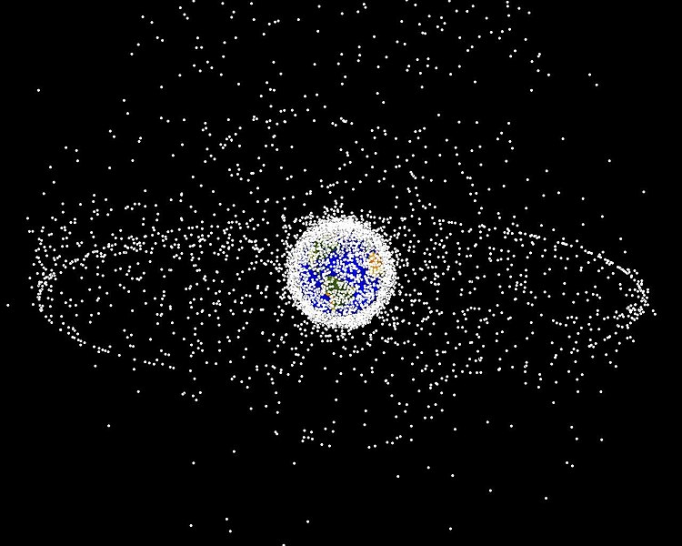
English: Debris plot by NASA.
A computer-generated image of objects in Earth orbit that are currently being tracked. Approximately 95% of the objects in this illustration are orbital debris, i.e., not functional satellites. The dots represent the current location of each item. The orbital debris dots are scaled according to the image size of the graphic to optimize their visibility and are not scaled to Earth. The image provides a good visualization of where the greatest orbital debris populations exist. This image is generated from a distant oblique vantage point to provide a good view of the object population in the geosynchronous region (around 35,785 km altitude). Note the larger population of objects over the northern hemisphere is due mostly to Russian objects in high-inclination, high-eccentricity orbits. |
|||||
| 来源 | NASA Orbital Debris Program Office, photo gallery | |||||
| 作者 | NASA image | |||||
| 授权 (二次使用本文件) |
|


文件历史
点击某个日期/时间查看对应时刻的文件。
| 日期/时间 | 缩略图 | 大小 | 用户 | 备注 | |
|---|---|---|---|---|---|
| 当前 | 2005年2月1日 (二) 16:45 | | 1,280 × 1,024(125 KB) | Srbauer(留言 | 贡献) | debris plot by NASA |
您不可以覆盖此文件。
文件用途
以下3个页面使用本文件:
全域文件用途
以下其他wiki使用此文件:
- af.wikipedia.org上的用途
- an.wikipedia.org上的用途
- ar.wikipedia.org上的用途
- az.wikipedia.org上的用途
- be-tarask.wikipedia.org上的用途
- be.wikipedia.org上的用途
- bn.wikipedia.org上的用途
- ca.wikipedia.org上的用途
- cs.wikipedia.org上的用途
- da.wikipedia.org上的用途
- de.wikipedia.org上的用途
- de.wiktionary.org上的用途
- el.wikipedia.org上的用途
- en.wikipedia.org上的用途
- Earth
- International Space Station
- Geosynchronous orbit
- Geostationary orbit
- Envisat
- Outer space
- Talk:Geostationary orbit
- Planetes
- Kessler syndrome
- Portal:Outer space
- Spacecraft cemetery
- Catcher's Mitt
- Human presence in space
- User talk:Penyulap/staticEnglish
- Space Surveillance Telescope
- User:Ginnybarnes/Spacecraft cemetery
- Portal:World
- User:FreshYoMama/TWA/Earth
- User:FreshYoMama/TWA/Earth/2
- User:Mumuhuohuo
- Draft:Space Congestion
- en.wikinews.org上的用途
- eo.wikipedia.org上的用途
- es.wikipedia.org上的用途
查看本文件的更多全域用途。