File:Decolonization - World In 1945 en.svg

原始文件 (SVG文件,尺寸为1,421 × 816像素,文件大小:802 KB)
说明
说明
摘要[编辑]
| 描述 |
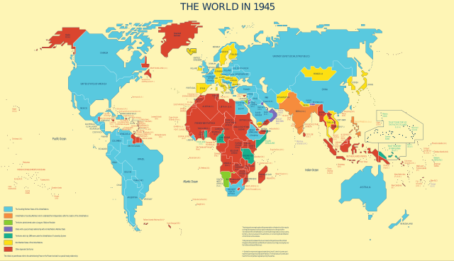
English: Map was used to show the progress of the UN's decolonization efforts.
Derivative work based on UN Map No. 4135 Rev. 3, updated in May 2010 by UN Department of Field Support, Cartographic Section Taken from the UN's decolonization website. Only modification was a conversion to SVG and per UN license, removal of reference information from the map. In fulfillment of a Wikipedia Graphics Lab: Map Workshop request by User:Gryffindor, referencing a photo taken by User:Deror_avi at the UN building.English: The founding Member States of the UN English: UN founding Members which celebrated their independence after the creation of the UN English: Territories administered under a League of Nations Mandate English: States with a special treaty relationship with a UN Member State English: Territories which by 1949 were under the UN Trusteeship System English: Non-Member States of the UN English: Other dependent territories |
|||
| 日期 | 未知日期, last update in May 2010 | |||
| 来源 | The United Nations and Decolonization | |||
| 作者 | United Nations Department of Field Support, Cartographic Section | |||
| 授权 (二次使用本文件) |
|

文件历史
点击某个日期/时间查看对应时刻的文件。
| 日期/时间 | 缩略图 | 大小 | 用户 | 备注 | |
|---|---|---|---|---|---|
| 当前 | 2022年7月9日 (六) 01:31 | | 1,421 × 816(802 KB) | Kwamikagami(留言 | 贡献) | Reverted to version as of 22:10, 21 May 2012 (UTC) |
| 2022年7月9日 (六) 01:29 |  | 1,421 × 816(802 KB) | Kwamikagami(留言 | 贡献) | official UN blue, #009edb | |
| 2012年5月21日 (一) 22:10 |  | 1,421 × 816(802 KB) | 25or6to4(留言 | 贡献) | updated to approved font, should fix location issues | |
| 2011年5月12日 (四) 20:24 |  | 1,421 × 816(533 KB) | Ras67(留言 | 贡献) | frame removed | |
| 2010年9月7日 (二) 22:15 |  | 1,438 × 832(497 KB) | Gringer(留言 | 贡献) | Arial font, some unnecessary styles removed | |
| 2010年9月7日 (二) 04:51 |  | 1,438 × 832(4.38 MB) | Lesqual(留言 | 贡献) | Uploaded with fonts converted to paths so that WP can render text properly until it gets a better RSVG implementation - if you need to modify, use previous revision. | |
| 2010年9月7日 (二) 04:32 |  | 1,438 × 832(616 KB) | Lesqual(留言 | 贡献) | {{Information |Description={{en|1=Map was used to show the progress of the UN's decolonization efforts. Derivative work based on UN Map No. 4135 Rev. 3, updated in May 2010 by UN Department of Field Support, Cartographic Section Taken from the UN's deco |
您不可以覆盖此文件。
文件用途
全域文件用途
以下其他wiki使用此文件:
- bg.wikipedia.org上的用途
- bn.wikipedia.org上的用途
- ca.wikipedia.org上的用途
- cs.wikipedia.org上的用途
- cy.wikipedia.org上的用途
- de.wikipedia.org上的用途
- en.wikipedia.org上的用途
- es.wikipedia.org上的用途
- fa.wikipedia.org上的用途
- fi.wikipedia.org上的用途
- fr.wikipedia.org上的用途
- id.wikipedia.org上的用途
- ko.wikipedia.org上的用途
- ms.wikipedia.org上的用途
- ne.wikipedia.org上的用途
- nl.wikipedia.org上的用途
- no.wikipedia.org上的用途
- pa.wikipedia.org上的用途
- pt.wikipedia.org上的用途
- sh.wikipedia.org上的用途
- sk.wikipedia.org上的用途
- so.wikipedia.org上的用途
- sv.wikipedia.org上的用途
- ta.wikipedia.org上的用途
- th.wikipedia.org上的用途
- uz.wikipedia.org上的用途
- vi.wikipedia.org上的用途
- zh.wikipedia.org上的用途
元数据
- Derivatives of UN maps
- United Nations Trusteeship Council
- Maps of the United Nations system
- Decolonization
- 1945 in international relations
- Maps of the world in the 1940s
- SVG maps of the world showing history
- Maps showing the history of colonies
- SVG political maps of the world
- 2010s maps of the world
- English-language SVG maps showing history
- Maps showing 1945