File:Diagrama MMMD.gif
Jump to navigation
Jump to search
No higher resolution available.
Diagrama_MMMD.gif (250 × 395 pixels, file size: 14 KB, MIME type: image/gif)
Captions
Captions
Add a one-line explanation of what this file represents
Summary
[edit]
| Camera location | | View this and other nearby images on: OpenStreetMap |
|---|
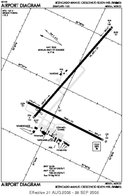
| Description |
Español: Diagrama de Aeropuerto Internacional Manuel Crescencio Rejón, de la ciudad de Mérida, Yucatán, México English: Diagram of the "Manuel Crescencio Rejón" Internacional Airport, from Mérida, Yucatán, México |
| Date | |
| Source | Federal Administration Aviation |
| Author | Federal Administration Aviation |
Licensing
[edit]
This image or file is a work of a Federal Aviation Administration employee, taken or made as part of that person's official duties. As a work of the U.S. federal government, the image is in the public domain in the United States.
|
 |
File history
Click on a date/time to view the file as it appeared at that time.
| Date/Time | Thumbnail | Dimensions | User | Comment | |
|---|---|---|---|---|---|
| current | 07:45, 29 January 2012 | | 250 × 395 (14 KB) | Jmagno1998 (talk | contribs) |
You cannot overwrite this file.
File usage on Commons
The following page uses this file:
File usage on other wikis
The following other wikis use this file:
- Usage on en.wikipedia.org
- Usage on es.wikipedia.org
- Usage on id.wikipedia.org
- Usage on pl.wikipedia.org
- Usage on pt.wikipedia.org
- Usage on vi.wikipedia.org