File:Didemnum.jpg
Jump to navigation
Jump to search

Size of this preview: 393 × 599 pixels. Other resolutions: 157 × 240 pixels | 525 × 800 pixels.
Original file (525 × 800 pixels, file size: 166 KB, MIME type: image/jpeg)
Captions
Captions
Add a one-line explanation of what this file represents
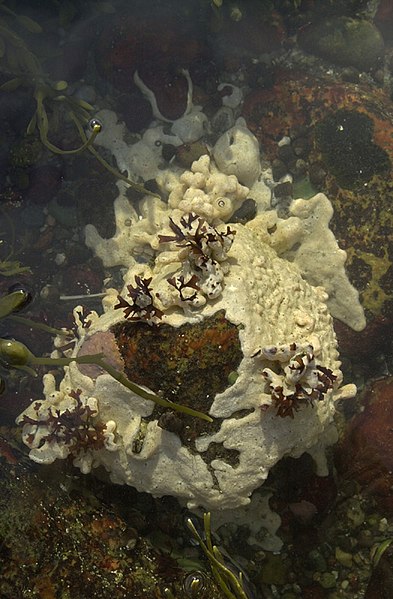
| Description | Image DB_STP_DSC0146 Tunicate colonies of Didemnum sp. encrusting a boulder and overgrowing dark red algae and pink calcareous algae. Sandwich tide pool (41 deg 46.42 min N lat, 70 deg 29.30 min W lon). Water depth, intertidal range to 11 feet (3.4 m). Collected at low tide. December 4, 2003. Collectors: Mary Carman and Page Valentine. Photo credit: Dann Blackwood, U.S. Geological Survey. |
| Date | |
| Source | https://woodshole.er.usgs.gov/project-pages/stellwagen/didemnum/htm/page3.htm |
| Author | U.S. Geological Survey/photo by Dann Blackwood (USGS) |
| Permission (Reusing this file) |
U.S. public domain |
| Camera location | | View this and other nearby images on: OpenStreetMap |
|---|
This image is in the public domain in the United States because it only contains materials that originally came from the United States Geological Survey, an agency of the United States Department of the Interior. For more information, see the official USGS copyright policy.
|
File history
Click on a date/time to view the file as it appeared at that time.
| Date/Time | Thumbnail | Dimensions | User | Comment | |
|---|---|---|---|---|---|
| current | 18:47, 13 March 2008 | | 525 × 800 (166 KB) | WarBaCoN (talk | contribs) | {{Information |Description=Image DB_STP_DSC0146 Tunicate colonies of Didemnum sp. encrusting a boulder and overgrowing dark red algae and pink calcareous algae. Sandwich tide pool (41 deg 46.42 min N lat, 70 deg 29.30 min W lon). Water depth, intertidal r |
You cannot overwrite this file.
File usage on Commons
The following 3 pages use this file:
File usage on other wikis
The following other wikis use this file:
- Usage on ca.wikipedia.org
- Usage on ceb.wikipedia.org
- Usage on en.wikipedia.org
- Usage on es.wikipedia.org
- Usage on fr.wikipedia.org
- Usage on ko.wikipedia.org
- Usage on nl.wikipedia.org
- Usage on sv.wikipedia.org
- Usage on tr.wikipedia.org
- Usage on war.wikipedia.org
- Usage on www.wikidata.org
- Usage on zh.wikipedia.org