File:Divisions of the Sudetes.svg
跳至導覽
跳至搜尋

此 SVG 檔案的 PNG 預覽的大小:800 × 503 像素。 其他解析度:320 × 201 像素 | 640 × 402 像素 | 1,024 × 644 像素 | 1,280 × 805 像素 | 2,560 × 1,610 像素 | 1,576 × 991 像素。
原始檔案 (SVG 檔案,表面大小:1,576 × 991 像素,檔案大小:195 KB)
說明
說明
添加單行說明來描述出檔案所代表的內容
摘要
[編輯]| 描述 |
English: Divisions of the Sudetes Deutsch: Naturräumliche Gliederung der Sudeten Polski: Sudety Čeština: Krkonošsko-jesenická subprovincie (This article is just about the Czech Part of the Sudetes) |
| 日期 | |
| 來源 |
自己的作品 本檔案衍生自: Sudeten.png |
| 作者 | Pavouk (colors and revised legend: W like wiki) |
| 其他版本 |
|

Legend
[編輯]Original legend copied from de:Sudeten#Gliederung (copy date was 2009)
Notes:
- ↑ a b c d The Czech names for Nr. 21 (Góry Kamienne), 22 (Lubavská brána), 25 (Broumovská kotlina) and 26 (Stolové hory) are names for landscapes. The Czech parts of these landscapes are geomorphologicaly put together under different names in one region called cs:Broumovská vrchovina IVB-1 (pl:Broumovská vrchovina, de:Braunauer Bergland).
- Region is part of these countries
- The numbers behind the polish names in the table are polish region numbers. (The underlining of some numbers meaning nothing but to separate them visually: 332.2 and its subdevisions from 332.3 in Western Sudetes and 332.1 and its subdevisions from 332.4 and 332.5 in Central Sudetes.)
For a map of the polish part of the sudetes with region numbers see: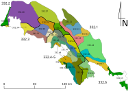 Sudety podzial.svg or with elevations
  Polish Regiony Southwest with Sudetes.png
 - for more details see also:
- pl:Sudety#Podział Sudetów (łącznie z przedgórzem) – Division of the Sudetes (including the foothills)
- cs:Krkonošsko-jesenická subprovincie – Czech name of the area


授權條款
[編輯]
我,本作品的著作權持有者,決定用以下授權條款發佈本作品:
此檔案採用創用CC 姓名標示-相同方式分享 3.0 未在地化版本授權條款。
- 您可以自由:
- 分享 – 複製、發佈和傳播本作品
- 重新修改 – 創作演繹作品
- 惟需遵照下列條件:
- 姓名標示 – 您必須指名出正確的製作者,和提供授權條款的連結,以及表示是否有對內容上做出變更。您可以用任何合理的方式來行動,但不得以任何方式表明授權條款是對您許可或是由您所使用。
- 相同方式分享 – 如果您利用本素材進行再混合、轉換或創作,您必須基於如同原先的相同或兼容的條款,來分布您的貢獻成品。
檔案歷史
點選日期/時間以檢視該時間的檔案版本。
| 日期/時間 | 縮圖 | 尺寸 | 使用者 | 備註 | |
|---|---|---|---|---|---|
| 目前 | 2021年1月8日 (五) 00:24 | | 1,576 × 991(195 KB) | W like wiki(留言 | 貢獻) | 33a switched with 33b |
| 2021年1月8日 (五) 00:19 |  | 1,576 × 991(195 KB) | W like wiki(留言 | 貢獻) | #33: Góry Bystrzyckie and Góry Orlickie "a bit" separated, in #4: border of Kotlina Żytawska | |
| 2020年12月24日 (四) 03:28 |  | 1,576 × 991(193 KB) | W like wiki(留言 | 貢獻) | blue borders, blue states | |
| 2020年12月24日 (四) 03:21 |  | 1,576 × 991(193 KB) | W like wiki(留言 | 貢獻) | corr mistake at #22 | |
| 2020年12月24日 (四) 03:02 |  | 1,576 × 991(193 KB) | W like wiki(留言 | 貢獻) | subregions in separate colors to show better the connections across the fat blue state borders | |
| 2013年9月15日 (日) 16:38 |  | 1,576 × 991(156 KB) | Pavouk(留言 | 貢獻) | User created page with UploadWizard |
無法覆蓋此檔案。
檔案用途
下列7個頁面有用到此檔案:
全域檔案使用狀況
以下其他 wiki 使用了這個檔案:
- bs.wikipedia.org 的使用狀況
- cs.wikipedia.org 的使用狀況
- da.wikipedia.org 的使用狀況
- de.wikipedia.org 的使用狀況
- de.wikibooks.org 的使用狀況
- de.wikiversity.org 的使用狀況
- de.wikivoyage.org 的使用狀況
- de.wiktionary.org 的使用狀況
- el.wikipedia.org 的使用狀況
- en.wikipedia.org 的使用狀況
- en.wikivoyage.org 的使用狀況
- en.wiktionary.org 的使用狀況
- eo.wikipedia.org 的使用狀況
- es.wikipedia.org 的使用狀況
- fa.wikipedia.org 的使用狀況
- fi.wikipedia.org 的使用狀況
- fr.wikipedia.org 的使用狀況
- fy.wikipedia.org 的使用狀況
- hsb.wikipedia.org 的使用狀況
- incubator.wikimedia.org 的使用狀況
- is.wikipedia.org 的使用狀況
- it.wikipedia.org 的使用狀況
- ko.wikipedia.org 的使用狀況
- lt.wikipedia.org 的使用狀況
- mk.wikipedia.org 的使用狀況
- no.wikipedia.org 的使用狀況
檢視此檔案的更多全域使用狀況。
詮釋資料
分類:
- Maps of the Sudetes
- Western Sudetes
- Šluknovská pahorkatina
- Žitavská pánev
- Lusatian Mountains
- Zittau Mountains
- Frýdlantská pahorkatina
- Pogórze Izerskie
- Jizera Mountains
- Ještědsko-kozákovský hřbet
- Pogórze Kaczawskie
- Góry Kaczawskie
- Rudawy Janowickie
- Krkonoše
- Krkonošské podhůří
- Central Sudetes
- Przedgórze Sudeckie
- Masyw Ślęży
- Góry Wałbrzyskie
- Góry Kamienne
- Vraní hory
- Góry Sowie
- Obniżenie Ścinawki
- Góry Stołowe
- Wzgórza Niemczańsko-Strzelińskie
- Góry Bardzkie
- Kotlina Kłodzka
- Orlické hory
- Góry Bystrzyckie
- Podorlická pahorkatina
- Eastern Sudetes
- Góry Złote
- Masyw Śnieżnika
- Góry Opawskie
- Hrubý Jeseník
- Hanušovická vrchovina
- Zábřežská vrchovina
- Nízký Jeseník