File:Doctrine and Guidance Brigade, מפת קרבות מלחמת העצמאות 03-Safad (FL169790473 2555522).jpg
Jump to navigation
Jump to search

Size of this preview: 800 × 564 pixels. Other resolutions: 320 × 226 pixels | 640 × 451 pixels | 1,024 × 722 pixels | 1,280 × 903 pixels | 2,560 × 1,805 pixels | 16,330 × 11,516 pixels.
Original file (16,330 × 11,516 pixels, file size: 198.63 MB, MIME type: image/jpeg)
Captions
Captions
Add a one-line explanation of what this file represents
Summary
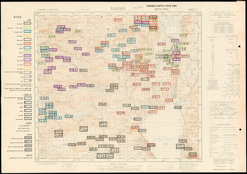
[edit]| Doctrine and Guidance Brigade: מפת קרבות מלחמת העצמאות
( |
||||||||||||||||||||||||
|---|---|---|---|---|---|---|---|---|---|---|---|---|---|---|---|---|---|---|---|---|---|---|---|---|
| Artist | ||||||||||||||||||||||||
| Title |
מפת קרבות מלחמת העצמאות |
|||||||||||||||||||||||
| Publisher |
דפוס בית המדידות הממשלתי |
|||||||||||||||||||||||
| Description |
מפת קרבות מלחמת העצמאות. כוחות קרקע.. |
|||||||||||||||||||||||
| Language | Hebrew | |||||||||||||||||||||||
| Publication date | from 1953 until 1954 (5714 AM) | |||||||||||||||||||||||
| Medium | 29 גליונות. | |||||||||||||||||||||||
| Collection |
|
|||||||||||||||||||||||
| Current location |
|
|||||||||||||||||||||||
| Place of publication | Tel Aviv | |||||||||||||||||||||||
| search Merhav catalog | Tel Aviv | |||||||||||||||||||||||
| Notes | חלק ממפות הבסיס הן של Survey of Palestine. הודפס עי מחלקת המדידות ישראל.;$a5 המפות האחרונות כוללות שטח מצרי.;$aמצורף ספר: אינדקס מפת קרבות מלחמת העצמאות -רשימת הקרבות לפי חתך גיאוגרפי. R2 54 A 2476;$aהודפסו 100 טפסים מפרסום זה.;$aלקריאה נוספת וניתוח הקרבות בהתייחסות ישירה לגליונות המפה, ראו: קרבות מלחמת העצמאות, מפות ומבצעים, משרד הבטחון, 2018. 2018 A 6005 | |||||||||||||||||||||||
| scale | 1:100,000 cm | |||||||||||||||||||||||
| IE PID | IE169790467 | |||||||||||||||||||||||
| Rosetta filename | FL169790473 | |||||||||||||||||||||||
| NNL item ID (P3959) | 990025555220205171 | |||||||||||||||||||||||
| search Merhav catalog | Hebrew, Doctrine and Guidance Brigade | |||||||||||||||||||||||
| search Merhav catalog | דפוס בית המדידות הממשלתי | |||||||||||||||||||||||
| Source/Photographer |
|
|||||||||||||||||||||||
| Other versions | ||||||||||||||||||||||||
| Jpg / Tif version |
|
|||||||||||||||||||||||

.jpg)

.jpg&action=edit§ion=1)
Licensing
[edit].jpg&action=edit§ion=2)
This work created by the United Kingdom Government is in the public domain.
This is because it is one of the following:
HMSO has declared that the expiry of Crown Copyrights applies worldwide (ref: HMSO Email Reply)
|
 |
This work was created or ordered by the State of Israel, and is in the public domain because it satisfies one of the conditions stipulated in Israel's copyright statute from 2007 (translation) regarding the State's copyrights:
|

|
[[Category:]]
File history
Click on a date/time to view the file as it appeared at that time.
| Date/Time | Thumbnail | Dimensions | User | Comment | |
|---|---|---|---|---|---|
| current | 08:41, 20 August 2023 | | 16,330 × 11,516 (198.63 MB) | Geagea (talk | contribs) | pattypan 22.03 |
You cannot overwrite this file.
File usage on Commons
The following page uses this file:
.jpg&oldid=811710071)