File:Dominica - Location Map (2013) - DMA - UNOCHA.svg

Orihinal na file (SVG na file, nominal na 250 × 250 (na) pixel, laki: 351 KB)
Captions
Captions
Buod[baguhin]
_-_DMA_-_UNOCHA.svg&action=edit§ion=1)
| Paglalarawan |
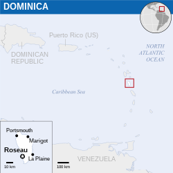
English: Locator map of Dominica. |
| Petsa | |
| Pinanggalingan |
English: Dominica Locator Map (ReliefWeb), ESRI, UNCS |
| May-akda | |
| SVG genesis |
Paglilisensiya[baguhin]
_-_DMA_-_UNOCHA.svg&action=edit§ion=2)
- Malaya kang:
- para ibahagi – para kopyahin, ipamahagi, at i-transmit ang akda
- para i-remix – para i-adapt ang akda
- Sa ilalim ng mga kondisyong ito:
- atribusyon – Dapat magbigay ka ng isang maayos na pag-credit, ibigay ang link sa lisensiya, at tukuyin kung may mga pagbabagong ginawa. Magagawa mo ito sa isang risonableng paraan, pero hindi sa paraan na para bang ineendorso ka o ng paggamit mo ng naglisensiya sa'yo.
 This map is part of a collection of 216 free country maps, created by the UN Office for the Coordination of Humanitarian Affairs (OCHA), to be used in print, web or broadcast products.
The ReliefWeb Location Maps released here are maps that highlight a country, its capital, major populated places and the surrounding regions. Attribution Requirements
Using the map without modifications: ensure that the sources and the disclaimer are below the map. Credit as follows: "Credit: OCHA". For use with alteration: remove the OCHA logo and disclaimer following any modification to the map, but keep the data sources as mentioned below the map. Credit the modified map as follows: "Based on OCHA map". You are responsible for the content of your map. We are keen to receive your feedback and hear how you used OCHA's maps. We would be grateful if you would notify us by e-mail and share your work with us. UN Disclaimer
The designations employed and the presentation of material of this map do not imply the expression of any opinion whatsoever on the part of the Secretariat of the United Nations concerning the legal status of any country, territory, city or area or of its authorities or concerning the delimitation of its frontiers or boundaries. |

|
Textual information (e.g. timestamp) once visible in the image itself has been moved into the image metadata and/or image description page. This makes the image easier to reuse and more language-neutral, and makes the text easier to process and search for. Commons discourages placing visible textual information in images. All licenses accepted on Commons permit this type of modification as a derivative work.
If attribution information were removed and the image is not public domain, replace this tag with {{Attribution metadata from licensed image}}.
|
Nakaraan ng file
Pindutin ang isang petsa/oras para makita ang file noong puntong yon.
| Petsa/Oras | Thumbnail | Sukat | Tagagamit | Komento | |
|---|---|---|---|---|---|
| ngayon | 08:47, 19 Nobyembre 2022 | | 250 × 250 (351 KB) | Pengetik-AM (usapan | ambag) | File uploaded using svgtranslate tool (https://svgtranslate.toolforge.org/). Added translation for id. |
| 11:40, 18 Pebrero 2016 |  | 250 × 250 (350 KB) | Wereldburger758 (usapan | ambag) | Resized page to drawing. Removal watermark. Validation of image. | |
| 00:16, 21 Abril 2014 |  | 254 × 254 (373 KB) | UN OCHA maps bot (usapan | ambag) | == {{int:filedesc}} == {{Information |description={{en|1=Locator map of Dominica.}} |date=2013 |source={{en|1=[http://reliefweb.int/map/dominica/dominica-location-map-2013 Dominica Locator Map (ReliefWeb)]}} |author={{en|1=[[w:en:Unit... |
Hindi mo mao-overwrite ang file na ito.
Paggamit sa file
Ginagamit ng sumusunod na pahina ang file na ito:
Pandaigdigang paggamit sa file
Ginagamit ng mga sumusunod na wiki ang file na ito:
- Paggamit sa am.wikipedia.org
- Paggamit sa bh.wikipedia.org
- Paggamit sa fa.wikipedia.org
- Paggamit sa id.wikipedia.org
- Paggamit sa mdf.wikipedia.org
- Paggamit sa my.wikipedia.org
- Paggamit sa sco.wikipedia.org
- Paggamit sa sd.wikipedia.org
- Paggamit sa te.wikipedia.org
_-_DMA_-_UNOCHA.svg&oldid=707841118)