File:Dover UK locator map.svg
ナビゲーションに移動
検索に移動

この SVG ファイルのこの PNG プレビューのサイズ: 800 × 561 ピクセル. その他の解像度: 320 × 225 ピクセル | 640 × 449 ピクセル | 1,024 × 719 ピクセル | 1,280 × 898 ピクセル | 2,560 × 1,796 ピクセル | 1,425 × 1,000 ピクセル。
元のファイル (SVG ファイル、1,425 × 1,000 ピクセル、ファイルサイズ: 1.18メガバイト)
キャプション
キャプション
このファイルの内容を1行で記述してください
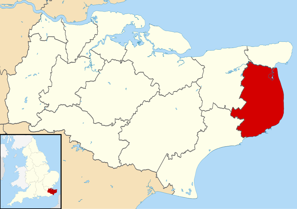
| 解説 | Equirectangular map projection on WGS 84 datum, with N/S stretched 160% |
| 日付 | |
| 原典 |
|
| 作者 | Nilfanion, created using Ordnance Survey data |
| 許可 (ファイルの再利用) |
このファイルはクリエイティブ・コモンズ 表示-継承 3.0 非移植ライセンスのもとに利用を許諾されています。 帰属: Contains Ordnance Survey data © Crown copyright and database right
|
ファイルの履歴
過去の版のファイルを表示するには、その版の日時をクリックしてください。
| 日付と時刻 | サムネイル | 寸法 | 利用者 | コメント | |
|---|---|---|---|---|---|
| 現在の版 | 2011年8月2日 (火) 09:07 | | 1,425 × 1,000 (1.18メガバイト) | Nilfanion (トーク | 投稿記録) | {{Information |Description=Map of Kent, UK with Dover highlighted. Equirectangular map projection on WGS 84 datum, with N/S stretched 160% |Source=Ordnance Survey [https://www.ordnancesurvey.co.uk/o |
このファイルは上書きできません。
ファイルの使用状況
以下の 2 ページがこのファイルを使用しています:
グローバルなファイル使用状況
以下に挙げる他のウィキがこの画像を使っています:
- cy.wikipedia.org での使用状況
- en.wikipedia.org での使用状況
- Dover
- Sandwich, Kent
- Walmer
- Eythorne
- Dover District
- East Langdon
- Deal, Kent
- Eastry
- Drellingore
- Kingsdown, Dover
- Maxton, Kent
- Martin, Kent
- Martin Mill
- Coombe, Kent
- Ash, Dover District
- West Langdon
- Wingham, Kent
- Barfrestone
- Kearsney, Kent
- Elvington, Kent
- Capel-le-Ferne
- Richborough
- Lydden
- Whitfield, Kent
- Alkham
- Ripple, Kent
- Aylesham
- Nonington
- Marley, Dover
- Temple Ewell
- Preston-next-Wingham
- River, Kent
- Shepherdswell
- Plucks Gutter
- Template:Towns and villages in Dover district
- St Margaret's at Cliffe
- Sholden
- Tilmanstone
- Buckland, Kent
- Staple, Kent
- Great Mongeham
- User:O1ive/Dover
- Goodnestone, Dover
- Woodnesborough
- Guston, Kent
- Stourmouth
- Ashley, Kent
- Coldred
- Denton, Kent
このファイルのグローバル使用状況を表示する。