File:Drought in the Zambezi Basin (MODIS 2024-04-24).jpg

Drought_in_the_Zambezi_Basin_(MODIS_2024-04-24).jpg (732 × 545 pixels, file size: 50 KB, MIME type: image/jpeg)
Captions
Captions
Summary[edit]
.jpg&action=edit§ion=1)
| Description |
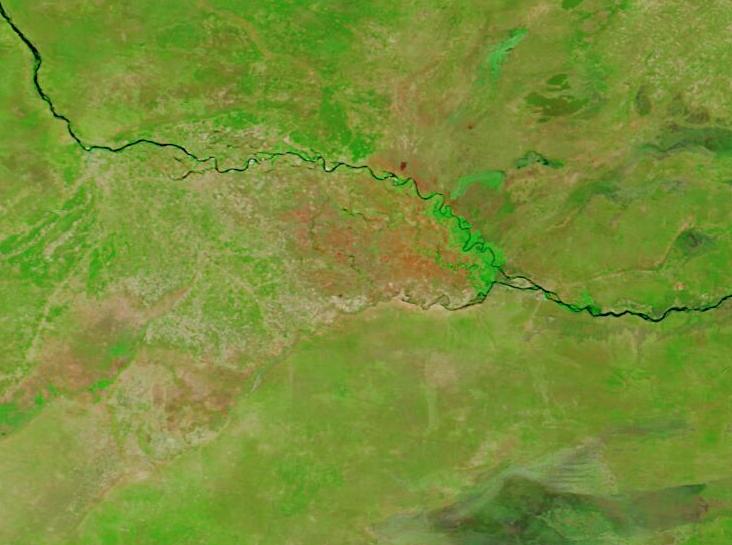
English: April 20, 2024 April 13, 2023
A prolonged dry spell in southern Africa in early 2024 scorched crops and threatened food security for millions of people. The drought has been fueled in large part by the ongoing El Niño, which shifted rainfall patterns during the growing season. From late January through mid-March, parts of southern Africa received half or less of their typical rainfall, according to researchers at the Climate Hazards Center (CHC) at the University of California, Santa Barbara. They also found that February 2024 was the driest February in the 40-year data record for an area spanning much of Zambia, Zimbabwe, southeastern Angola, and northern Botswana. This area includes the Zambezie River basin. Falling crop harvests and water shortages led to Zambia, Malawi, and Zimbabwe declaring national disasters. Water for drinking and cooking has become scarcer as the region deals with an ongoing cholera outbreak. On April 20, 2024, the Moderate Resolution Imaging Spectroradiometer (MODIS) on NASA’s Terra satellite acquired a false-color image of part of the drought-stricken Zambezi River basin. It is compared to a second Terra MODIS image acquired on April 13, 2023, when rainfall was more nearly normal. This type of false-color image helps to visually separate water (blue) from vegetation (green) and open land (tan or brown). On April 20, 2024, water was visible in the Zambezi River, which crosses the entire image. The Chobe River flows into the Zambezi River, but most of the course of the Chobe blends into the background except for near confluence with the Zambezi. Normally, lush wetlands straddle the confluence of the two rivers, but here the wetland area appears brown. Clicking on the April 13, 2023 date will reveal striking different conditions. Not only was the Zambezi River wide and full, but the Chobe River was also filled to the brim and beyond. The wetlands, which appear brown on April 20, 2024, were verdant and filled with green vegetation on April 13, 2023. The UN Office for the Coordination of Humanitarian Affairs (OCHA) has forecast dry conditions and below-normal rainfall until June 2024 for much of southern Africa. Many farmers in the region are either in or approaching the time of crop harvest, so the full impacts of the failed season are yet to be felt. Although there may be no relief on the horizon for crop production in the near term, next year may have more favorable conditions. The April ENSO forecast indicates that there is an 85 percent likelihood of a La Niña developing in late 2024 and early 2025, which is often associated with above-normal precipitation and normal or above-normal maize yields in southern Africa. |
||
| Date | Taken on 20 April 2024 | ||
| Source |
Drought in the Zambezi Basin (direct link)
|
||
| Author | MODIS Land Rapid Response Team, NASA GSFC |
| This media is a product of the Terra mission Credit and attribution belongs to the mission team, if not already specified in the "author" row |
Licensing[edit]
.jpg&action=edit§ion=2)
| This file is in the public domain in the United States because it was solely created by NASA. NASA copyright policy states that "NASA material is not protected by copyright unless noted". (See Template:PD-USGov, NASA copyright policy page or JPL Image Use Policy.) | ||
 |
Warnings:
|
File history
Click on a date/time to view the file as it appeared at that time.
| Date/Time | Thumbnail | Dimensions | User | Comment | |
|---|---|---|---|---|---|
| current | 05:05, 24 April 2024 | | 732 × 545 (50 KB) | OptimusPrimeBot (talk | contribs) | #Spacemedia - Upload of http://modis.gsfc.nasa.gov/gallery/images/image04242024_250m.jpg via Commons:Spacemedia |
You cannot overwrite this file.
File usage on Commons
There are no pages that use this file.
.jpg&oldid=871046440)