File:ETH-BIB Com F69-14923 Intschireussbruecke RAe TEE II 230569.jpg
Jump to navigation
Jump to search

Size of this preview: 800 × 574 pixels. Other resolutions: 320 × 230 pixels | 640 × 460 pixels | 1,024 × 735 pixels | 1,280 × 919 pixels | 2,560 × 1,838 pixels | 3,072 × 2,206 pixels.
Original file (3,072 × 2,206 pixels, file size: 1.51 MB, MIME type: image/jpeg)
Captions
Captions
Add a one-line explanation of what this file represents
Summary
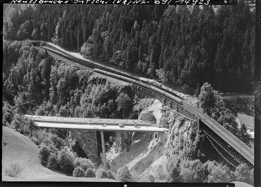
[edit]| National road N2/Motorway A2, Reuss bridge, with TEE train (Trans Europ Express)
( |
|||||||||||||||||||||||||||
|---|---|---|---|---|---|---|---|---|---|---|---|---|---|---|---|---|---|---|---|---|---|---|---|---|---|---|---|
| Author |
Comet Photo AG (Zürich) |
||||||||||||||||||||||||||
| Title |
National road N2/Motorway A2, Reuss bridge, with TEE train (Trans Europ Express) |
||||||||||||||||||||||||||
| Original caption |
N2, Reussbrücke, mit TEE-Zug (Trans Europ Express) |
||||||||||||||||||||||||||
| Description |
SBB Gotthard line between Amsteg-Silenen station and Intsch stop, front bottom right: 77 m high bridge over the Intschireuss, top left: Cantonal road overpass at Intschi |
||||||||||||||||||||||||||
| Depicted place | Intschi | ||||||||||||||||||||||||||
| Date | 23 May 1969 | ||||||||||||||||||||||||||
| Medium | Fotografie : Negativ | ||||||||||||||||||||||||||
| Dimensions | 13 x 18 cm | ||||||||||||||||||||||||||
| Collection |
|
||||||||||||||||||||||||||
| Accession number |
ETH-Bibliothek_LBS_H1-018752 Com_F69-14923 |
||||||||||||||||||||||||||
| Source |
ETH-Bibliothek Zürich, Bildarchiv / Fotograf: Comet Photo AG (Zürich) / Com_F69-14923 / CC BY-SA 4.0 / E-Pics Bildarchiv online http://doi.org/10.3932/ethz-a-000733727
|
||||||||||||||||||||||||||
| Permission (Reusing this file) |
This file is licensed under the Creative Commons Attribution-Share Alike 4.0 International license.
|
||||||||||||||||||||||||||

| Camera location | | View this and other nearby images on: OpenStreetMap |
|---|
Licensing
[edit]
This file is licensed under the Creative Commons Attribution-Share Alike 4.0 International license.
- You are free:
- to share – to copy, distribute and transmit the work
- to remix – to adapt the work
- Under the following conditions:
- attribution – You must give appropriate credit, provide a link to the license, and indicate if changes were made. You may do so in any reasonable manner, but not in any way that suggests the licensor endorses you or your use.
- share alike – If you remix, transform, or build upon the material, you must distribute your contributions under the same or compatible license as the original.
File history
Click on a date/time to view the file as it appeared at that time.
| Date/Time | Thumbnail | Dimensions | User | Comment | |
|---|---|---|---|---|---|
| current | 20:02, 6 January 2024 | | 3,072 × 2,206 (1.51 MB) | NAC (talk | contribs) | Uploaded a work by Comet Photo AG (Zürich) from ETH-Bibliothek Zürich, Bildarchiv / Fotograf: Comet Photo AG (Zürich) / Com_F69-14923 / CC BY-SA 4.0 / http://doi.org/10.3932/ethz-a-000733727 with UploadWizard |
You cannot overwrite this file.
File usage on Commons
The following page uses this file: