File:Early-medieval or medieval strap-end (FindID 555999).jpg
Jump to navigation
Jump to search

Size of this preview: 645 × 600 pixels. Other resolutions: 258 × 240 pixels | 516 × 480 pixels | 826 × 768 pixels | 1,101 × 1,024 pixels | 1,303 × 1,212 pixels.
Original file (1,303 × 1,212 pixels, file size: 794 KB, MIME type: image/jpeg)
Captions
Captions
Add a one-line explanation of what this file represents
Summary
[edit].jpg&action=edit§ion=1)
| Early-medieval or medieval strap-end | |||
|---|---|---|---|
| Photographer |
The Portable Antiquities Scheme, Helen Geake, 2016-02-02 13:57:41 |
||
| Title |
Early-medieval or medieval strap-end |
||
| Description |
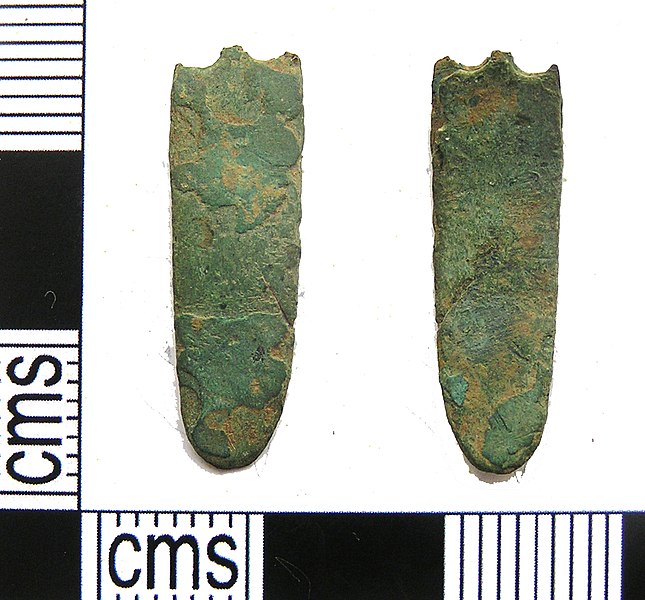
English: Strap-end made from two long sheets of copper alloy, presumably hammered and/or soldered together. The long edges are largely straight but taper at one end to a rounded terminal. The other end is broken across two circular rivet holes. There is no decoration surviving on either sheet, but both have lost much of their surface and the strap-end may originally have been decorated.
There is very little evidence to go on to suggest a date. Similar strap-ends are known from early Anglo-Saxon to medieval contexts, but the presence of two rivets rather than a single central one may argue for an earlier rather than later date. |
||
| Depicted place | (County of findspot) Hampshire | ||
| Date | between 450 and 1450 | ||
| Accession number |
FindID: 555999 Old ref: PUBLIC-F00772 Filename: PUBLICF00772.jpg |
||
| Credit line |
|
||
| Source |
https://finds.org.uk/database/ajax/download/id/551406 Catalog: https://finds.org.uk/database/images/image/id/551406/recordtype/artefacts archive copy at the Wayback Machine Artefact: https://finds.org.uk/database/artefacts/record/id/555999 |
||
| Permission (Reusing this file) |
Attribution License version 2.0 (verified 3 December 2020) | ||
| Object location | | View this and other nearby images on: OpenStreetMap |
|---|
.jpg¶ms=051.157200_N_-001.257540_E_globe:Earth_class:object_type:object__&language=en)
Licensing
[edit].jpg&action=edit§ion=2)
This file is licensed under the Creative Commons Attribution 2.0 Generic license.
Attribution: The Portable Antiquities Scheme
- You are free:
- to share – to copy, distribute and transmit the work
- to remix – to adapt the work
- Under the following conditions:
- attribution – You must give appropriate credit, provide a link to the license, and indicate if changes were made. You may do so in any reasonable manner, but not in any way that suggests the licensor endorses you or your use.
File history
Click on a date/time to view the file as it appeared at that time.
| Date/Time | Thumbnail | Dimensions | User | Comment | |
|---|---|---|---|---|---|
| current | 23:23, 12 February 2019 | | 1,303 × 1,212 (794 KB) | Fæ (talk | contribs) | Portable Antiquities Scheme, NFAHG, FindID: 555999, early medieval, page 4741, batch count 10462 |
You cannot overwrite this file.
File usage on Commons
The following page uses this file:
.jpg)
.jpg&oldid=546632152)