File:Early El Niño Signs (PIA25776).jpg

Original file (875 × 403 pixels, file size: 46 KB, MIME type: image/jpeg)
Captions
Captions
Summary
[edit]| Description |
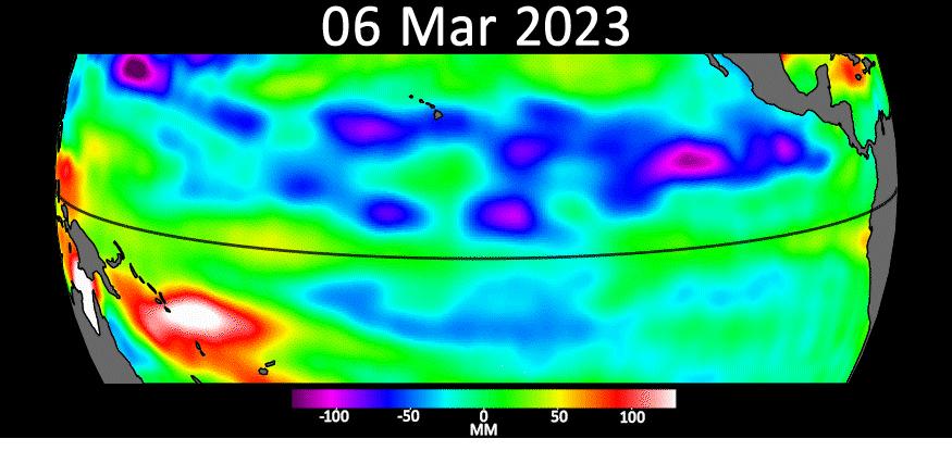
English: .png) Figure A Sea level data from the U.S.-European satellite Sentinel-6 Michael Freilich shows early signs of a developing El Niño along the equatorial Pacific Ocean. The measurements show Kelvin waves, low waves that can be tens of miles (hundreds of kilometers) wide, moving from west to east at the equator towards the west coast of Ecuador. When they form at the equator, Kelvin waves can move warm water – associated with higher sea levels – from the western Pacific to the eastern Pacific. El Niño is a periodic climate phenomenon that can affect weather patterns around the world. The condition can bring cooler, wetter conditions to the U.S. Southwest and drought to countries in the western Pacific such as Indonesia and Australia. El Niño is characterized by higher sea levels and warmer-than-average ocean temperatures along the western coasts of North and South America. Water expands as it warms, so sea levels tend to be higher in places with warmer water. The climate phenomenon is also associated with a weakening of the trade winds. The Sentinel-6 Michael Freilich satellite data shown here covers a seven-week period between the beginning of March and the end of April 2023. By April 24, Figure A, Kelvin waves had piled up warmer water and higher sea levels (shown in red and white) off the coasts of Peru, Ecuador, and Columbia. A series of Kelvin waves starting in spring is a well-known precursor to an El Niño. The waves seen during March and April 2023 are similar to the ones that preceded the 1997-1998 El Niño, one of the most powerful in recorded history. Satellites like Sentinel-6 Michael Freilich can detect Kelvin waves with an instrument called an altimeter that uses radar signals to measure the height of the ocean's surface. Warmer areas show up as higher sea levels. The satellite, named after former NASA Earth Science Division Director Michael Freilich, is one of two that compose the Copernicus Sentinel-6/Jason-CS (Continuity of Service) mission. Sentinel-6/Jason-CS was jointly developed by ESA (European Space Agency), the European Organisation for the Exploitation of Meteorological Satellites (EUMETSAT), NASA, and the National Oceanic and Atmospheric Administration, with funding support from the European Commission and technical support on performance from the French space agency CNES (Centre National d'Études Spatiales). Spacecraft monitoring and control, as well as the processing of all the altimeter science data, is carried out by EUMETSAT on behalf of the European Union's Copernicus programme, with the support of all partner agencies. NASA's Jet Propulsion Laboratory, a division of Caltech in Pasadena, contributed three science instruments for each Sentinel-6 satellite: the Advanced Microwave Radiometer, the Global Navigation Satellite System - Radio Occultation, and the Laser Retroreflector Array. NASA also contributed launch services, ground systems supporting operation of the NASA science instruments, the science data processors for two of these instruments, and support for the U.S. members of the international Ocean Surface Topography Science Team. |
| Date | (published) |
| Source | Catalog page · Full-res (JPEG · TIFF) · Full-res ([ MP4]) · Full-res ([ GIF]) |
| Author | NASA/JPL-Caltech |
| Other versions |
|

.jpg&action=edit§ion=1)
This image or video was catalogued by Jet Propulsion Laboratory of the United States National Aeronautics and Space Administration (NASA) under Photo ID: PIA25776. This tag does not indicate the copyright status of the attached work. A normal copyright tag is still required. See Commons:Licensing. Other languages:
|
| This media is a product of the Sentinel-6/Jason-CS Credit and attribution belongs to the mission team, if not already specified in the "author" row |
Licensing
[edit].jpg&action=edit§ion=2)

|
The copyright holder of this file, NASA/JPL-Caltech, allows anyone to use it for any purpose, provided that the copyright holder is properly attributed. Redistribution, derivative work, commercial use, and all other use is permitted. |
|
|
| According to JPL's image use policy additional restriction is that no endorsement of any product or service by Caltech, JPL or NASA is claimed or implied.
Caltech's disclaimer: Caltech makes no representations or warranties with respect to ownership of copyrights in the images, and does not represent others who may claim to be authors or owners of copyright of any of the images, and makes no warranties as to the quality of the images. Caltech shall not be responsible for any loss or expenses resulting from the use of the images, and you release and hold Caltech harmless from all liability arising from such use. Usage on the English Wikipedia: On the English Wikipedia you can use the {{JPL Image}} template to display the copyright notice. (See w:Wikipedia:Using JPL images for details) |
File history
Click on a date/time to view the file as it appeared at that time.
| Date/Time | Thumbnail | Dimensions | User | Comment | |
|---|---|---|---|---|---|
| current | 12:30, 5 May 2024 | | 875 × 403 (46 KB) | Don-vip (talk | contribs) | Cropped 3 % vertically using CropTool with precise mode. |
| 23:01, 24 August 2023 |  | 875 × 415 (50 KB) | OptimusPrimeBot (talk | contribs) | #Spacemedia - Upload of https://photojournal.jpl.nasa.gov/jpeg/PIA25776.jpg via Commons:Spacemedia |
You cannot overwrite this file.
File usage on Commons
The following 3 pages use this file:
.jpg&oldid=874107711)