File:Early medieval to early post-medieval spindle whorl (FindID 829793).jpg
Jump to navigation
Jump to search

Size of this preview: 800 × 381 pixels. Other resolutions: 320 × 152 pixels | 640 × 305 pixels | 1,024 × 487 pixels | 1,280 × 609 pixels | 2,560 × 1,218 pixels | 4,401 × 2,094 pixels.
Original file (4,401 × 2,094 pixels, file size: 3.4 MB, MIME type: image/jpeg)
Captions
Captions
Add a one-line explanation of what this file represents
Summary[edit]
.jpg&action=edit§ion=1)
| Early medieval to early post-medieval spindle whorl | |||
|---|---|---|---|
| Photographer |
Derby Museums Trust, Alastair Willis, 2017-07-18 15:41:39 |
||
| Title |
Early medieval to early post-medieval spindle whorl |
||
| Description |
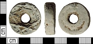
English: A complete lead or lead alloy early medieval, medieval or early post-medieval decorated thick disc spindle whorl. The object is circular in plan, rectangular in cross-section and has a large central sub-circular hole. One surface is decorated with a star-like motif formed of raised lines creating triangular depressions, some of which contain a raised pellet. Decorated spindle whorls are normally associated with the medieval period, but they are normally biconical. Rectangular cross-sectioned whorls are common from AD c. 900 but can date as early as AD c. 700.
The dimensions are: external diameter 26.6mm, internal diameter 7.5mm, thickness 8.6 mm and weight 36.39g. |
||
| Depicted place | (County of findspot) Derbyshire | ||
| Date | between 700 and 1600 | ||
| Accession number |
FindID: 829793 Old ref: DENO-B3714E Filename: DENOB3714E.jpg |
||
| Credit line |
|
||
| Source |
https://finds.org.uk/database/ajax/download/id/622474 Catalog: https://finds.org.uk/database/images/image/id/622474/recordtype/artefacts archive copy at the Wayback Machine Artefact: https://finds.org.uk/database/artefacts/record/id/829793 |
||
| Permission (Reusing this file) |
Attribution License version 2.0 (verified 24 November 2020) | ||
| Object location | | View this and other nearby images on: OpenStreetMap |
|---|
.jpg¶ms=053.274600_N_-001.839610_E_globe:Earth_class:object_type:object__&language=en)
Licensing[edit]
.jpg&action=edit§ion=2)
This file is licensed under the Creative Commons Attribution 2.0 Generic license.
Attribution: Derby Museums Trust
- You are free:
- to share – to copy, distribute and transmit the work
- to remix – to adapt the work
- Under the following conditions:
- attribution – You must give appropriate credit, provide a link to the license, and indicate if changes were made. You may do so in any reasonable manner, but not in any way that suggests the licensor endorses you or your use.
File history
Click on a date/time to view the file as it appeared at that time.
| Date/Time | Thumbnail | Dimensions | User | Comment | |
|---|---|---|---|---|---|
| current | 20:37, 14 December 2018 | | 4,401 × 2,094 (3.4 MB) | Fæ (talk | contribs) | Portable Antiquities Scheme, DENO, FindID: 829793, medieval, page 1328, batch count 2131 |
You cannot overwrite this file.
File usage on Commons
The following page uses this file:
.jpg)
.jpg&oldid=546463117)