File:Earth from Space- Côte d'Ivoire ESA25482285.tiff

Original file (8,446 × 8,446 pixels, file size: 204.12 MB, MIME type: image/tiff)
Captions
Captions
Summary
[edit]| Warning | The original file is very high-resolution. It might not load properly or could cause your browser to freeze when opened at full size. |
|---|
| Description |
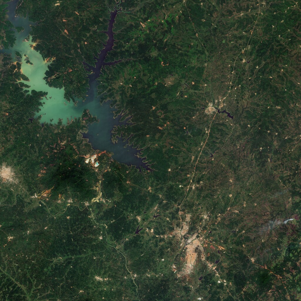
English: The Copernicus Sentinel-2 mission takes us over Côte d'Ivoire in western Africa. Zoom in to explore this image at its full 10 m resolution or click on the circles to learn more. Côte d'Ivoire is located on the southern coast of west Africa on the Gulf of Guinea. Acquired in December 2023 during the dry season, this image shows the central part of the country, which is mainly forested but dotted with numerous villages and towns, visible in light brown. The country’s capital Yamoussoukro can be seen at the bottom of the image. Zooming into the larger urban settlements in the image, buildings stand out in white. Northwest of Yamoussoukro lies Lake Kossou, the largest water body in the country, covering about 1700 sq km. It is an important habitat for aquatic animals and an increasing number of bird species that have been recorded living here or visiting the area. Lake Koussou is an artificial basin created from the construction of the Kossou Dam across the Bandama River. Strategic for the country’s economy in terms of both agricultural and energy production, the dam is the largest in the country. It is visible on the southern shore of the lake, where the Bandama River resumes its course southward. Bandama is the longest and, commercially, the most important river in Côte d’Ivoire. It drains half of the surface area of the country before entering the Gulf of Guinea. The reddish areas throughout the image denote high iron concentrations in the soil. Like many countries in west Africa, Cote d’Ivoire is experiencing the effects of the climate crisis, such as drought. Earth observing satellites, such as Copernicus Sentinel-2, can help monitor fluctuations in water levels over time and support the sustainable management of water resources. |
| Date | 16 February 2024 (upload date) |
| Source | Earth from Space: Côte d'Ivoire |
| Author | European Space Agency |
| Other versions |
|
| Activity | Observing the Earth |
| Mission | Sentinel-2 |
| Set | Earth from Space image collection |
| System | Copernicus |

Licensing
[edit]
|
This image contains data from a satellite in the Copernicus Programme, such as Sentinel-1, Sentinel-2 or Sentinel-3. Attribution is required when using this image.
Attribution: Contains modified Copernicus Sentinel data 2023
The use of Copernicus Sentinel Data is regulated under EU law (Commission Delegated Regulation (EU) No 1159/2013 and Regulation (EU) No 377/2014). Relevant excerpts:
Free access shall be given to GMES dedicated data [...] made available through GMES dissemination platforms [...].
Access to GMES dedicated data [...] shall be given for the purpose of the following use in so far as it is lawful:
GMES dedicated data [...] may be used worldwide without limitations in time.
GMES dedicated data and GMES service information are provided to users without any express or implied warranty, including as regards quality and suitability for any purpose. |
This media was created by the European Space Agency (ESA).
Where expressly so stated, images or videos are covered by the Creative Commons Attribution-ShareAlike 3.0 IGO (CC BY-SA 3.0 IGO) licence, ESA being an Intergovernmental Organisation (IGO), as defined by the CC BY-SA 3.0 IGO licence. The user is allowed under the terms and conditions of the CC BY-SA 3.0 IGO license to Reproduce, Distribute and Publicly Perform the ESA images and videos released under CC BY-SA 3.0 IGO licence and the Adaptations thereof, without further explicit permission being necessary, for as long as the user complies with the conditions and restrictions set forth in the CC BY-SA 3.0 IGO licence, these including that:
See the ESA Creative Commons copyright notice for complete information, and this article for additional details.
|
 | |
This file is licensed under the Creative Commons Attribution-ShareAlike 3.0 IGO license. Attribution: ESA, CC BY-SA IGO 3.0
| ||
File history
Click on a date/time to view the file as it appeared at that time.
| Date/Time | Thumbnail | Dimensions | User | Comment | |
|---|---|---|---|---|---|
| current | 18:13, 16 February 2024 |  | 8,446 × 8,446 (204.12 MB) | OptimusPrimeBot (talk | contribs) | #Spacemedia - Upload of https://esamultimedia.esa.int/img/2024/02/yamoussoukro_S2_20231213_10m_CF.tif via Commons:Spacemedia |
| 18:12, 16 February 2024 |  | 8,446 × 8,446 (204.12 MB) | OptimusPrimeBot (talk | contribs) | #Spacemedia - Upload of https://esamultimedia.esa.int/img/2024/02/yamoussoukro_S2_20231213_10m_CF.tif via Commons:Spacemedia |
You cannot overwrite this file.
File usage on Commons
The following page uses this file: