File:Earthquake wave paths.de.svg
Jump to navigation
Jump to search

Size of this PNG preview of this SVG file: 300 × 250 pixels. Other resolutions: 288 × 240 pixels | 576 × 480 pixels | 922 × 768 pixels | 1,229 × 1,024 pixels | 2,458 × 2,048 pixels.
Original file (SVG file, nominally 300 × 250 pixels, file size: 25 KB)
Captions
Captions
Add a one-line explanation of what this file represents
Summary
[edit]
| Description |
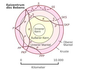
English: Cross section of the whole Earth, showing the complexity of paths of earthquake waves. The paths curve because the different rock types found at different depths change the speed at which the waves travel. Solid lines marked P are compressional waves; dashed lines marked S are shear waves. S waves do not travel through the core but may be converted to compressional waves (marked K) on entering the core (PKP, SKS). Waves may be reflected at the surface (PP, PPP, SS). Seismographs detect the various types of waves. Analysis of such records reveals structures within the Earth.
Deutsch: Querschnitt der Erde mit seismischen Wellen verschiedener Phasen |
| Date | (UTC) |
| Source |
This file was derived from: Earthquake wave paths.svg: |
| Author |
USGS |
| This is a retouched picture, which means that it has been digitally altered from its original version. Modifications: Deutsch. The original can be viewed here: Earthquake wave paths.svg:
|
Licensing
[edit]
This image is in the public domain in the United States because it only contains materials that originally came from the United States Geological Survey, an agency of the United States Department of the Interior. For more information, see the official USGS copyright policy.
|
Original upload log
[edit]
This image is a derivative work of the following images:
- File:Earthquake wave paths.svg licensed with PD-USGov-Interior-USGS
File history
Click on a date/time to view the file as it appeared at that time.
| Date/Time | Thumbnail | Dimensions | User | Comment | |
|---|---|---|---|---|---|
| current | 15:39, 10 May 2015 | | 300 × 250 (25 KB) | Sonne7 (talk | contribs) | Korrektur der Unschönheiten in den automatisch generierten PNG-Bildern (konkret 1. neuen Positionslinie wieder entfernt (reichte im PNG ins Textfeld) und 2. Detailpositionierung aller Beschriftungen etwas optimiert) - Anm.: allerdings blind erfolgt (w... |
| 04:40, 10 May 2015 |  | 300 × 250 (25 KB) | Sonne7 (talk | contribs) | Korrektur der Namen der 2 Mantelschichten ('Unterer *' und 'Oberer *', laut englischem Original, sowie laut den Artikeln Erde und Innerer Aufbau der Erde). Colorierung hinzugefügt (waren bisher nur braune Linien) - konkret 1. die verschiedenen... | |
| 19:45, 28 March 2013 |  | 300 × 250 (24 KB) | Kopiersperre (talk | contribs) | fix | |
| 19:13, 28 March 2013 |  | 300 × 250 (24 KB) | Kopiersperre (talk | contribs) | == {{int:filedesc}} == {{Information |Description={{en|Cross section of the whole Earth, showing the complexity of paths of earthquake waves. The paths curve because the different rock types found at differe... |
You cannot overwrite this file.
File usage on Commons
The following page uses this file:
File usage on other wikis
The following other wikis use this file:
- Usage on de.wikipedia.org
- Usage on nds.wikipedia.org