File:East-Hem 1100ad.jpg

Fitxer original (3.240 × 1.903 píxels, mida del fitxer: 3,16 Mo, tipus MIME: image/jpeg)
Llegendes
Llegendes

|
Aquesta imatge (de tipus historical map) s'hauria de tornar a crear utilitzant gràfics vectorials com ara un fitxer SVG. Això té diversos avantatges; en trobareu més informació a Commons:Media for cleanup. Si ja disposeu d'una versió d'aquesta imatge en format SVG, us preguem que la pengeu; després, reemplaceu aquesta plantilla amb la plantilla {{Vector version available|nom nou de la imatge.svg}} en aquesta imatge.
|


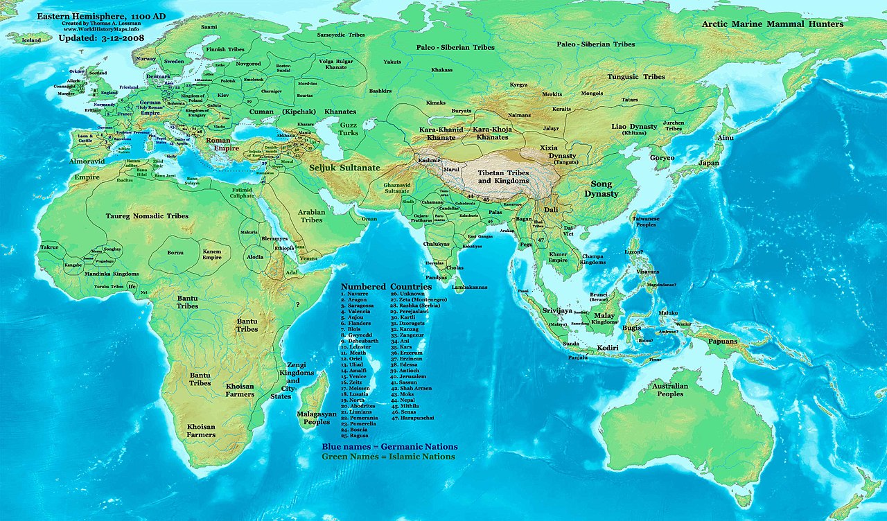
| Descripció | Eastern Hemisphere in 1100 AD. |
| Font | self-made (For reference information, see the Map Source References section below.) |
| Autor | Thomas Lessman (Contact!) |
| Permís (Com reutilitzar aquest fitxer) |
Jo, el titular dels drets d'autor d'aquest treball, el public sota la següent llicència: Aquest fitxer està subjecte a la llicència de Creative Commons Reconeixement i Compartir Igual 3.0 No adaptada.
|
| Altres versions | see East-Hem_1100ad.jpg file history on Wikipedia. |
Map Summary
[modifica]
Original Source URL: http://www.thomaslessman.com/History/images/East-Hem_1100ad.jpg.
This map of the Eastern Hemisphere in 1100 AD was created by Thomas Lessman, based on information from the sources listed below. This map is free for educational use (see Permission info above). When using this map, please mention that it is available for free at www.WorldHistoryMaps.info.
Keep in mind that sources often conflict with each other, and they are as accurate as the information that is available to me. To report any errors, or if you want to help further this work, please see here, or email Thomas Lessman at talessman@yis.us.
Map Source References
[modifica]
- Remember, sources often conflict with each other. This map is only as accurate as the information that is available to me. To report any errors or to help further this work, please click here, or email Thomas Lessman at talessman@yis.us
References for information contained in this map:
1. Borders of Europe are mostly derived from the www.Euratlas.com map of Europe in 1100 AD.
- (Please note: Bogomolov.PL has done a great job of showing me possible discrepancies in my north European borders compared to this source, due to the differences in the geographical layout of the maps.)
2. Borders of Asian countries derive from various Wikipedia articles and Google history map searches.
3. Much of the information in this map was cross-checked with Bruce Gordon's Regnal Chronologies.
Other Maps by Thomas Lessman
[modifica]
| Maps of the eastern hemisphere showing history
Bold dates are available on Wikimedia or Wikipedia. | ||
| Primeval | ||
| Ancient
|
·| 600 BC | 550 BC | 527 BC | 500 BC |
400 BC | ·| 1 AD | 50 AD | 100 AD | 200 AD | 300 AD | | |
| Medieval |
·| 500 AD | 565 AD | 600 AD | 700 AD | | |
| Modern |
·| 1500 AD | · * For historical maps of the whole world, | |
Other Info
[modifica]
Historial del fitxer
Cliqueu una data/hora per veure el fitxer tal com era aleshores.
| Data/hora | Miniatura | Dimensions | Usuari/a | Comentari | |
|---|---|---|---|---|---|
| actual | 11:16, 16 gen 2009 | | 3.240 × 1.903 (3,16 Mo) | Ukabia (discussió | contribucions) | {{Information |Description= |Source= |Date= |Author= |Permission= |other_versions= }} |
| 20:46, 9 maig 2008 |  | 3.240 × 1.903 (782 Ko) | Talessman (discussió | contribucions) | {{Information |Description=Eastern Hemisphere in 1100 AD. |Source=self-made |Author=Thomas Lessman |Permission={{self|cc-by-sa-3.0}} }} |
No podeu sobreescriure aquest fitxer.
Ús del fitxer
Les 2 pàgines següents utilitzen aquest fitxer:
Ús global del fitxer
Utilització d'aquest fitxer en altres wikis:
- Utilització a arz.wikipedia.org
- Utilització a azb.wikipedia.org
- Utilització a be.wikipedia.org
- Utilització a bs.wikipedia.org
- Utilització a de.wikipedia.org
- Utilització a de.wikiversity.org
- Utilització a en.wikipedia.org
- Utilització a es.wikipedia.org
- Utilització a et.wikipedia.org
- Utilització a fr.wikipedia.org
- Utilització a gl.wikipedia.org
- Utilització a hu.wikipedia.org
- Utilització a mk.wikipedia.org
- Utilització a mr.wikipedia.org
- Utilització a my.wikipedia.org
- Utilització a nn.wikipedia.org
- Utilització a ro.wikipedia.org
- Utilització a rue.wikipedia.org
- Utilització a shn.wikipedia.org
- Utilització a sh.wikipedia.org
- Utilització a si.wikipedia.org
- Utilització a sv.wikipedia.org
- Utilització a sw.wikipedia.org
- Utilització a ta.wikipedia.org
- Utilització a tl.wikipedia.org
- Utilització a uk.wikipedia.org
- Utilització a ur.wikipedia.org
- Utilització a vi.wikipedia.org