File:East-Hem 200ad.jpg

元のファイル (3,240 × 1,903 ピクセル、ファイルサイズ: 734キロバイト、MIME タイプ: image/jpeg)
キャプション
キャプション

|
このhistorical map画像は、ベクターイメージである SVG ファイルとして再作成されるべきです。これにはいくつかの利点があります。詳しくはCommons:Media for cleanupを参照してください。この画像の SVG 形式がすでに利用可能である場合は、アップロードしてください。アップロード後、この画像にあるこのテンプレートを{{Vector version available|新しい画像ファイル名.svg}}テンプレートで置き換えてください。
|


概要
[編集]
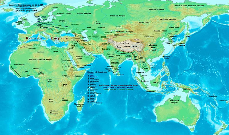
| 解説 | Eastern Hemisphere in 200 AD. |
| 原典 | self-made (For reference information, see the Map Source References section below.) |
| 作者 | Thomas Lessman (Contact!) |
| 許可 (ファイルの再利用) |
この作品の著作権者である私は、この作品を以下のライセンスで提供します。 このファイルはクリエイティブ・コモンズ 表示-継承 3.0 非移植ライセンスのもとに利用を許諾されています。
|
| その他のバージョン |
このファイルの派生的著作物: Part of East Hem 200 AD.jpg see East-Hem_200ad.jpg file history on Wikipedia. |
Map Summary
[編集]
Original Source URL: http://www.thomaslessman.com/History/images/East-Hem_200ad.jpg.
This map of the Eastern Hemisphere in 200 AD was created by Thomas Lessman, based on information from the sources listed below. This map is free for educational use (see Permission info above). When using this map, please mention that it is available for free at www.WorldHistoryMaps.info.
Map Source References
[編集]
- Remember, sources often conflict with each other. This map is only as accurate as the information that is available to me. To report any errors or to help further this work, please click here, or email Thomas Lessman at talessman@yis.us
References for information contained in this map:
Primary Sources:
- 1. The DK Atlas of World History, 2000 Edition; map of The World in 250 CE, (Pages 46-47).
- 2. History and Commercial Atlas of China; map of Asia in 200 AD; available on Huhai.net.
- 3. Countries of the World, 1-1-136 CE アーカイブされたコピー at the Wayback Machine map available on www.WorldHistoryMaps.com.
- 4. Map of the World in 200 CE, created by Wikimedia's User:Javierfv1212.
I - European Information is derived primarily from this Map of Europe in 200 AD from www.Euratlas.com.
II - Asian Information is derived primarily from:
- Han Dynasty borders are derived from the History and Commercial Atlas of China (see above, #2 under Primary Sources).
- Indian borders are derived from a combination of these sources:
- Wikimedia's map of the World in 200 CE, created by User:Javierfv1212.
- This map of the Countries of the World, 1-1-136 CE アーカイブされたコピー at the Wayback Machine, available on www.WorldHistoryMaps.com.
- Wikimedia's map of Western Kshatrapas (Western Satraps), created by User:PHG.
- Wikimedia's Satavahana Map, created by User:PHG.
- Korean borders derive from this map of Korea-204.png made by Wikipedia User:Historiographer.
- Kushan Empire borders are derived from a mix of the sources below:
- The DK Atlas of World History (see above, #1 under Primary Sources).
- History and Commercial Atlas of China (see above, #2 under Primary Sources).
- Parthian Empire borders derive from:
- History and Commercial Atlas of China (see above, #2 under Primary Sources).
- Wikimedia's map of the World in 200 CE (see above, #4 under Primary Sources).
- Roman borders in Asia, along with borders for states in Iraq and Caucasus Mts, are derived from the Map of Europe in 200 AD from www.Euratlas.com.
III - African Information, and fringe areas like Australia, Siberia, etc. derive from:
- Wikimedia's map of the World in 200 CE, created by User:Javierfv1212.
- The DK Atlas of World History, 2000 Edition; map of The development of complex societies in Africa; (Page 160).
Note: Much of the information in this map was cross-checked with Bruce Gordon's Regnal Chronologies.
Other Maps by Thomas Lessman
[編集]
| Maps of the eastern hemisphere showing history
Bold dates are available on Wikimedia or Wikipedia. | ||
| Primeval | ||
| Ancient
|
·| 600 BC | 550 BC | 527 BC | 500 BC |
400 BC | ·| 1 AD | 50 AD | 100 AD | 200 AD | 300 AD | | |
| Medieval |
·| 500 AD | 565 AD | 600 AD | 700 AD | | |
| Modern |
·| 1500 AD | · * For historical maps of the whole world, | |
Other Info
[編集]
ファイルの履歴
過去の版のファイルを表示するには、その版の日時をクリックしてください。
| 日付と時刻 | サムネイル | 寸法 | 利用者 | コメント | |
|---|---|---|---|---|---|
| 現在の版 | 2008年5月26日 (月) 00:22 | | 3,240 × 1,903 (734キロバイト) | Talessman (トーク | 投稿記録) | Corrections to borders in West Asia, India, Southeast Asia, China, and Korea. Added more information based on new references. Other misc. corrections and updates. |
| 2008年5月9日 (金) 16:27 |  | 3,240 × 1,903 (720キロバイト) | Talessman (トーク | 投稿記録) | {{Information |Description=Eastern Hemisphere in 200 AD. |Source=self-made |Author=Thomas Lessman |Permission={{self|cc-by-sa-3.0}} }} |
このファイルは上書きできません。
ファイルの使用状況
以下の 5 ページがこのファイルを使用しています:
グローバルなファイル使用状況
以下に挙げる他のウィキがこの画像を使っています:
- ar.wikipedia.org での使用状況
- be-tarask.wikipedia.org での使用状況
- bg.wikipedia.org での使用状況
- bn.wikipedia.org での使用状況
- bs.wikipedia.org での使用状況
- ca.wikipedia.org での使用状況
- cv.wikipedia.org での使用状況
- de.wikipedia.org での使用状況
- el.wikipedia.org での使用状況
- en.wikipedia.org での使用状況
- 3rd century
- 200
- Proto-Mongols
- History of Eurasia
- Chutu dynasty
- Talk:Odia language
- User:Tompw/sandbox10
- User:Talessman/Maps
- User talk:Talessman/Maps
- Timeline of ancient history
- Comparative studies of the Roman and Han empires
- User:Benjamin Trovato/sandbox
- Nagas of Padmavati
- List of Classical Age states
- User:Joelton Ivson/Gather lists/24978 – Os Romanos
- Achyuta of Panchala
- User:Falcaorib/Ancient East Hemisphere
- en.wikibooks.org での使用状況
- en.wikiversity.org での使用状況
- eo.wikipedia.org での使用状況
- es.wikipedia.org での使用状況
- fi.wikipedia.org での使用状況
- frr.wikipedia.org での使用状況
- gl.wikipedia.org での使用状況
- he.wikipedia.org での使用状況
- hy.wikipedia.org での使用状況
- id.wikipedia.org での使用状況
- it.wikipedia.org での使用状況
- jv.wikipedia.org での使用状況
- km.wikipedia.org での使用状況
- ko.wikipedia.org での使用状況
- lv.wikipedia.org での使用状況
このファイルのグローバル使用状況を表示する。