File:East Antarctica Ice Shelf Collapse (MODIS 2022-03-31).jpg

Original file (1,214 × 908 pixels, file size: 175 KB, MIME type: image/jpeg)
Captions
Captions
Summary[edit]
.jpg&action=edit§ion=1)
| Description |
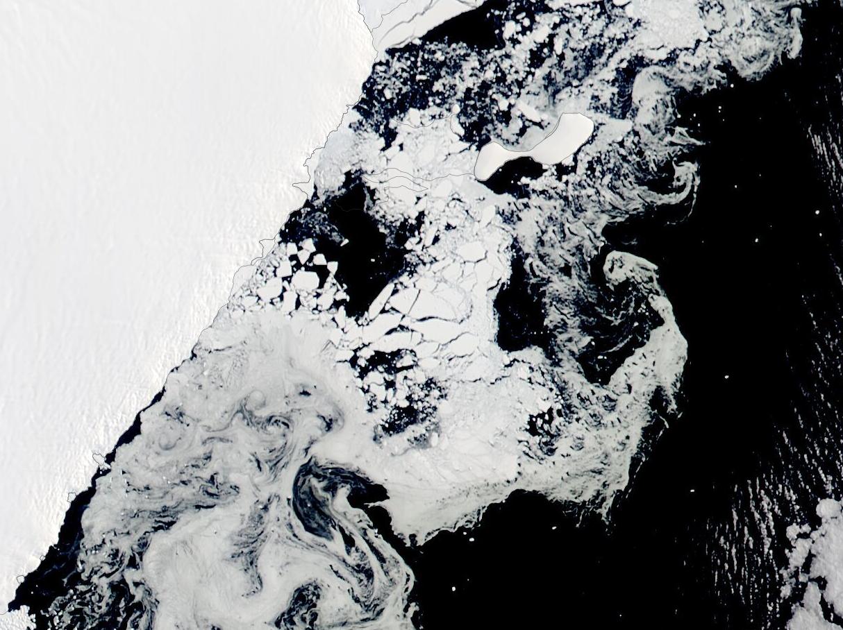
English: It is relatively common for ice shelves in Antarctica to spawn icebergs. It is less common for an ice shelf to completely disintegrate. In March 2022, an ice shelf in East Antarctica did both. The collapse has reshaped a part of the Antarctic landscape where coastal glacial ice was once thought to be stable. The disintegration of the entire shelf took just about two weeks. The icy remnants of both glacial shelf ice and adjacent sea ice dispersed from the waters around Bowman Island within weeks.
The change happened fast. At the start of March 2022, the floating shelf fed by the Glenzer and Conger glaciers was still intact. By the middle of the month, it had fallen apart. This true-color image, acquired by the Moderate Resolution Imaging Spectroradiometer (MODIS) on board NASA’s Aqua satellite on March 21, shows the shelf after it had disintegrated. Thanks to the NASA Worldview App, a roll-over comparison of this image and an Aqua MODIS image acquired of the same area on January 15, 2022—when the ice shelf appeared intact—can be viewed here On January 15, the ice shelf floats on the Mawson Sea and appears solidly attached to the coastline, surrounded by open water as well as sea ice and ice bergs. Some areas of the ice shelf appear to be pitted and bits of open water can be seen on the lower right section of the shelf. The shelf had been noted to be in decline for the last two years, with scientists estimating that the shelf was losing ice at an average rate of about 1 square kilometer (1.08 sq. foot) per day through the natural process of iceberg calving. In early March 2022, the shelf in front of the Glenzer Glacier calved a substantial iceberg. Named C-37, the berg initially measured about 144 square kilometers (56 square miles). The substantial loss of ice meant the shelf disconnected from Bowman Island, although some sea ice remained attached to the island. Loss of the land anchor on Bowman Island destabilized the ice shelf, priming it for collapse. Shortly after, on March 15, a weather system brought high temperatures (40˚C above normal), enhanced ocean swells, and heavy winds near the ice shelf. By March 16 the shelf was undergoing its final collapse, and in doing so it spawned Iceberg C-38, which at the time measured about 415 square kilometers (160 square miles). The loss of an ice shelf may indirectly contribute to sea level rise, as the ice shelves serve as ‘safety bands’ protecting the rest of the Antarctic ice sheet. When an ice shelf collapses, it may allow ice behind them to flow into the ocean more quickly, increasing the risk of sea level rise. This particular ice shelf and the surrounding glaciers are relatively small, so the impact from this solitary event is likely to be minimal. However, this is the first collapse in East Antarctica, where scientists have, until recently, considered the ice relatively stable. The demise of this ice shelf may signal a potential for more rapid melting of Antarctic ice than expected, leading to faster sea level rise. |
||
| Date | Taken on 21 March 2022 | ||
| Source |
East Antarctica Ice Shelf Collapse (direct link)
|
||
| Author | MODIS Land Rapid Response Team, NASA GSFC |
| This media is a product of the Aqua mission Credit and attribution belongs to the mission team, if not already specified in the "author" row |
Licensing[edit]
.jpg&action=edit§ion=2)
| This file is in the public domain in the United States because it was solely created by NASA. NASA copyright policy states that "NASA material is not protected by copyright unless noted". (See Template:PD-USGov, NASA copyright policy page or JPL Image Use Policy.) | ||
 |
Warnings:
|
File history
Click on a date/time to view the file as it appeared at that time.
| Date/Time | Thumbnail | Dimensions | User | Comment | |
|---|---|---|---|---|---|
| current | 22:10, 9 January 2024 | | 1,214 × 908 (175 KB) | OptimusPrimeBot (talk | contribs) | #Spacemedia - Upload of http://modis.gsfc.nasa.gov/gallery/images/image03312022_250m.jpg via Commons:Spacemedia |
You cannot overwrite this file.
File usage on Commons
There are no pages that use this file.
.jpg&oldid=840068869)