File:East Prussia 1923-1939 map-el.svg
Jump to navigation
Jump to search

Size of this PNG preview of this SVG file: 651 × 600 pixels. Other resolutions: 261 × 240 pixels | 521 × 480 pixels | 834 × 768 pixels | 1,111 × 1,024 pixels | 2,223 × 2,048 pixels | 865 × 797 pixels.
Original file (SVG file, nominally 865 × 797 pixels, file size: 170 KB)
Captions
Captions
Add a one-line explanation of what this file represents
Summary[edit]
| Description |
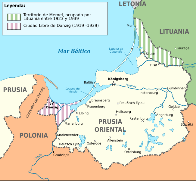
Ελληνικά: Χάρτης της γερμανικής επαρχίας της Ανατολικής Πρωσίας στα ελληνικά. |
| Date | |
| Source | Το αρχείο προέρχεται από το File:East_Prussia_1923-1939_map-es.svg και πρόκειται για την ελληνική μετάφραση του. |
| Author | NikosLikomitros για την ελληνική μετάφραση, Romanwindwhistler για το ισπανικό πρωτότυπο. |
| Other versions |
[]
|


Licensing[edit]
This file is licensed under the Creative Commons Attribution-Share Alike 4.0 International license.
- You are free:
- to share – to copy, distribute and transmit the work
- to remix – to adapt the work
- Under the following conditions:
- attribution – You must give appropriate credit, provide a link to the license, and indicate if changes were made. You may do so in any reasonable manner, but not in any way that suggests the licensor endorses you or your use.
- share alike – If you remix, transform, or build upon the material, you must distribute your contributions under the same or compatible license as the original.
File history
Click on a date/time to view the file as it appeared at that time.
| Date/Time | Thumbnail | Dimensions | User | Comment | |
|---|---|---|---|---|---|
| current | 15:02, 17 September 2022 | | 865 × 797 (170 KB) | NikosLikomitros (talk | contribs) | Uploaded a work by NikosLikomitros για την ελληνική μετάφραση, Romanwindwhistler για το ισπανικό πρωτότυπο. from Το αρχείο προέρχεται από το File:East_Prussia_1923-1939_map-es.svg και πρόκειται για την ελληνική μετάφραση του. with UploadWizard |
You cannot overwrite this file.
File usage on Commons
The following 12 pages use this file:
- User:Magog the Ogre/Multilingual legend/2022 September 11-20
- File:East Prussia 1923-1939.png
- File:East Prussia 1923-1939.svg
- File:East Prussia 1923-1939 map-el.svg
- File:East Prussia 1923-1939 map-es.svg
- File:East Prussia 1923-1939 map-fr.svg
- File:East Prussia 1923-1939 map-nl.svg
- File:East Prussia 1923-1939 map-zh-hans.svg
- File:East Prussia 1923-1939 map hu.svg
- File:East Prussia 1939.JPG
- File:Ostpreußen hu 1923-1939.jpg
- Template:Other versions/East Prussia 1923-1939