File:East of England counties 2019 map.svg
Jump to navigation
Jump to search

Size of this PNG preview of this SVG file: 573 × 600 pixels. Other resolutions: 229 × 240 pixels | 459 × 480 pixels | 734 × 768 pixels | 979 × 1,024 pixels | 1,957 × 2,048 pixels | 1,210 × 1,266 pixels.
Original file (SVG file, nominally 1,210 × 1,266 pixels, file size: 2.26 MB)
Captions
Captions
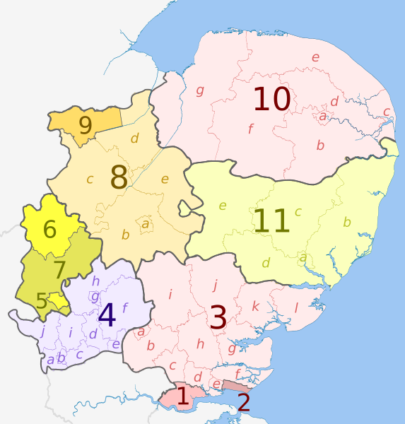
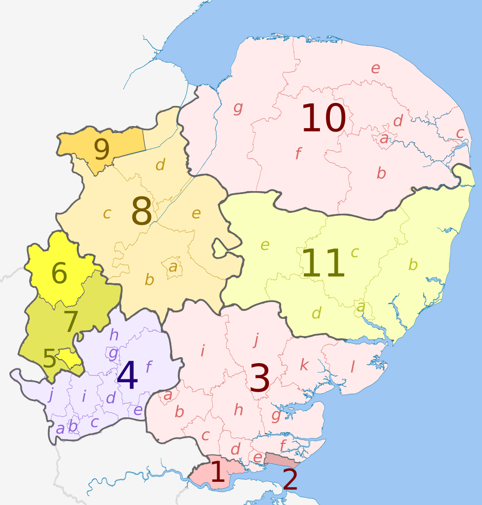
Map of counties and districts in the East of England region in 2019
Summary[edit]
| Description |
English: Map of the East of England region, showing its counties and administrative districts since 1 April 2019. The county colours are the same as those in File:English metropolitan and non-metropolitan counties 2009.svg.
Equirectangular map projection on WGS 84 datum, with N/S stretched 160% Geographic limits:
|
| Date | |
| Source |
This file was derived from: East of England counties 2009 map.svg:  |
| Author |
Key[edit]
Licensing[edit]
This file is licensed under the Creative Commons Attribution-Share Alike 3.0 Unported license.
Attribution: Dr Greg and Nilfanion. Contains Ordnance Survey data © Crown copyright and database right 2010
- You are free:
- to share – to copy, distribute and transmit the work
- to remix – to adapt the work
- Under the following conditions:
- attribution – You must give appropriate credit, provide a link to the license, and indicate if changes were made. You may do so in any reasonable manner, but not in any way that suggests the licensor endorses you or your use.
- share alike – If you remix, transform, or build upon the material, you must distribute your contributions under the same or compatible license as the original.
File history
Click on a date/time to view the file as it appeared at that time.
| Date/Time | Thumbnail | Dimensions | User | Comment | |
|---|---|---|---|---|---|
| current | 20:32, 28 May 2023 | | 1,210 × 1,266 (2.26 MB) | Dr Greg (talk | contribs) | Uploaded a work by * ''East of England counties 2009 map.svg'': Dr Greg and Nilfanion, contains Ordnance Survey data * derivative work: Dr Greg from {{Derived from|East of England counties 2009 map.svg|display=50}} with UploadWizard |
You cannot overwrite this file.
File usage on Commons
There are no pages that use this file.
File usage on other wikis
The following other wikis use this file:
- Usage on en.wikipedia.org