File:East of Jicarita Peak - Flickr - aspidoscelis.jpg
Jump to navigation
Jump to search

Size of this preview: 800 × 533 pixels. Other resolutions: 320 × 213 pixels | 640 × 427 pixels | 1,024 × 683 pixels | 1,280 × 853 pixels | 2,560 × 1,707 pixels | 3,600 × 2,400 pixels.
Original file (3,600 × 2,400 pixels, file size: 4.44 MB, MIME type: image/jpeg)
Captions
Captions
Add a one-line explanation of what this file represents
Summary
[edit]
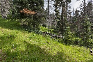
| Description | Sangre de Cristo Mountains, south-southeast of Taos, about 4 miles east of Jicarita Peak on the north side of F.R. 161, 36.05469 -105.49312, Taos County, New Mexico, 25 Jun 2017. Sambucus racemosa, Ligusticum porteri, Cymopterus lemmonii, Maianthemum stellatum, Achillea millefolium, Antennaria parvifolia, Cirsium parryi, Erigeron eximius, Hymenoxys hoopesii, Senecio eremophilus, Taraxacum officinale, Mertensia franciscana, Phacelia heterophylla, Lonicera involucrata, Symphoricarpos rotundifolius, Carex, Pteridium aquilinum, Trifolium repens, Vicia americana, Geranium richardsonii, Chamerion angustifolium, Picea engelmannii, Dactylis glomerata, Poa pratensis, Thalictrum fendleri, Fragaria virginiana, Rubus idaeus, Galium boreale, Populus tremuloides, Viola canadensis, etc. |
| Date | |
| Source | East of Jicarita Peak |
| Author | Patrick Alexander from Las Cruces, NM |
| Camera location | | View this and other nearby images on: OpenStreetMap |
|---|
Licensing
[edit]
| This file is made available under the Creative Commons CC0 1.0 Universal Public Domain Dedication. | |
| The person who associated a work with this deed has dedicated the work to the public domain by waiving all of their rights to the work worldwide under copyright law, including all related and neighboring rights, to the extent allowed by law. You can copy, modify, distribute and perform the work, even for commercial purposes, all without asking permission.
|
| This image was originally posted to Flickr by aspidoscelis at https://flickr.com/photos/26246711@N00/23874609838. It was reviewed on 3 October 2020 by FlickreviewR 2 and was confirmed to be licensed under the terms of the cc-zero. |
File history
Click on a date/time to view the file as it appeared at that time.
| Date/Time | Thumbnail | Dimensions | User | Comment | |
|---|---|---|---|---|---|
| current | 14:41, 3 October 2020 | | 3,600 × 2,400 (4.44 MB) | Josve05a (talk | contribs) | == {{int:filedesc}} == =={{int:filedesc}}== {{Information |Description=Sangre de Cristo Mountains, south-southeast of Taos, about 4 miles east of Jicarita Peak on the north side of F.R. 161, 36.05469 -105.49312, Taos County, New Mexico, 25 Jun 2017. ''Sambucus racemosa, Ligusticum porteri, Cymopterus lemmonii, Maianthemum stellatum, Achillea millefolium, Antennaria parvifolia, Cirsium parryi, Erigeron eximius, Hymenoxys hoopesii, Senecio eremophilus, Taraxacum officinale, Mertensia franciscan... |
You cannot overwrite this file.
File usage on Commons
There are no pages that use this file.