File:Easter Island map-it.svg
Jump to navigation
Jump to search

Size of this PNG preview of this SVG file: 800 × 569 pixels. Other resolutions: 320 × 228 pixels | 640 × 455 pixels | 1,024 × 729 pixels | 1,280 × 911 pixels | 2,560 × 1,821 pixels | 1,750 × 1,245 pixels.
Original file (SVG file, nominally 1,750 × 1,245 pixels, file size: 537 KB)
Captions
Captions
Add a one-line explanation of what this file represents
Summary
[edit]
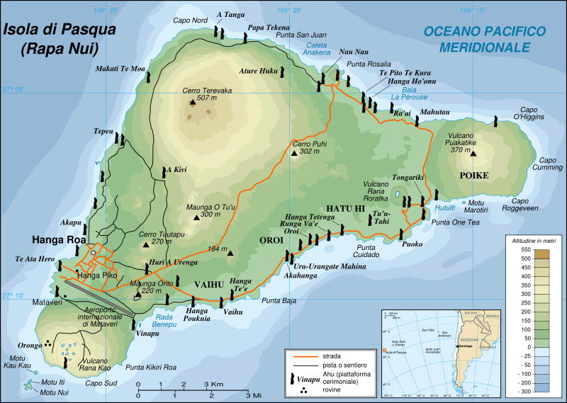
This image was selected as picture of the day on Wikimedia Commons for 1 December 2008. It was captioned as follows: English: Detailed topographic map in English of Easter Island. Other languages:
Afrikaans: Gedetaileerde topografie van Paaseiland Català: Mapa topogràfic detallat en anglès de l'Illa de Pasqua. Čeština: Detailní topografická mapa Velikonočního ostrova Eesti: Detailne inglisekeelne topograafiline kaart et:Lihavõttesaarest. English: Detailed topographic map in English of Easter Island. Esperanto: detala topografia mapo de la Paskinsulo (jen anglalingva, sed ankaŭ havebla en pluraj aliaj lingvoj) Français : Carte topographique détaillée en anglais de l'île de Pâques Italiano: Mappa topografica dell'Isola di Pasqua, Cile. Nederlands: Engelstalige gedetailleerde topografische kaart van Paaseiland Português: Mapa topográfico detalhado, em Inglês, da Ilha da Páscoa Română: Hartă topografică detaliată, în limba engleză, a insulei Paștelui. Svenska: Detaljerad topografisk karta på engelska över Påskön. Македонски: Детална топографска карта на Велигденскиот Остров на англиски. Русский: Топографическая карта Острова Пасхи 한국어: 이스터 섬의 지형도. 中文: 复活节岛地形图 中文(繁體): 復活節島地形圖 |
| Description |
English: Easter Island map in Italian language. |
| Date | |
| Source | Translation of Image:Easter Island map-fr.svg |
| Author | Eric Gaba (Sting), translated by Elborgo |
| Permission (Reusing this file) |
I, the copyright holder of this work, hereby publish it under the following license: This file is licensed under the Creative Commons Attribution-Share Alike 2.5 Generic license.
|
| Other versions |
[]
|


This W3C-unspecified vector image was created with Inkscape .

|
This SVG file contains embedded text that can be translated into your language, using any capable SVG editor, text editor or the SVG Translate tool. For more information see: About translating SVG files. |
File history
Click on a date/time to view the file as it appeared at that time.
| Date/Time | Thumbnail | Dimensions | User | Comment | |
|---|---|---|---|---|---|
| current | 10:32, 6 April 2007 | | 1,750 × 1,245 (537 KB) | Elborgo (talk | contribs) | {{Information |Description=Easter Island map in italian language |Source=Translation of Image:Easter Island map-fr.svg |Date=06 Apr 2006 |Author=User:Elborgo |Permission=cc-by-sa |other_versions=Image:Easter Island map-fr.svg [[:Image:Easte |
You cannot overwrite this file.
File usage on Commons
The following 12 pages use this file:
- File:Easter Island map-de.svg
- File:Easter Island map-en.svg
- File:Easter Island map-es.svg
- File:Easter Island map-fr.svg
- File:Easter Island map-it.svg
- File:Easter Island map-ka.svg
- File:Easter Island map-mk.svg
- File:Easter Island map-nl.svg
- File:Easter Island map-ru.svg
- File:Easter Island map-sr.svg
- File:Easter Island map-uk.svg
- Template:Other versions/Easter Island map
File usage on other wikis
The following other wikis use this file:
- Usage on it.wikipedia.org
- Usage on lmo.wikipedia.org