File:Eastern Mediterranean 1450.svg
Pāriet uz navigāciju
Pāriet uz meklēšanu

Size of this PNG preview of this SVG file: 632 × 600 pikseļi. Citi izmēri: 253 × 240 pikseļi | 506 × 480 pikseļi | 810 × 768 pikseļi | 1 079 × 1 024 pikseļi | 2 159 × 2 048 pikseļi | 2 497 × 2 369 pikseļi.
Sākotnējais fails (SVG fails, definētais izmērs 2 497 × 2 369 pikseļi, faila izmērs: 265 KB)
Captions
Captions
Pievieno vienas rindiņas aprakstu, ko šis fails attēlo
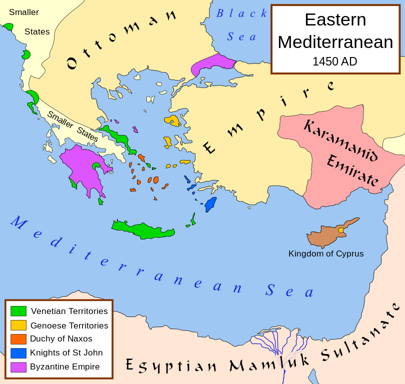
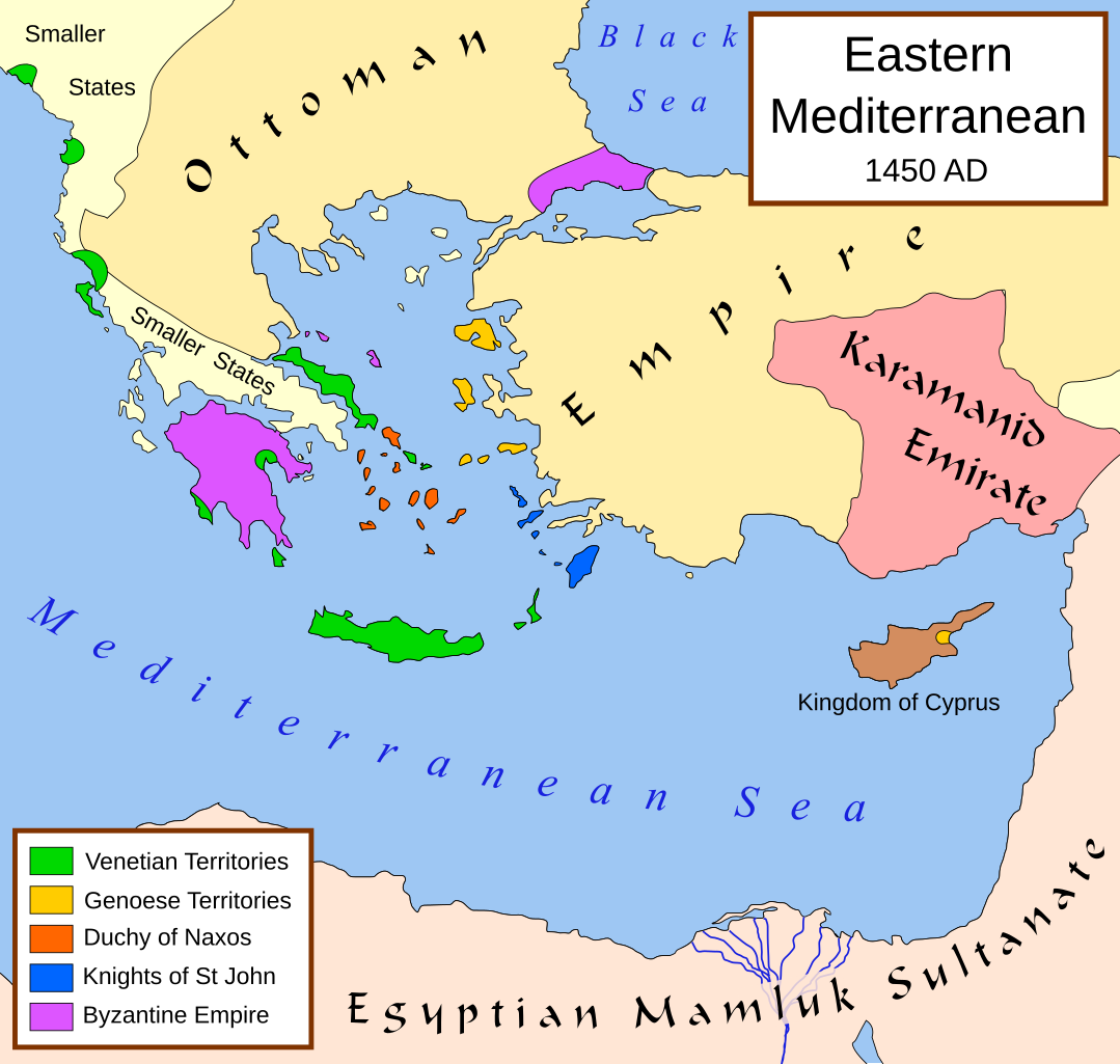
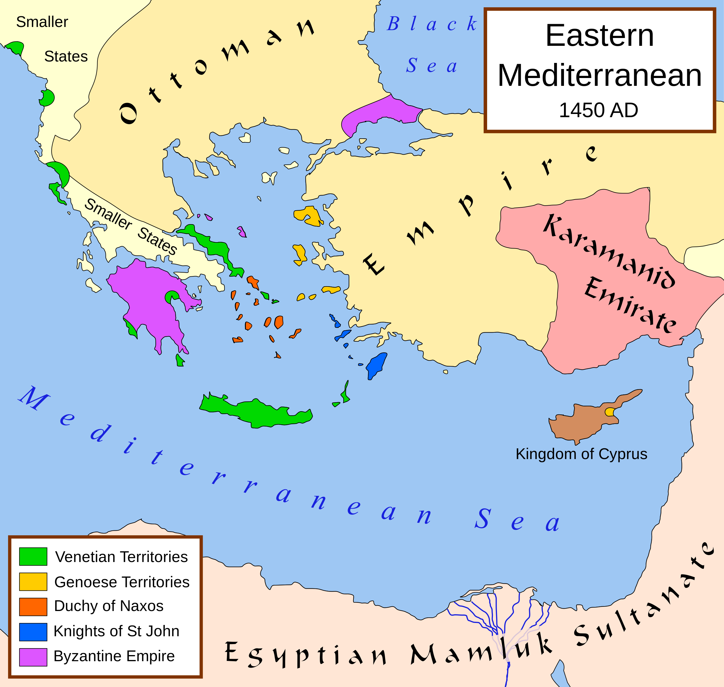
Political map of the eastern Mediterranean Sea, in 1450
Kopsavilkums
[labot šo sadaļu]| Apraksts |
English: A political map of the eastern Mediterranean Sea, in 1450. |
| Datums | |
| Avots |
Own work using:
|
| Autors | MapMaster |
| Citas versijas |
[]
|


|
This SVG file contains embedded text that can be translated into your language, using any capable SVG editor, text editor or the SVG Translate tool. For more information see: About translating SVG files. |
Licence
[labot šo sadaļu]
Es, šī darba autortiesību īpašnieks, publicēju to saskaņā ar šo licenci:
Šis fails tiek izplatīts saskaņā ar licences Creative Commons Atsauce-Līdzīgi Noteikumi 2.5 Vispārējiem noteikumiem.
- Jūs varat brīvi:
- koplietot – kopēt, izplatīt un pārraidīt darbu
- remiksēt – pielāgot darbu
- Saskaņā ar šādiem nosacījumiem:
- atsaucoties – Tev ir jānorāda autors, saite uz licenci un to, vai veiktas kādas izmaiņas. To var darīt jebkādā saprātīgā veidā, bet ne tādā, kas norādītu, ka licencētājs atbalsta tevi vai veidu, kā tu izmanto šo darbu.
- nemainot licenci – Ja tu miksē, pārveido vai izmanto materiālu, tev savs devums jāpublicē ar to pašu vai saderīgu licenci kā oriģināls.
Faila hronoloģija
Uzklikšķini uz datums/laiks kolonnā esošās saites, lai apskatītos, kā šis fails izskatījās tad.
| Datums/Laiks | Attēls | Izmēri | Dalībnieks | Komentārs | |
|---|---|---|---|---|---|
| tagadējais | 2017. gada 9. jūlijs, plkst. 12.40 | | 2 497 × 2 369 (265 KB) | Joe Roe (diskusija | devums) | removed black outer border |
| 2013. gada 6. augusts, plkst. 12.10 |  | 2 529 × 2 395 (334 KB) | Phso2 (diskusija | devums) | sporades | |
| 2013. gada 1. jūlijs, plkst. 11.25 |  | 2 529 × 2 395 (333 KB) | Phso2 (diskusija | devums) | cf disc | |
| 2007. gada 16. oktobris, plkst. 16.15 |  | 2 529 × 2 395 (333 KB) | MapMaster (diskusija | devums) | small fix | |
| 2007. gada 9. septembris, plkst. 18.56 |  | 2 529 × 2 395 (332 KB) | MapMaster (diskusija | devums) | Further slight changes, particularly Thessaloniki. | |
| 2007. gada 9. septembris, plkst. 04.23 |  | 2 529 × 2 395 (335 KB) | MapMaster (diskusija | devums) | More changes based on Alekkas' research. | |
| 2007. gada 7. septembris, plkst. 03.50 |  | 2 529 × 2 395 (348 KB) | MapMaster (diskusija | devums) | Slight modifications based on information from User:Alekkas on my talk page. | |
| 2007. gada 17. aprīlis, plkst. 03.08 |  | 2 529 × 2 395 (347 KB) | MapMaster (diskusija | devums) | Added missing text | |
| 2007. gada 14. aprīlis, plkst. 05.20 |  | 2 529 × 2 395 (321 KB) | MapMaster (diskusija | devums) | slight update | |
| 2007. gada 13. aprīlis, plkst. 20.52 |  | 2 529 × 2 395 (316 KB) | MapMaster (diskusija | devums) | A political map of the eastern Mediterranean Sea, in 1450. |
Šo failu nevar pārrakstīt.
Faila lietojums
Šo failu izmanto šajās 39 lapās:
- Atlas of the Ottoman Empire
- Eastern Mediterranean
- User:J budissin/Uploads/BiH/2017 July 1-10
- User:Kareyac/Armenia/2017 July 1-10
- User:MapMaster
- User talk:MapMaster
- File:Bütsants1450.png
- File:Duchy of Naxos locator.svg
- File:Eastern Mediterranean 1450- sr lat.svg
- File:Eastern Mediterranean 1450-hu.svg
- File:Eastern Mediterranean 1450-ru.svg
- File:Eastern Mediterranean 1450-sr.svg
- File:Eastern Mediterranean 1450-zh.svg
- File:Eastern Mediterranean 1450.svg
- File:Eastern Mediterranean 1450 -HE.svg
- File:Eastern Mediterranean 1450 - Arabic.PNG
- File:Eastern Mediterranean 1450 - HE.svg
- File:Eastern Mediterranean 1450 .svg (faila pāradresācija)
- File:Eastern Mediterranean 1450 el.svg
- File:Eastern Mediterranean 1450 es.svg
- File:Eastern Mediterranean 1450 pt.svg
- File:Eastern Mediterranean 1450 tr.png
- File:Eastern Mediterranean in 1450-hy.png
- File:Mediterraneo Orientale 1450.svg
- File:Mediterráneo Oriental 1450 d.C.svg
- File:Mediteràneo Orientàl 1450 - lmo.svg
- File:MéditerranéeOrient1450.PNG
- File:Se Easterna Wendelsæ in 1450.svg
- File:Östliches Mittelmeer 1450 DE.svg
- Template:Other versions/Eastern Mediterranean 1450
- Category:Karamanids
Globālais faila lietojums
Šīs Vikipēdijas izmanto šo failu:
- Izmantojums ar.wikipedia.org
- Izmantojums arz.wikipedia.org
- Izmantojums ast.wikipedia.org
- Izmantojums azb.wikipedia.org
- Izmantojums az.wikipedia.org
- Izmantojums be.wikipedia.org
- Izmantojums bg.wikipedia.org
- Izmantojums bn.wikipedia.org
- Izmantojums bs.wikipedia.org
- Izmantojums ca.wikipedia.org
- Izmantojums cs.wikipedia.org
- Izmantojums de.wikipedia.org
- Izmantojums el.wikipedia.org
- Izmantojums en.wikipedia.org
- Constantine XI Palaiologos
- Succession of the Roman Empire
- Karamanids
- Imbros
- Duchy of the Archipelago
- House of Lusignan
- Giosafat Barbaro
- User:MapMaster
- History of the Republic of Venice
- Knights Hospitaller
- Byzantine–Ottoman wars
- Hospitaller Rhodes
- Frankokratia
- Byzantine Empire
- Stato da Màr
- History of the Byzantine Empire
Skatīt šī faila pilno globālo izmantojumu.
Metadati
Kategorijas:
- Maps of the history of the Ottoman Empire in the 1450s
- Maps of the history of Greece
- Orders of chivalry
- Stato da Màr
- Maps of the Republic of Venice
- Maps of the Republic of Genoa
- Maps of the Duchy of the Archipelago
- Maps of the Order of Saint John of Jerusalem
- Maps of the Karamanids
- Greece in the 15th century
- Turkey in the 15th century
- Egypt in the 15th century
- 1450