File:Eastside Project (April 19, 2017) (34163415785).jpg
Jump to navigation
Jump to search

Size of this preview: 800 × 350 pixels. Other resolutions: 320 × 140 pixels | 640 × 280 pixels | 1,024 × 448 pixels | 1,280 × 560 pixels | 3,000 × 1,312 pixels.
Original file (3,000 × 1,312 pixels, file size: 1.13 MB, MIME type: image/jpeg)
Captions
Captions
Add a one-line explanation of what this file represents
Summary
[edit]_(34163415785).jpg&action=edit§ion=1)
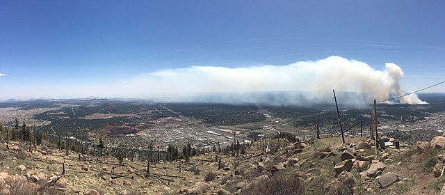
| Description | View from Mount Elden of the prescribed burn near the Pine Canyon subdivision south of Flagstaff on April 19, 2017. Photo by Wes Hall. Credit: U.S. Forest Service Coconino National Forest. For more information about the Spring 2017 prescribed burn season, visit Inciweb: inciweb.nwcg.gov/incident/5047/ |
| Date | |
| Source | Eastside Project (April 19, 2017) |
| Author | Coconino National Forest |
| Camera location | | View this and other nearby images on: OpenStreetMap |
|---|
_(34163415785).jpg¶ms=035.240508_N_-111.597498_E_globe:Earth_type:camera_source:Flickr_&language=en)
Licensing
[edit]_(34163415785).jpg&action=edit§ion=2)
This image is a work of the Forest Service of the United States Department of Agriculture. As a work of the U.S. federal government, the image is in the public domain.
|
| This image, originally posted to Flickr, was reviewed on 25 May 2017 by the administrator or reviewer Leoboudv, who confirmed that it was available on Flickr under the stated license on that date. |
File history
Click on a date/time to view the file as it appeared at that time.
| Date/Time | Thumbnail | Dimensions | User | Comment | |
|---|---|---|---|---|---|
| current | 23:36, 17 May 2017 | | 3,000 × 1,312 (1.13 MB) | Ser Amantio di Nicolao (talk | contribs) | Transferred from Flickr via Flickr2Commons |
You cannot overwrite this file.
File usage on Commons
There are no pages that use this file.
_(34163415785).jpg&oldid=619889693)