File:Echus Chasma, annotated nadir view ESA227010.jpg

Original file (2,482 × 1,500 pixels, file size: 987 KB, MIME type: image/jpeg)
Captions
Captions
Summary[edit]
| Description |
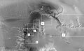
English: The High-Resolution Stereo Camera (HRSC) on board ESA’s Mars Express has returned images of Echus Chasma, one of the largest water source regions on the Red Planet. Echus Chasma is the source region of Kasei Valles which extends 3000 km to the north. The data was acquired on 25 September 2005. The pictures are centred at about 1° north and 278° east and have a ground resolution of approximately 17 m/pixel.
The images show valleys that are about 10 km long and 1000 m deep (1). The main valley, Kasei Valles, is about 4 km in depth. The smaller valleys, also called sapping canyons, originate from the discharge of groundwater. A prominent, sickle-shaped (about 25 km-long) dike is visible in the centre of the image (2). Dikes form when magma rises up through fissures in the overlying rock or penetrates existing rock layers. This indicates that the region must have been volcanically active in the past. The magmatic rock is usually quite resistant to weathering and is able to endure erosion. Two impact craters with a diameter of approximately 8 km are located south-east of the dike (3). The eastern crater was partly eroded as the valley formed. A large portion of the crater collapsed into the valley and its debris was removed. The dark material shows a network of light-coloured, incised valleys (4) that look similar to drainage networks known on Earth. It is still debated whether the valleys originate from precipitation, groundwater springs or liquid or magma flows on the surface. An impressive cliff, up to 4000 m high, is located in the eastern part of Echus Chasma(5). Gigantic water falls may once have plunged over these cliffs on to the valley floor. The remarkably smooth valley floor was later flooded by basaltic lava. |
| Date | |
| Source | http://www.esa.int/spaceinimages/Images/2008/07/Echus_Chasma_annotated_nadir_view |
| Author | European Space Agency |
| Permission (Reusing this file) |
ESA/DLR/FU Berlin (G. Neukum),CC BY-SA 3.0 IGO |
| Other versions |
|
| Title | Echus Chasma, annotated nadir view |
| Mission | Mars Express |
| Activity | Space Science |
Licensing[edit]
- You are free:
- to share – to copy, distribute and transmit the work
- to remix – to adapt the work
- Under the following conditions:
- attribution – You must give appropriate credit, provide a link to the license, and indicate if changes were made. You may do so in any reasonable manner, but not in any way that suggests the licensor endorses you or your use.
- share alike – If you remix, transform, or build upon the material, you must distribute your contributions under the same or compatible license as the original.
File history
Click on a date/time to view the file as it appeared at that time.
| Date/Time | Thumbnail | Dimensions | User | Comment | |
|---|---|---|---|---|---|
| current | 17:06, 24 May 2017 | | 2,482 × 1,500 (987 KB) | Fæ (talk | contribs) | European Space Agency, Id 227010, http://www.esa.int/spaceinimages/Images/2008/07/Echus_Chasma_annotated_nadir_view, User:Fæ/Project_list/ESA |
You cannot overwrite this file.
File usage on Commons
The following page uses this file: