File:Eichstätt Le Rouge 1757.jpg
Jump to navigation
Jump to search
Size of this preview: 795 × 600 pixels. Other resolutions: 318 × 240 pixels | 636 × 480 pixels | 1,018 × 768 pixels | 1,280 × 966 pixels | 1,988 × 1,500 pixels.
Original file (1,988 × 1,500 pixels, file size: 1.27 MB, MIME type: image/jpeg)
Captions
Captions
Add a one-line explanation of what this file represents
Summary
[edit]
| Description |
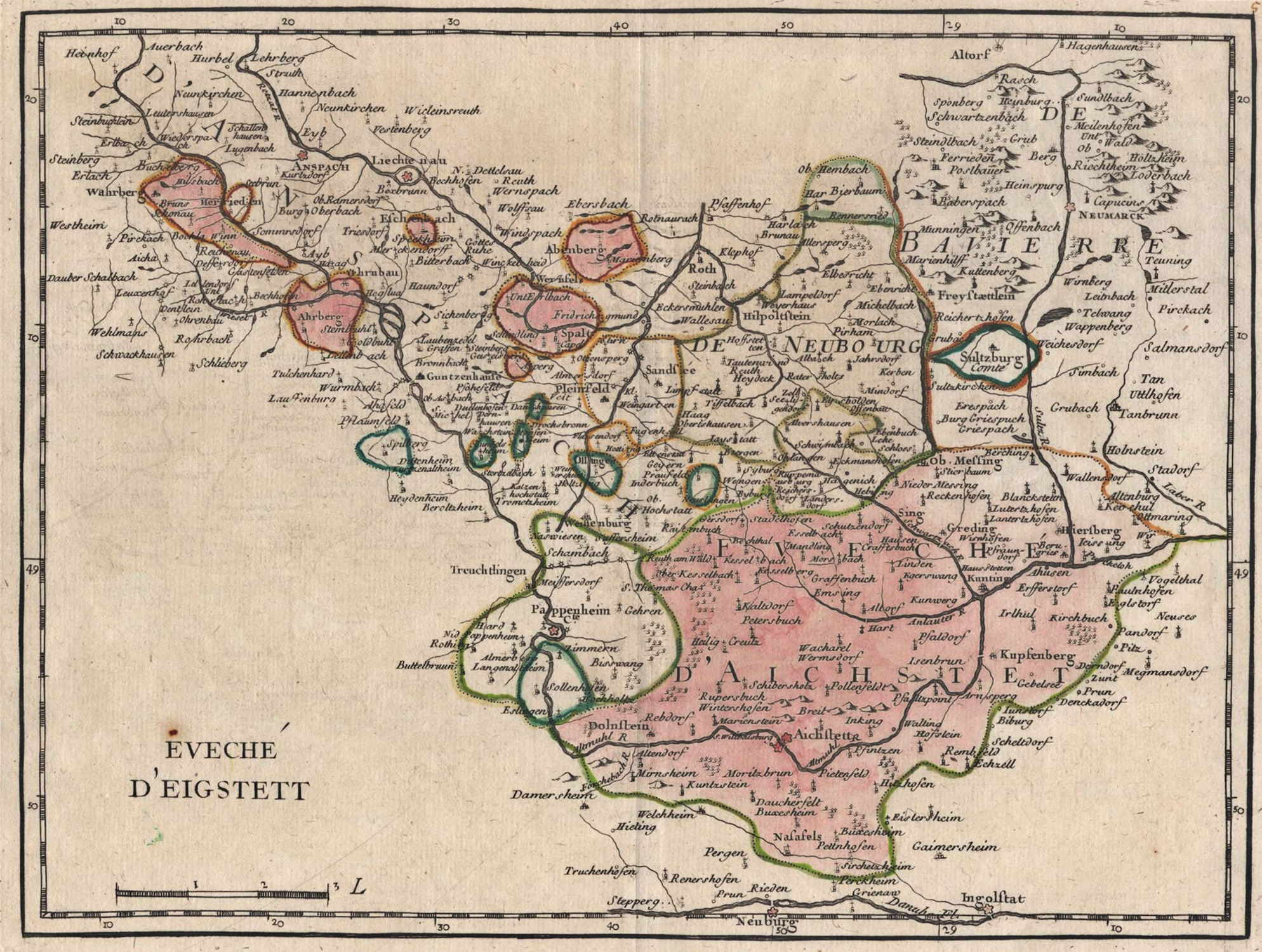
English: Map by French cartographer Georges-Louis Le Rouge showing the Bishopric of Eichstätt ("Eveché D'Eigstett").
This map, published in 1757, shows both the bishop's Hochstift or prince-bishopric (the areas in pink) and his diocese (the rest of the map where the parish churches are indicated with a symbol with a cross). As can be seen on this map, the diocese extended over parts of the Duchy of Bavaria, the Palatinate-Newburg and the Margraviate of Ansbach. Français : Carte de l'Évêché d'Eichstätt publiée par Georges-Louis Le Rouge en 1757. Cette carte présente à la fois le Hochstift de l'évêque (sa principauté épiscopale, en rose) dont il est le prince temporel, et son diocèse (le reste de la carte parsemé d'églises paroissiales représentées par un symbole surmonté d'une croix). Comme on peut le constater d'après cette carte, le diocèse s'étendait sur certaines parties du Duché de Bavière, du Palatinat-Neuburg et du Margraviat d'Ansbach. |
| Date | |
| Source | Moll's map collection |
| Author | Georges-Louis Le Rouge (1712–1790) |
Licensing
[edit]
|
This work is in the public domain in its country of origin and other countries and areas where the copyright term is the author's life plus 100 years or fewer. | |
| This file has been identified as being free of known restrictions under copyright law, including all related and neighboring rights. | |
File history
Click on a date/time to view the file as it appeared at that time.
| Date/Time | Thumbnail | Dimensions | User | Comment | |
|---|---|---|---|---|---|
| current | 15:51, 29 July 2018 | | 1,988 × 1,500 (1.27 MB) | Lubiesque (talk | contribs) | User created page with UploadWizard |
You cannot overwrite this file.
File usage on Commons
There are no pages that use this file.