File:Eifel - Deutsche Mittelgebirge, Serie A-de.png
Fitxer original (2.500 × 2.600 píxels, mida del fitxer: 9,83 Mo, tipus MIME: image/png)
Llegendes
Llegendes
Resum[modifica]
| Descripció |
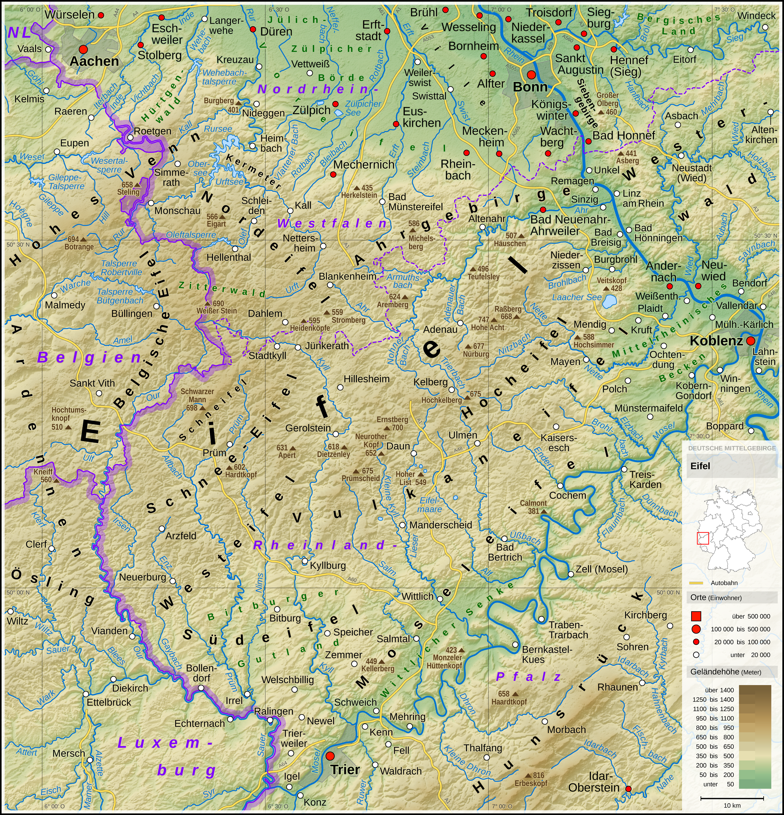
English: Topographic map of the Eifel
Deutsch: Topografische Karte der Eifel |
||||||||||||||||||
| Data | |||||||||||||||||||
| Font |
Own work using: |
||||||||||||||||||
| Autor | Thoroe | ||||||||||||||||||
| Altres versions |
 Topographic maps of German low mountain ranges (A series)
This map series aims to show the major low mountain ranges of Germany in a uniform design. All maps are created on the same scale, and the background reliefs base upon the same color scheme. The reliefs are also available as separate files. You can find the making-of one of the maps in the German language Wikipedia (German only).
|
||||||||||||||||||


_-_Deutsche_Mittelgebirge,_Serie_A-de.png)
_-_Deutsche_Mittelgebirge,_Serie_A-de.png)
_-_Deutsche_Mittelgebirge,_Serie_A-de.png)
_-_Deutsche_Mittelgebirge,_Serie_A-de.png)
_-_Deutsche_Mittelgebirge,_Serie_A-de.png)
_-_Deutsche_Mittelgebirge,_Serie_A-de.png)
_-_Deutsche_Mittelgebirge,_Serie_A-de.png)
_-_Deutsche_Mittelgebirge,_Serie_A-de.png)
_-_Deutsche_Mittelgebirge,_Serie_A-de.png)
_-_Deutsche_Mittelgebirge,_Serie_A-de.png)
_-_Deutsche_Mittelgebirge,_Serie_A-de.png)
_-_Deutsche_Mittelgebirge,_Serie_A-de.png)
_-_Deutsche_Mittelgebirge,_Serie_A-de.png)
_-_Deutsche_Mittelgebirge,_Serie_A-de.png)
_-_Deutsche_Mittelgebirge,_Serie_A-de.png)
_-_Deutsche_Mittelgebirge,_Serie_A-de.png)
_-_Deutsche_Mittelgebirge,_Serie_A-de.png)
_-_Deutsche_Mittelgebirge,_Serie_A-de.png)
_-_Deutsche_Mittelgebirge,_Serie_A-de.png)
_-_Deutsche_Mittelgebirge,_Serie_A-de.png)
_-_Deutsche_Mittelgebirge,_Serie_A-de.png)
_-_Deutsche_Mittelgebirge,_Serie_A-de.png)
_-_Deutsche_Mittelgebirge,_Serie_A-de.png)
_-_Deutsche_Mittelgebirge,_Serie_A-de.png)
_-_Deutsche_Mittelgebirge,_Serie_A-de.png)
_-_Deutsche_Mittelgebirge,_Serie_A-de.png)
_-_Deutsche_Mittelgebirge,_Serie_A-de.png)
_-_Deutsche_Mittelgebirge,_Serie_A-de.png)
_-_Deutsche_Mittelgebirge,_Serie_A-de.png)
_-_Deutsche_Mittelgebirge,_Serie_A-de.png)
_-_Deutsche_Mittelgebirge,_Serie_A-de.png)
_-_Deutsche_Mittelgebirge,_Serie_A-de.png)
| This work contains information from OpenStreetMap, which is made available under the Open Database License (ODbL).
The ODbL does not require any particular license for maps produced from ODbL data. Prior to 1 August 2020, map tiles produced by the OpenStreetMap Foundation were licensed under the CC-BY-SA-2.0 license. Maps produced by other people may be subject to other licences. |

|
This map has been made or improved in the German Kartenwerkstatt (Map Lab). You can propose maps to improve as well.
|
Llicència[modifica]
- Sou lliure de:
- compartir – copiar, distribuir i comunicar públicament l'obra
- adaptar – fer-ne obres derivades
- Amb les condicions següents:
- reconeixement – Heu de donar la informació adequada sobre l'autor, proporcionar un enllaç a la llicència i indicar si s'han realitzat canvis. Podeu fer-ho amb qualsevol mitjà raonable, però de cap manera no suggereixi que l'autor us dóna suport o aprova l'ús que en feu.
- compartir igual – Si modifiqueu, transformeu, o generareu amb el material, haureu de distribuir les vostres contribucions sota una llicència similar o una de compatible com l'original
| Anotacions | Aquesta imatge té anotacions: Vegeu-les a Commons |
Historial del fitxer
Cliqueu una data/hora per veure el fitxer tal com era aleshores.
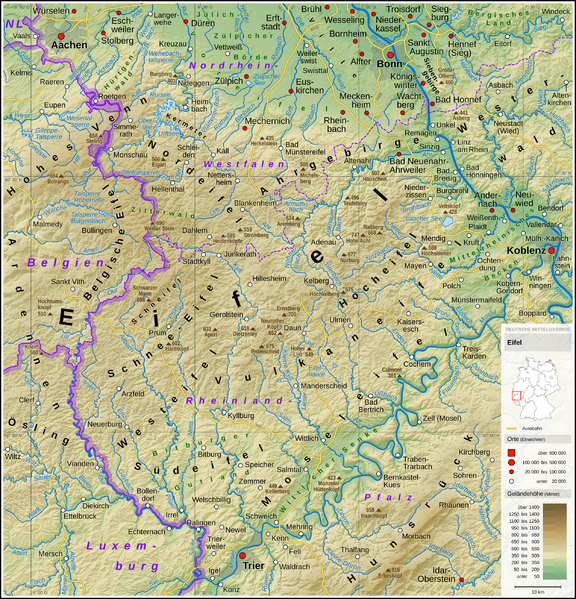
| Data/hora | Miniatura | Dimensions | Usuari/a | Comentari | |
|---|---|---|---|---|---|
| actual | 10:53, 13 maig 2017 | | 2.500 × 2.600 (9,83 Mo) | Thoroe (discussió | contribucions) | Brohlbach (Mosel) korr. |
| 23:05, 10 maig 2017 |  | 2.500 × 2.600 (9,82 Mo) | Thoroe (discussió | contribucions) | + Stadtkyll | |
| 13:56, 7 maig 2017 |  | 2.500 × 2.600 (9,82 Mo) | Thoroe (discussió | contribucions) | 1st revision | |
| 20:37, 4 maig 2017 |  | 2.500 × 2.600 (9,82 Mo) | Thoroe (discussió | contribucions) | {{Information |Description ={{en|1=Topographic map of the Eifel}} {{de|1=Topografische Karte der Eifel}} |Source ={{Own using}} *[http://gmt.soest.hawaii.edu Generic Mapping Tools (GMT)] with [http://dds.cr.usgs.g... |
No podeu sobreescriure aquest fitxer.
Ús del fitxer
Les 51 pàgines següents utilitzen aquest fitxer:
- File:Bayerischer Wald (Relief) - Deutsche Mittelgebirge, Serie A-de.png
- File:Bayerischer Wald (Relief und Gewässer) - Deutsche Mittelgebirge, Serie A-de.png
- File:Bayerischer Wald - Deutsche Mittelgebirge, Serie A-de.png
- File:Deutsche Mittelgebirge, Serie A - Abdeckung.svg
- File:Eifel (Relief) - Deutsche Mittelgebirge, Serie A-de.png
- File:Eifel (Relief und Gewässer) - Deutsche Mittelgebirge, Serie A-de.png
- File:Eifel - Deutsche Mittelgebirge, Serie A-de.png
- File:Harz (Relief) - Deutsche Mittelgebirge, Serie A-de.png
- File:Harz (Relief und Gewässer) - Deutsche Mittelgebirge, Serie A-de.png
- File:Harz - Deutsche Mittelgebirge, Serie A-de.png
- File:Hunsrück (Relief) - Deutsche Mittelgebirge, Serie A-de.png
- File:Hunsrück (Relief und Gewässer) - Deutsche Mittelgebirge, Serie A-de.png
- File:Hunsrück - Deutsche Mittelgebirge, Serie A-de.png
- File:Oberpfälzer Wald (Relief) - Deutsche Mittelgebirge, Serie A-de.png
- File:Oberpfälzer Wald (Relief und Gewässer) - Deutsche Mittelgebirge, Serie A-de.png
- File:Oberpfälzer Wald - Deutsche Mittelgebirge, Serie A-de.png
- File:Odenwald (Relief) - Deutsche Mittelgebirge, Serie A-de.png
- File:Odenwald (Relief und Gewässer) - Deutsche Mittelgebirge, Serie A-de.png
- File:Odenwald - Deutsche Mittelgebirge, Serie A-de.png
- File:Rhön (Relief) - Deutsche Mittelgebirge, Serie A-de.png
- File:Rhön (Relief und Gewässer) - Deutsche Mittelgebirge, Serie A-de.png
- File:Rhön - Deutsche Mittelgebirge, Serie A-de.png
- File:Rothaargebirge (Relief) - Deutsche Mittelgebirge, Serie A-de.png
- File:Rothaargebirge (Relief und Gewässer) - Deutsche Mittelgebirge, Serie A-de.png
- File:Rothaargebirge - Deutsche Mittelgebirge, Serie A-de.png
- File:Schwarzwald (Relief) - Deutsche Mittelgebirge, Serie A-de.png
- File:Schwarzwald (Relief und Gewässer) - Deutsche Mittelgebirge, Serie A-de.png
- File:Schwarzwald - Deutsche Mittelgebirge, Serie A-de.png
- File:Schwäbische Alb (Relief) - Deutsche Mittelgebirge, Serie A-de.png
- File:Schwäbische Alb (Relief und Gewässer) - Deutsche Mittelgebirge, Serie A-de.png
- File:Schwäbische Alb - Deutsche Mittelgebirge, Serie A-de.png
- File:Spessart (Relief) - Deutsche Mittelgebirge, Serie A-de.png
- File:Spessart (Relief und Gewässer) - Deutsche Mittelgebirge, Serie A-de.png
- File:Spessart - Deutsche Mittelgebirge, Serie A-de.png
- File:Taunus (Relief) - Deutsche Mittelgebirge, Serie A-de.png
- File:Taunus (Relief und Gewässer) - Deutsche Mittelgebirge, Serie A-de.png
- File:Taunus - Deutsche Mittelgebirge, Serie A-de.png
- File:Teutoburger Wald (Relief) - Deutsche Mittelgebirge, Serie A-de.png
- File:Teutoburger Wald (Relief und Gewässer) - Deutsche Mittelgebirge, Serie A-de.png
- File:Teutoburger Wald - Deutsche Mittelgebirge, Serie A-de.png
- File:Thüringer Wald (Relief) - Deutsche Mittelgebirge, Serie A-de.png
- File:Thüringer Wald (Relief und Gewässer) - Deutsche Mittelgebirge, Serie A-de.png
- File:Thüringer Wald - Deutsche Mittelgebirge, Serie A-de.png
- File:Topografische Karte der Ahr.PNG
- File:Vogelsberg (Relief) - Deutsche Mittelgebirge, Serie A-de.png
- File:Vogelsberg (Relief und Gewässer) - Deutsche Mittelgebirge, Serie A-de.png
- File:Vogelsberg - Deutsche Mittelgebirge, Serie A-de.png
- File:Westerwald (Relief) - Deutsche Mittelgebirge, Serie A-de.png
- File:Westerwald (Relief und Gewässer) - Deutsche Mittelgebirge, Serie A-de.png
- File:Westerwald - Deutsche Mittelgebirge, Serie A-de.png
- Template:Topographic maps of German low mountain ranges (Mittelgebirge), A series
Ús global del fitxer
Utilització d'aquest fitxer en altres wikis:
- Utilització a arz.wikipedia.org
- Utilització a bn.wikipedia.org
- Utilització a ca.wikipedia.org
- Utilització a da.wikipedia.org
- Utilització a de.wikipedia.org
- Eifel
- Vulkaneifel
- Wittlicher Senke
- Winterspelt (Andersch)
- Schneifel
- Östliche Hocheifel
- Ahrgebirge
- Rureifel
- Nordeifel
- Südeifel
- Zitterwald
- Portal:Eifel
- Kermeter
- Hürtgenwald (Forst)
- Wikipedia:Kartenwerkstatt/Kartenwünsche
- Moseleifel
- Liste von Bergen und Erhebungen der Eifel
- Voreifel
- Liste der naturräumlichen Einheiten in Rheinland-Pfalz
- Benutzer:Thoroe
- Bitburger Gutland
- Wikipedia:Kartenwerkstatt/Archiv/2017-05
- Prümscheid (Naturraum)
- Benutzer:Thoroe/Making of Thüringer Wald
- Utilització a de.wiktionary.org
- Utilització a el.wikipedia.org
- Utilització a en.wikipedia.org
- Utilització a en.wikivoyage.org
- Utilització a eo.wikipedia.org
- Utilització a es.wikipedia.org
- Utilització a et.wikipedia.org
- Utilització a fa.wikipedia.org
- Utilització a fi.wikipedia.org
- Utilització a frr.wikipedia.org
- Utilització a fr.wikipedia.org
Vegeu més usos globals d'aquest fitxer.