File:Eighty Mile Beach, Western Australia (MODIS).jpg
Jump to navigation
Jump to search

Size of this preview: 788 × 600 pixels. Other resolutions: 315 × 240 pixels | 631 × 480 pixels | 1,009 × 768 pixels | 1,280 × 974 pixels | 1,830 × 1,393 pixels.
Original file (1,830 × 1,393 pixels, file size: 157 KB, MIME type: image/jpeg)
Captions
Captions
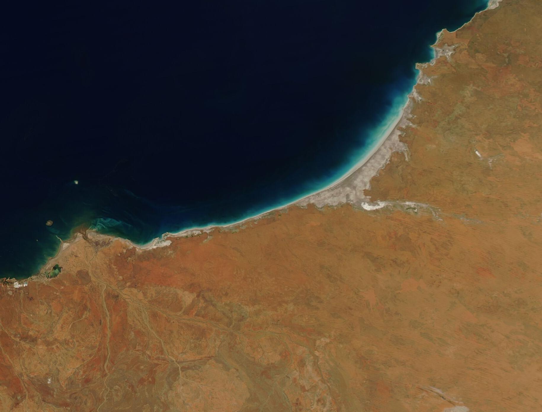
On October 7, 2022, the Moderate Resolution Imaging Spectroradiometer (MODIS) on board NASA’s Aqua satellite acquired a true-color image of Eighty Mile Beach.
Summary
[edit].jpg&action=edit§ion=1)
| Description |
English: Sitting between the Indian Ocean and the harsh environment of the Great Sandy Desert, a gorgeous bit of beach acts like an oasis, providing a home for abundant wildlife as well an attraction for flocks of tourists each year. According to the Government of Western Australia’s Explore Parks WA website, Eighty Mile Beach is 220 km of uninterrupted white sand, turquoise waters, mudflats, and mangroves that is ideal for anglers, campers, four-wheel drivers, campers, and bird watchers. The unique and important ecosystem is recognized by International BirdLife as an International Bird and Biodiversity Area (IBA) and is recognized as an area of international importance under the Ramsar Convention on Wetlands. More than 400,000 shorebirds rest here on migration and Flatback Turtles—a species found only in Australia—nest on the beach between October and through February.
On October 7, 2022, the Moderate Resolution Imaging Spectroradiometer (MODIS) on board NASA’s Aqua satellite acquired a true-color image of Eighty Mile Beach. The beach stretches from about Cape Keraudren to Cape Bossut, and actually measures roughly 85 miles (140 km) long. A halo of light blue tints the waters of the Indian Ocean, just off the beach. This is likely caused by sediment washed into the waters by tidal action. A bright white area extending from the Great Sandy Desert (inland) westward to Eighty Mile Beach is the Gascoyne River, a river that holds water roughly 120 days of each year then becomes a dry bed for the remainder of the year. |
||
| Date | Taken on 7 October 2022 | ||
| Source |
Eighty Mile Beach, Western Australia (direct link)
|
||
| Author | MODIS Land Rapid Response Team, NASA GSFC |
| This media is a product of the Aqua mission Credit and attribution belongs to the mission team, if not already specified in the "author" row |
Licensing
[edit].jpg&action=edit§ion=2)
| This file is in the public domain in the United States because it was solely created by NASA. NASA copyright policy states that "NASA material is not protected by copyright unless noted". (See Template:PD-USGov, NASA copyright policy page or JPL Image Use Policy.) | ||
 |
Warnings:
|
File history
Click on a date/time to view the file as it appeared at that time.
| Date/Time | Thumbnail | Dimensions | User | Comment | |
|---|---|---|---|---|---|
| current | 00:20, 13 September 2023 | | 1,830 × 1,393 (157 KB) | OptimusPrimeBot (talk | contribs) | #Spacemedia - Upload of http://modis.gsfc.nasa.gov/gallery/images/image10112022_250m.jpg via Commons:Spacemedia |
You cannot overwrite this file.
File usage on Commons
There are no pages that use this file.
.jpg&oldid=801223828)