File:EisrandlagenNorddeutschland.jpg
Jump to navigation
Jump to search
No higher resolution available.
EisrandlagenNorddeutschland.jpg (474 × 405 pixels, file size: 45 KB, MIME type: image/jpeg)
Captions
Captions
Add a one-line explanation of what this file represents
| Description |
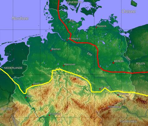
Deutsch: Grobschematische Darstellung der jeweils maximalen Eisrandlagen (Vergletscherungen) der beiden letzten großen Eiszeiten in Norddeutschland. Gelbe Linie: Drenthestadium der de:Saaleeiszeit, rote Linie: Brandenburger Stadium der de:Weichseleiszeit.
|
| Date | 13 April 2006 (original upload date) |
| Source | Eigene Graphik auf der Grundlage der Wikipedia-Abbildung de:Bild:Deutschland topo.jpg (Ausschnitt). |
| Author | The original uploader was Fice at German Wikipedia. |
Licensing[edit]

|
Permission is granted to copy, distribute and/or modify this document under the terms of the GNU Free Documentation License, Version 1.2 or any later version published by the Free Software Foundation; with no Invariant Sections, no Front-Cover Texts, and no Back-Cover Texts. A copy of the license is included in the section entitled GNU Free Documentation License. |
| This file is licensed under the Creative Commons Attribution-Share Alike 3.0 Unported license. | ||
| ||
| This licensing tag was added to this file as part of the GFDL licensing update. |
Original upload log[edit]
The original description page was here. All following user names refer to de.wikipedia.
- 2006-04-13 10:33 Fice 474×405× (46232 bytes) *Beschreibung: Grobschematische Darstellung der jeweils maximalen Eisrandlagen (Vergletscherungen) der beiden letzten großen Eiszeiten in Norddeutschland. '''Gelbe''' Linie: Drenthe-Stadium der '''[[Saale-Eiszeit]]''', '''rote''' Linie: Brandenburger Sta
File history
Click on a date/time to view the file as it appeared at that time.
| Date/Time | Thumbnail | Dimensions | User | Comment | |
|---|---|---|---|---|---|
| current | 15:39, 18 December 2008 | | 474 × 405 (45 KB) | TUBS (talk | contribs) | {{Information |Description={{de|Grobschematische Darstellung der jeweils maximalen Eisrandlagen (Vergletscherungen) der beiden letzten großen Eiszeiten in Norddeutschland. '''Gelbe''' Linie: Drenthestadium der '''de:Saaleeiszeit''', '''rote''' Linie |
You cannot overwrite this file.
File usage
The following page uses this file:
Global file usage
The following other wikis use this file:
- Usage on da.wikipedia.org
- Usage on de.wikipedia.org
- Usage on en.wikipedia.org
- Usage on es.wikipedia.org
- Usage on fi.wikipedia.org
- Usage on fr.wikipedia.org
- Usage on it.wikipedia.org
- Usage on ja.wikipedia.org
- Usage on ka.wikipedia.org
- Usage on lb.wikipedia.org
- Usage on nn.wikipedia.org
- Usage on ro.wikipedia.org
- Usage on ru.wikipedia.org
- Usage on sq.wikipedia.org
- Usage on tr.wikipedia.org
- Usage on uk.wikipedia.org