File:Elbe tributaries discharge diagram.svg
Zur Navigation springen
Zur Suche springen

Größe der PNG-Vorschau dieser SVG-Datei: 800 × 600 Pixel. Weitere Auflösungen: 320 × 240 Pixel | 640 × 480 Pixel | 1.024 × 768 Pixel | 1.280 × 960 Pixel | 2.560 × 1.920 Pixel | 1.600 × 1.200 Pixel.
Originaldatei (SVG-Datei, Basisgröße: 1.600 × 1.200 Pixel, Dateigröße: 23 KB)
Bildtexte
Kurzbeschreibungen
Ergänze eine einzeilige Erklärung, was diese Datei darstellt.
| Beschreibung |
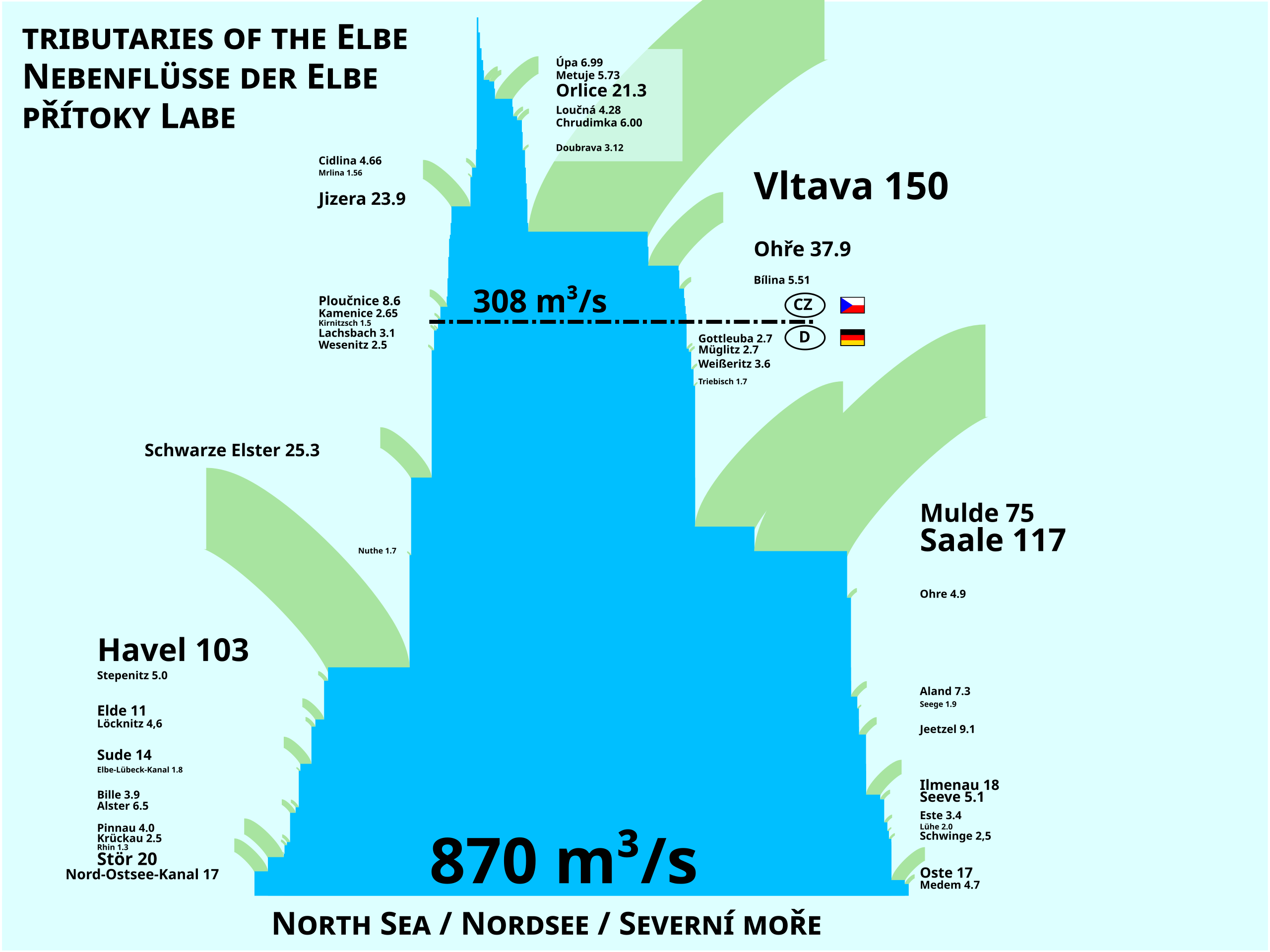
Čeština: Schéma řeky Labe a jejích přítoků z hlediska průměrného průtoku (MQ) v m³/s.
English: Scheme of the Elbe River and its tributaries showing average discharge (MQ) in m³/s.
Deutsch: Schema der Elbe und ihrer Zuflüsse. Gezeigt wird der durchschnittliche Zufluss in m³/s. |
| Datum | |
| Quelle | Eigenes Werk |
| Urheber | Miaow |
| Andere Versionen |
|
| SVG‑Erstellung | Diese Landkarte wurde mit einem unbekannten SVG-Editor erstellt. |

| Ich, der Urheberrechtsinhaber dieses Werkes, veröffentliche es als gemeinfrei. Dies gilt weltweit. In manchen Staaten könnte dies rechtlich nicht möglich sein. Sofern dies der Fall ist: Ich gewähre jedem das bedingungslose Recht, dieses Werk für jedweden Zweck zu nutzen, es sei denn, Bedingungen sind gesetzlich erforderlich. |
Dateiversionen
Klicke auf einen Zeitpunkt, um diese Version zu laden.
| Version vom | Vorschaubild | Maße | Benutzer | Kommentar | |
|---|---|---|---|---|---|
| aktuell | 11:59, 24. Nov. 2011 | | 1.600 × 1.200 (23 KB) | Miaow Miaow (Diskussion | Beiträge) | fmt (text position) |
| 21:47, 23. Nov. 2011 |  | 1.600 × 1.200 (23 KB) | Miaow Miaow (Diskussion | Beiträge) | typo (caps.) | |
| 21:43, 23. Nov. 2011 |  | 1.600 × 1.200 (23 KB) | Miaow Miaow (Diskussion | Beiträge) | {{Information |Description={{cs|Schéma řeky Labe a jejích přítoků z hlediska průměrného průtoku (MQ) v m³/s.}} {{en|Scheme of the Elbe River and its tributaries showing average discharge (MQ) in m³/s.}} |Source= { |
Du kannst diese Datei nicht überschreiben.
Dateiverwendung
Die folgende Seite verwendet diese Datei:
Globale Dateiverwendung
Die nachfolgenden anderen Wikis verwenden diese Datei:
- Verwendung auf ar.wikipedia.org
- Verwendung auf bh.wikipedia.org
- Verwendung auf ca.wikipedia.org
- Verwendung auf cs.wikipedia.org
- Verwendung auf de.wikipedia.org
- Verwendung auf en.wikipedia.org
- Verwendung auf es.wikipedia.org
- Verwendung auf fa.wikipedia.org
- Verwendung auf fi.wikipedia.org
- Verwendung auf frr.wikipedia.org
- Verwendung auf fr.wikipedia.org
- Verwendung auf fy.wikipedia.org
- Verwendung auf it.wikipedia.org
- Verwendung auf lv.wikipedia.org
- Verwendung auf ml.wikipedia.org
- Verwendung auf mr.wikipedia.org
- Verwendung auf nl.wikipedia.org
- Verwendung auf no.wikipedia.org
- Verwendung auf pl.wikipedia.org
- Verwendung auf ru.wikipedia.org
- Verwendung auf sk.wikipedia.org
- Verwendung auf zh.wikipedia.org
Metadaten
Kategorien:
- Diagrams of the Elbe
- Maps of the Elbe in Czechia
- Bílina (river)
- Diagrams about the Cidlina
- Diagrams about the Chrudimka
- Diagrams about the Doubrava River
- Jizera (river)
- Kamenice (Elbe tributary)
- Diagrams about the Loučná
- Metuje
- Mrlina
- Maps of the Ohře
- Orlice
- Ploučnice
- Diagrams about the Úpa
- Vltava
- Alster (River)
- Bille
- Elbe-Lübeck Canal
- Elde
- Este (Elbe)
- Gottleuba
- Maps of the Havel
- Ilmenau (Elbe)
- Jeetze
- Kiel Canal
- Kirnitzsch
- Löcknitz (river)
- Lühe (river)
- Maps of the Elbe in Germany
- Medem
- Mulde
- Ohre
- Oste
- Pinnau
- River discharge statistics
- Saale
- Schwarze Elster
- Seeve
- Stepenitz (Brandenburg)
- Stör
- Sude
- Tributaries of the Elbe
- Triebisch
- Weißeritz
- Wesenitz
- 2010s maps of Germany
- Rivers in 2011
- Trilingual Czech-English-German signs
- Czech-language diagrams
- English-language diagrams
- German-language diagrams