File:Empire akkad.svg

原始文件 (SVG文件,尺寸为1,475 × 1,149像素,文件大小:2.34 MB)
说明
说明
摘要
[编辑]
|
This SVG file contains embedded text that can be translated into your language, using any capable SVG editor, text editor or the SVG Translate tool. For more information see: About translating SVG files. |
| 描述 |
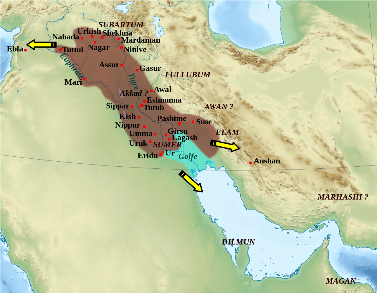
English: Mapa que mostra l'extensió aproximada de l'imperi Accadi durant el regnat de Narâm-Sîn (2254-2218 a.C. en la cronologia breu). Français : Carte de l'extension approximative de l'empire d'Akkad sous le règne de Narâm-Sîn (2254-2218 av. J.-C. selon la chronologie moyenne), et des directions des campagnes militaires extérieures. Sources : B. Lafont et M. Sauvage dans M. Sauvage (dir.), Atlas historique du Proche-Orient ancien, Paris, Les Belles Lettres, 2020, p. 70 ; P. Michalowski, « The Kingdom of Akkad in Contact with the World », dans The Oxford History of the Ancient Near East, Volume 1: From the Beginnings to Old Kingdom Egypt and the Dynasty of Akkad, New York, Oxford University Press, 2020, p. 688 fig. 10.1. |
| 日期 | (UTC) |
| 来源 | |
| 作者 |
|
| 其他版本 |
File:Empire akkad.svg has 2 translations.
Other related versions: []
|


| 相机位置 | | 在以下服务上查看本图像和附近其他图像: OpenStreetMap |
|---|
|
|
This SVG file contains embedded text that can be translated into your language, using any capable SVG editor, text editor or the SVG Translate tool. For more information see: About translating SVG files. |
This file is translated using SVG <switch> elements. All translations are stored in the same file! Learn more.
For most Wikipedia projects, you can embed the file normally (without a To translate the text into your language, you can use the SVG Translate tool. Alternatively, you can download the file to your computer, add your translations using whatever software you're familiar with, and re-upload it with the same name. You will find help in Graphics Lab if you're not sure how to do this. |
| 这是一张修改过的图片,这意味着它已在原版本的基础上通过软件进行了编辑,改动内容:Ajout des villes, du contour approximatif de l'empire.。其原始版本为:Middle East topographic map-blank.svg。修改者:Zunkir。
|
许可协议
[编辑]
- 您可以自由地:
- 共享 – 复制、发行并传播本作品
- 修改 – 改编作品
- 惟须遵守下列条件:
- 署名 – 您必须对作品进行署名,提供授权条款的链接,并说明是否对原始内容进行了更改。您可以用任何合理的方式来署名,但不得以任何方式表明许可人认可您或您的使用。
- 相同方式共享 – 如果您再混合、转换或者基于本作品进行创作,您必须以与原先许可协议相同或相兼容的许可协议分发您贡献的作品。

|
已授权您依据自由软件基金会发行的无固定段落及封面封底文字(Invariant Sections, Front-Cover Texts, and Back-Cover Texts)的GNU自由文件许可协议1.2版或任意后续版本的条款,复制、传播和/或修改本文件。该协议的副本请见“GNU Free Documentation License”。 |
原始上传日志
[编辑]
This image is a derivative work of the following images:
- File:Middle_East_topographic_map-blank.svg licensed with Cc-by-sa-3.0,2.5,2.0,1.0, GFDL
- 2010-11-03T17:52:56Z Sémhur 3097x1938 (10510751 Bytes) == {{int:filedesc}} == {{Information |Description={{Multilingual description |en= Blank physical map of the [[:en:Middle East|Middle East]] |fr= Carte physique vierge du [[:fr:Moyen-Orient|Moyen-Orient]]. }} |Source={{own}}.
Uploaded with derivativeFX
文件历史
点击某个日期/时间查看对应时刻的文件。
| 日期/时间 | 缩略图 | 大小 | 用户 | 备注 | |
|---|---|---|---|---|---|
| 当前 | 2024年2月19日 (一) 01:21 | | 1,475 × 1,149(2.34 MB) | Manlleus(留言 | 贡献) | File uploaded using svgtranslate tool (https://svgtranslate.toolforge.org/). Added translation for ca. |
| 2023年5月6日 (六) 14:42 |  | 1,475 × 1,149(2.32 MB) | Zunkir(留言 | 贡献) | + Awal | |
| 2023年3月11日 (六) 17:18 |  | 1,475 × 1,149(2.32 MB) | Zunkir(留言 | 贡献) | taille police | |
| 2023年3月11日 (六) 16:58 |  | 1,475 × 1,149(2.32 MB) | Zunkir(留言 | 贡献) | contours, villes | |
| 2011年10月29日 (六) 11:49 |  | 1,475 × 1,149(2.33 MB) | Zunkir(留言 | 贡献) | Police. | |
| 2011年10月28日 (五) 20:32 |  | 1,475 × 1,149(2.32 MB) | Zunkir(留言 | 贡献) | Reverted to version as of 10:06, 7 January 2011 | |
| 2011年10月28日 (五) 20:31 |  | 1,475 × 1,149(2.33 MB) | Zunkir(留言 | 贡献) | Police. | |
| 2011年1月7日 (五) 10:06 |  | 1,475 × 1,149(2.32 MB) | Sémhur(留言 | 贡献) | Remove coloured boxes | |
| 2010年11月11日 (四) 22:31 |  | 1,475 × 1,149(2.33 MB) | Zunkir(留言 | 贡献) | New new try | |
| 2010年11月11日 (四) 22:13 |  | 1,475 × 1,149(2.33 MB) | Zunkir(留言 | 贡献) | Again ... |
您不可以覆盖此文件。
文件用途
以下7个页面使用本文件:
全域文件用途
以下其他wiki使用此文件:
- af.wikipedia.org上的用途
- ar.wikipedia.org上的用途
- arz.wikipedia.org上的用途
- ast.wikipedia.org上的用途
- azb.wikipedia.org上的用途
- az.wikipedia.org上的用途
- bg.wikipedia.org上的用途
- bn.wikipedia.org上的用途
- br.wikipedia.org上的用途
- bs.wikipedia.org上的用途
- ca.wikipedia.org上的用途
- ckb.wikipedia.org上的用途
- cs.wikipedia.org上的用途
- da.wikipedia.org上的用途
- el.wikipedia.org上的用途
- en.wikipedia.org上的用途
- Akkadian Empire
- Shar-Kali-Sharri
- Subartu
- Gutian rule in Mesopotamia
- Naram-Sin of Akkad
- List of conflicts in Asia
- History of Mesopotamia
- Middle Eastern empires
- Rimush
- User:RekonDog/Sandbox
- Sargon of Akkad
- User:RekonDog/sandbox
- Armi (Syria)
- Akkad (city)
- User:History of Persia/sandbox
- User:Monochrome Monitor/Under Construction
- Early Assyrian period
- King of the Universe
- King of Sumer and Akkad
- Abalgamash
查看此文件的更多全域用途。