File:English ceremonial counties 2010.svg
Spring til navigation
Spring til søgning

Size of this PNG preview of this SVG file: 494 × 600 pixels. Andre opløsninger: 198 × 240 pixels | 395 × 480 pixels | 633 × 768 pixels | 843 × 1.024 pixels | 1.687 × 2.048 pixels | 1.108 × 1.345 pixels.
Oprindelig fil (SVG fil, basisstørrelse 1.108 × 1.345 pixels, filstørrelse: 302 KB)
Captions
Captions
Tilføj en kort forklaring på en enkelt linje om hvad filen viser
Beskrivelse
[redigér]
.svg)
.svg)
.svg)
.svg)
.svg)
.svg)
.svg)
.svg)
.svg)
.svg)
Licensering
[redigér]
Jeg, dette værks ophavsretsindehaver, udgiver hermed værket under den følgende licens:
Denne fil er udgivet under Creative Commons Kreditering-Del på samme vilkår 3.0 Ikke-porteret-licensen.
- Du må frit:
- at dele – at kopiere, distribuere og overføre værket
- at remixe – at tilpasse værket
- Under følgende vilkår:
- kreditering – Du skal give passende kreditering, angive et link til licensen, og oplyse om der er foretaget ændringer. Du må gøre det på enhver fornuftig måde, men ikke på en måde der antyder at licensgiveren godkender dig eller din anvendelse.
- deling på samme vilkår – Hvis du bearbejder, ændrer eller bygger videre på dette værk, skal du distribuere dine bidrag under den samme eller en kompatibel licens som originalen.

|
Tilladelse er givet til at kopiere, distribuere og/eller ændre dette dokument under betingelserne i GNU Free Documentation License', Version 1.2 eller enhver senere version udgivet af Free Software Foundation; uden et invariant afsnit, ingen forsidetekster, og ingen bagsidetekst. En kopi af licensen er inkluderet i afsnittet GNU Free Documentation License. |
Du kan vælge den licens du foretrækker.
Filhistorik
Klik på en dato/tid for at se filen som den så ud på det tidspunkt.
| Dato/tid | Miniaturebillede | Dimensioner | Bruger | Kommentar | |
|---|---|---|---|---|---|
| nuværende | 23. nov. 2010, 16:39 | | 1.108 × 1.345 (302 KB) | Nilfanion (diskussion | bidrag) | thicker lines |
| 23. nov. 2010, 16:20 |  | 1.108 × 1.345 (294 KB) | Nilfanion (diskussion | bidrag) | tweaks | |
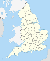
| 26. okt. 2010, 20:34 |  | 817 × 990 (1,33 MB) | Nilfanion (diskussion | bidrag) | {{Information |Description=Map showing the w:ceremonial counties of England including the City of London, in 2010. Equirectangular map projection on WGS 84 datum, with N/S stretched 170% Geographic limits: *West: 6.75W *East: 2.0E *North: 56.0N *Sou |
Du kan ikke overskrive denne fil.
Filanvendelse
De følgende 58 sider bruger denne fil:
- User:Nilfanion/Maps
- User:Nilfanion/Maps/National
- File:East Midlands counties 00.png
- File:East Midlands counties 2009 map.svg
- File:East of England counties 2009 map.svg
- File:English Football Conference county coverage.png
- File:English administrative counties 1889 (numbered).svg
- File:English administrative counties 1965 (numbered).svg
- File:English ceremonial counties 1997.svg
- File:English ceremonial counties 1998.svg
- File:English ceremonial counties 1998 (named).svg
- File:English ceremonial counties 1998 (numbered).svg
- File:English counties 1851.svg
- File:English counties 1851 (named).svg
- File:English counties 1851 (numbered).svg
- File:English counties 1851 with ridings.svg
- File:English county tops map.svg
- File:English geographical counties 1889.svg
- File:English geographical counties 1889 (named).svg
- File:English geographical counties 1889 with ridings.svg
- File:English geographical counties 1889 with ridings (numbered).svg
- File:English geographical counties 1965.svg
- File:English geographical counties 1965 (named).svg
- File:English geographical counties 1965 with ridings.svg
- File:English non-metropolitan districts 2009.svg
- File:English non-metropolitan districts 2019.jpg
- File:Miss Grand UK 2021 - England's participated counties.svg
- File:NUTS 3 regions of North East England map.svg
- File:NUTS 3 regions of North West England 2010 map.svg
- File:NUTS 3 regions of North West England 2015 map.svg
- File:NUTS 3 regions of North West England map.svg
- File:NUTS 3 regions of South East England 2015 map.svg
- File:NUTS 3 regions of South East England map.svg
- File:NUTS 3 regions of South West England map.svg
- File:NUTS 3 regions of Yorkshire and the Humber 2010 map.svg
- File:NUTS 3 regions of Yorkshire and the Humber map.svg
- File:NUTS 3 regions of the East Midlands 2010 map.svg
- File:NUTS 3 regions of the East Midlands map.svg
- File:NUTS 3 regions of the East of England 2010 map.svg
- File:NUTS 3 regions of the East of England 2015 map.svg
- File:NUTS 3 regions of the East of England map.svg
- File:NUTS 3 regions of the West Midlands 2010 map.svg
- File:NUTS 3 regions of the West Midlands map.svg
- File:North East England counties 2.2.png
- File:North East England counties 2009 map.svg
- File:North West England counties.png
- File:North West England counties 2009 map.svg
- File:Northumberland and County Durham location map.svg
- File:SouthWest-local-government-2019.jpg
- File:South East England counties.png
- File:South East England counties 2009 map.svg
- File:South West England counties.png
- File:South West England counties 2009 map.svg
- File:West Midlands counties.png
- File:West Midlands counties 2009 map.svg
- File:Yorkshire & The Humber counties.png
- File:Yorkshire UK 1851 locator map.svg
- File:Yorkshire and the Humber counties 2009 map.svg
Global filanvendelse
Følgende andre wikier anvender denne fil:
- Anvendelser på en.wikipedia.org
- Anvendelser på ja.wikibooks.org