File:English ceremonial counties 2010.svg
跳至導覽
跳至搜尋

此 SVG 檔案的 PNG 預覽的大小:494 × 600 像素。 其他解析度:198 × 240 像素 | 395 × 480 像素 | 633 × 768 像素 | 843 × 1,024 像素 | 1,687 × 2,048 像素 | 1,108 × 1,345 像素。
原始檔案 (SVG 檔案,表面大小:1,108 × 1,345 像素,檔案大小:302 KB)
說明
說明
添加單行說明來描述出檔案所代表的內容
摘要
[編輯]
.svg)
.svg)
.svg)
.svg)
.svg)
.svg)
.svg)
.svg)
.svg)
.svg)
授權條款
[編輯]
我,本作品的著作權持有者,決定用以下授權條款發佈本作品:
此檔案採用共享創意 姓名標示-相同方式分享 3.0 未在地化版本授權條款。
- 您可以自由:
- 分享 – 複製、發佈和傳播本作品
- 重新修改 – 創作演繹作品
- 惟需遵照下列條件:
- 姓名標示 – 您必須指名出正確的製作者,和提供授權條款的連結,以及表示是否有對內容上做出變更。您可以用任何合理的方式來行動,但不得以任何方式表明授權條款是對您許可或是由您所使用。
- 相同方式分享 – 如果您利用本素材進行再混合、轉換或創作,您必須基於如同原先的相同或兼容的條款,來分布您的貢獻成品。

|
已授權您依據自由軟體基金會發行的無固定段落、封面文字和封底文字GNU自由文件授權條款1.2版或任意後續版本,對本檔進行複製、傳播和/或修改。該協議的副本列在GNU自由文件授權條款中。 |
您可以選擇您需要的授權條款。
檔案歷史
點選日期/時間以檢視該時間的檔案版本。
| 日期/時間 | 縮圖 | 尺寸 | 用戶 | 備註 | |
|---|---|---|---|---|---|
| 目前 | 2010年11月23日 (二) 16:39 | | 1,108 × 1,345(302 KB) | Nilfanion(對話 | 貢獻) | thicker lines |
| 2010年11月23日 (二) 16:20 |  | 1,108 × 1,345(294 KB) | Nilfanion(對話 | 貢獻) | tweaks | |
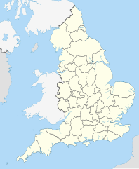
| 2010年10月26日 (二) 20:34 |  | 817 × 990(1.33 MB) | Nilfanion(對話 | 貢獻) | {{Information |Description=Map showing the w:ceremonial counties of England including the City of London, in 2010. Equirectangular map projection on WGS 84 datum, with N/S stretched 170% Geographic limits: *West: 6.75W *East: 2.0E *North: 56.0N *Sou |
無法覆蓋此檔案。
檔案用途
下列58個頁面有用到此檔案:
- User:Nilfanion/Maps
- User:Nilfanion/Maps/National
- File:East Midlands counties 00.png
- File:East Midlands counties 2009 map.svg
- File:East of England counties 2009 map.svg
- File:English Football Conference county coverage.png
- File:English administrative counties 1889 (numbered).svg
- File:English administrative counties 1965 (numbered).svg
- File:English ceremonial counties 1997.svg
- File:English ceremonial counties 1998.svg
- File:English ceremonial counties 1998 (named).svg
- File:English ceremonial counties 1998 (numbered).svg
- File:English counties 1851.svg
- File:English counties 1851 (named).svg
- File:English counties 1851 (numbered).svg
- File:English counties 1851 with ridings.svg
- File:English county tops map.svg
- File:English geographical counties 1889.svg
- File:English geographical counties 1889 (named).svg
- File:English geographical counties 1889 with ridings.svg
- File:English geographical counties 1889 with ridings (numbered).svg
- File:English geographical counties 1965.svg
- File:English geographical counties 1965 (named).svg
- File:English geographical counties 1965 with ridings.svg
- File:English non-metropolitan districts 2009.svg
- File:English non-metropolitan districts 2019.jpg
- File:Miss Grand UK 2021 - England's participated counties.svg
- File:NUTS 3 regions of North East England map.svg
- File:NUTS 3 regions of North West England 2010 map.svg
- File:NUTS 3 regions of North West England 2015 map.svg
- File:NUTS 3 regions of North West England map.svg
- File:NUTS 3 regions of South East England 2015 map.svg
- File:NUTS 3 regions of South East England map.svg
- File:NUTS 3 regions of South West England map.svg
- File:NUTS 3 regions of Yorkshire and the Humber 2010 map.svg
- File:NUTS 3 regions of Yorkshire and the Humber map.svg
- File:NUTS 3 regions of the East Midlands 2010 map.svg
- File:NUTS 3 regions of the East Midlands map.svg
- File:NUTS 3 regions of the East of England 2010 map.svg
- File:NUTS 3 regions of the East of England 2015 map.svg
- File:NUTS 3 regions of the East of England map.svg
- File:NUTS 3 regions of the West Midlands 2010 map.svg
- File:NUTS 3 regions of the West Midlands map.svg
- File:North East England counties 2.2.png
- File:North East England counties 2009 map.svg
- File:North West England counties.png
- File:North West England counties 2009 map.svg
- File:Northumberland and County Durham location map.svg
- File:SouthWest-local-government-2019.jpg
- File:South East England counties.png
- File:South East England counties 2009 map.svg
- File:South West England counties.png
- File:South West England counties 2009 map.svg
- File:West Midlands counties.png
- File:West Midlands counties 2009 map.svg
- File:Yorkshire & The Humber counties.png
- File:Yorkshire UK 1851 locator map.svg
- File:Yorkshire and the Humber counties 2009 map.svg
全域檔案使用狀況
以下其他 wiki 使用了這個檔案:
- en.wikipedia.org 的使用狀況
- ja.wikibooks.org 的使用狀況