File:Environs of Athens-ru.svg
Jump to navigation
Jump to search

Size of this PNG preview of this SVG file: 546 × 600 pixels. Other resolutions: 218 × 240 pixels | 437 × 480 pixels | 699 × 768 pixels | 932 × 1,024 pixels | 1,864 × 2,048 pixels | 910 × 1,000 pixels.
Original file (SVG file, nominally 910 × 1,000 pixels, file size: 553 KB)
Captions
Captions
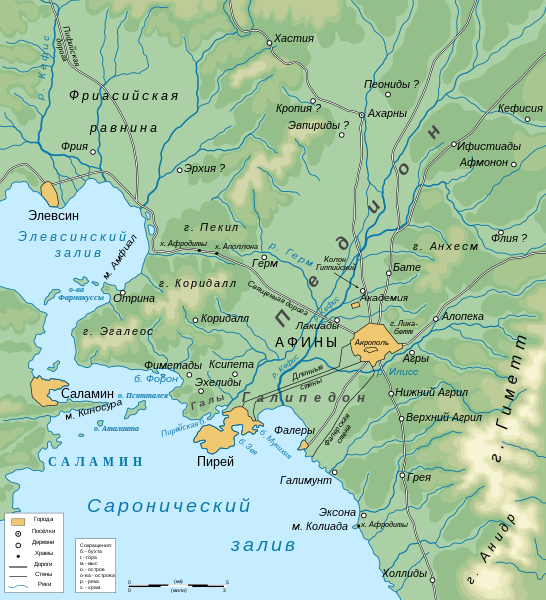
map of environs of Athens
Summary[edit]
| Description |
Русский: Карта, показывающая окрестности античных Афин |
| Date | |
| Source | File:Professor G. Droysens Allgemeiner historischer Handatlas 1886 (134037750).jpg |
| Author | Пётр Тарасьев |
| SVG development | This vector image was created with Inkscape. This file uses embedded text that can be easily translated using a text editor. |
.jpg)

|
This SVG file contains embedded text that can be translated into your language, using any capable SVG editor, text editor or the SVG Translate tool. For more information see: About translating SVG files. |
Licensing[edit]
I, the copyright holder of this work, hereby publish it under the following license:
This file is licensed under the Creative Commons Attribution-Share Alike 4.0 International license.
- You are free:
- to share – to copy, distribute and transmit the work
- to remix – to adapt the work
- Under the following conditions:
- attribution – You must give appropriate credit, provide a link to the license, and indicate if changes were made. You may do so in any reasonable manner, but not in any way that suggests the licensor endorses you or your use.
- share alike – If you remix, transform, or build upon the material, you must distribute your contributions under the same or compatible license as the original.
File history
Click on a date/time to view the file as it appeared at that time.
| Date/Time | Thumbnail | Dimensions | User | Comment | |
|---|---|---|---|---|---|
| current | 10:51, 15 October 2022 | | 910 × 1,000 (553 KB) | Пётр Тарасьев (talk | contribs) | Uploaded own work with UploadWizard |
You cannot overwrite this file.
File usage on Commons
The following page uses this file:
File usage on other wikis
The following other wikis use this file:
- Usage on mk.wikipedia.org
- Usage on ru.wikipedia.org