File:Estrecho de Gibraltar (Seutter).jpg
![File:Estrecho de Gibraltar (Seutter).jpg](https://upload.wikimedia.org/wikipedia/commons/thumb/b/b3/Estrecho_de_Gibraltar_%28Seutter%29.jpg/699px-Estrecho_de_Gibraltar_%28Seutter%29.jpg?20190104231819)
Original file (2,130 × 1,827 pixels, file size: 735 KB, MIME type: image/jpeg)
Captions
Captions
Summary
[edit]DescriptionEstrecho de Gibraltar (Seutter).jpg |
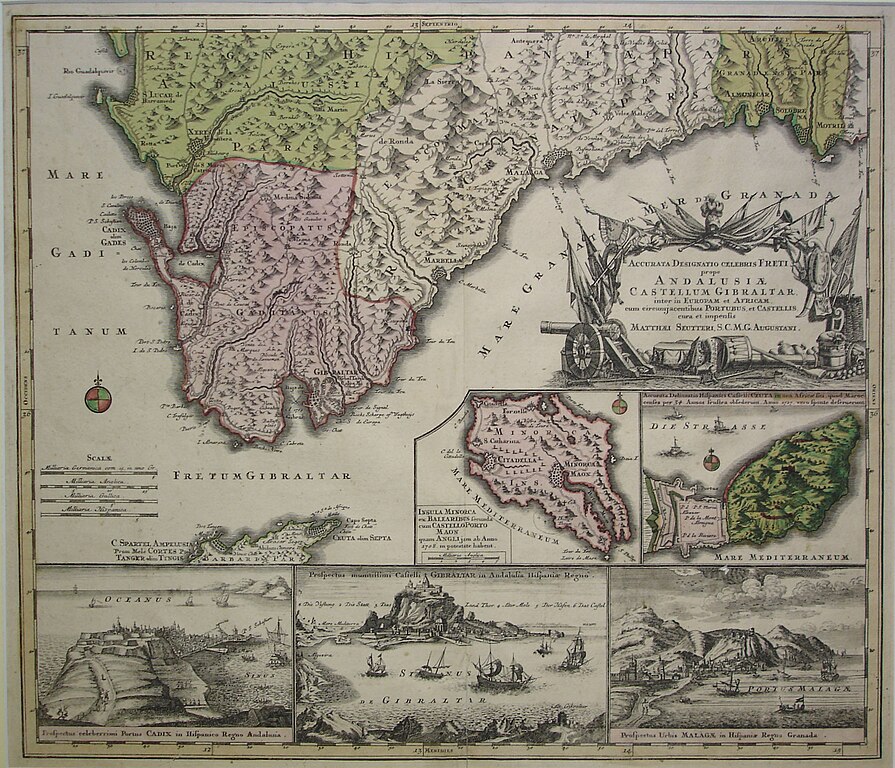
Español: Mapa del estrecho de Gibraltar. Debajo hay mapas de Menorca y Ceuta. En la parte inferior hay vistas de Cádiz, Gibraltar y la Línea de la Concepción y Málaga. Grabado en plancha de cobre coloreado. Tiene el texto: Accurata Designatio Celebris Freti prope Andalusia Castellum Gibratar. |
Date |
circa 1740 date QS:P,+1740-00-00T00:00:00Z/9,P1480,Q5727902 |
Source | [1] |
Author | Mathias Seutter |
Licensing
[edit]Public domainPublic domainfalsefalse |
![]() |
This work is in the public domain in its country of origin and other countries and areas where the copyright term is the author's life plus 70 years or fewer.
|
This file has been identified as being free of known restrictions under copyright law, including all related and neighboring rights. |
https://creativecommons.org/publicdomain/mark/1.0/PDMCreative Commons Public Domain Mark 1.0falsefalse
File history
Click on a date/time to view the file as it appeared at that time.
Date/Time | Thumbnail | Dimensions | User | Comment | |
---|---|---|---|---|---|
current | 23:18, 4 January 2019 | ![]() | 2,130 × 1,827 (735 KB) | CarlosVdeHabsburgo (talk | contribs) | User created page with UploadWizard |
You cannot overwrite this file.
File usage on Commons
The following page uses this file:
Metadata
This file contains additional information such as Exif metadata which may have been added by the digital camera, scanner, or software program used to create or digitize it. If the file has been modified from its original state, some details such as the timestamp may not fully reflect those of the original file. The timestamp is only as accurate as the clock in the camera, and it may be completely wrong.
Camera manufacturer | SONY |
---|---|
Camera model | DSC-P100 |
Exposure time | 1/60 sec (0.016666666666667) |
F-number | f/2.8 |
ISO speed rating | 100 |
Date and time of data generation | 11:33, 13 May 2017 |
Lens focal length | 7.9 mm |
Image title | |
Width | 2,592 px |
Height | 1,944 px |
Bits per component |
|
Pixel composition | RGB |
Orientation | Normal |
Number of components | 3 |
Horizontal resolution | 200 dpi |
Vertical resolution | 200 dpi |
Software used | Adobe Photoshop CS5 Windows |
File change date and time | 12:58, 8 October 2017 |
Y and C positioning | Co-sited |
Exposure Program | Normal program |
Exif version | 2.2 |
Date and time of digitizing | 11:33, 13 May 2017 |
Meaning of each component |
|
Image compression mode | 8 |
APEX shutter speed | 5.906891 |
APEX aperture | 2.970854 |
APEX exposure bias | 0 |
Maximum land aperture | 3 APEX (f/2.83) |
Metering mode | Pattern |
Light source | Unknown |
Flash | Flash fired, strobe return light detected, compulsory flash firing |
Supported Flashpix version | 1 |
Color space | sRGB |
File source | Digital still camera |
Scene type | A directly photographed image |
Custom image processing | Normal process |
Exposure mode | Auto exposure |
White balance | Auto white balance |
Scene capture type | Standard |
Contrast | Normal |
Saturation | Normal |
Sharpness | Normal |
Date metadata was last modified | 14:58, 8 October 2017 |
Unique ID of original document | xmp.did:9D6669AB17ACE711B04CCA265C172CF1 |
Structured data
0.01666666666666666666 second
2.8
7.9 millimetre
100
image/jpeg
- Maps of straits
- Old maps of the Strait of Gibraltar
- Views of Cádiz
- Views of Gibraltar and La Línea de la Concepción
- Views of Málaga
- Old maps of Menorca
- History of Ceuta
- History of Cádiz
- History of Gibraltar
- History of La Línea de la Concepción
- History of Menorca
- Ceuta in the 18th century
- Maps by Matthäus Seutter
- 18th-century maps of Andalusia
- Andalusia in the 1740s