File:Europe, 1787 (Kitchin).jpg
跳至導覽
跳至搜尋

預覽大小:732 × 599 像素。 其他解析度:293 × 240 像素 | 586 × 480 像素 | 938 × 768 像素 | 1,251 × 1,024 像素 | 2,501 × 2,048 像素 | 9,950 × 8,147 像素。
原始檔案 (9,950 × 8,147 像素,檔案大小:17.44 MB,MIME 類型:image/jpeg)
說明
說明
添加單行說明來描述出檔案所代表的內容
摘要
[編輯].jpg&action=edit§ion=1)
| 警告 | 部分瀏覽器在瀏覽此圖片的完整大小時可能會遇到困難:該圖片中有數量巨大的像素點,可能無法完全載入或者導致您的瀏覽器停止回應。 |
|---|
.jpg&flash=no)
| 描述 |
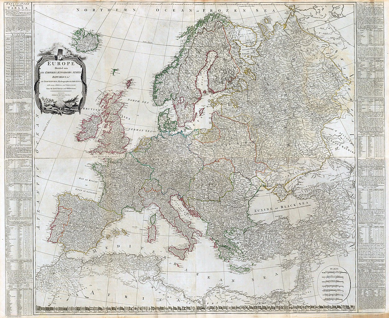
English: (Composite of) Europe divided into its empires, kingdoms, states, republics, &c. By Thos. Kitchin, Hydrographer to the King, with many additions and improvements from the latest surveys and observations. London, published by Robt. Sayer, Fleet Street, as the Act directs, Jany. 1st, 1787.
Engraved map on 4 sheets. Sheets have titles: Western part of the northern states including the British Islands, Norway, Denmark and part of Sweden -- Eastern part of the northern states, including the eastern part of Sweden; European Russia, &c. -- Western part of the Mediterranean Sea with the coasts of Spain, France, Italy, Barbary -- Eastern part of the Mediterranean Sea with the coasts of Turky [sic], Anatolia, Syria, Egypt and Barbary. Country boundaries in outline color. Relief shown pictorially. Includes worldwide flags at bottom, and text and tables on sides. David Rumsey Collection copy mounted as 2 sheets. Prime meridians: Ferro and London. (W 25--E 48/N 75--N 29) |
||||
| 日期 | (publication date: 1790). | ||||
| 來源 | David Rumsey Map Collection. | ||||
| 作者 | Kitchin, Thomas (1718-1784) | ||||
| 授權許可 (重用此檔案) |
|
||||
授權條款
[編輯].jpg&action=edit§ion=2)
此檔案採用共享創意 姓名標示-相同方式分享 4.0 國際授權條款。
- 您可以自由:
- 分享 – 複製、發佈和傳播本作品
- 重新修改 – 創作演繹作品
- 惟需遵照下列條件:
- 姓名標示 – 您必須指名出正確的製作者,和提供授權條款的連結,以及表示是否有對內容上做出變更。您可以用任何合理的方式來行動,但不得以任何方式表明授權條款是對您許可或是由您所使用。
- 相同方式分享 – 如果您利用本素材進行再混合、轉換或創作,您必須基於如同原先的相同或兼容的條款,來分布您的貢獻成品。
檔案歷史
點選日期/時間以檢視該時間的檔案版本。
| 日期/時間 | 縮圖 | 尺寸 | 用戶 | 備註 | |
|---|---|---|---|---|---|
| 目前 | 2018年11月29日 (四) 18:37 | | 9,950 × 8,147(17.44 MB) | FDRMRZUSA(對話 | 貢獻) | User created page with UploadWizard |
無法覆蓋此檔案。
檔案用途
下列頁面有用到此檔案:
全域檔案使用狀況
以下其他 wiki 使用了這個檔案:
- en.wikipedia.org 的使用狀況
.jpg&oldid=718876431)