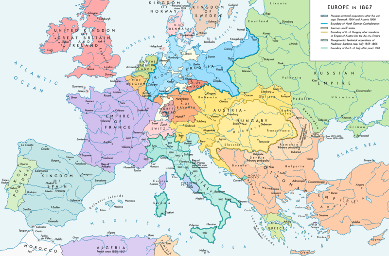
File:Europe 1867 map en.png
Wikimedia Commonsista
Siirry navigaatioon
Siirry hakuun

Tämän esikatselun koko: 800 × 526 kuvapistettä. Muut resoluutiot: 320 × 211 kuvapistettä | 640 × 421 kuvapistettä | 1 024 × 674 kuvapistettä | 1 280 × 842 kuvapistettä | 2 284 × 1 503 kuvapistettä.
Alkuperäinen tiedosto (2 284 × 1 503 kuvapistettä, 1,07 MiB, MIME-tyyppi: image/png)
Tiedoston tiedot
Rakenteinen tieto
Kuvatekstit
Kuvatekstit
Lisää yhden rivin pituinen kuvaus tästä tiedostosta
Yhteenveto
[muokkaa]| KuvausEurope 1867 map en.png |
English: Europe 1867. Historical map of the political situation after the forming of the North German Confederation, the Italian Risorgimento (with the exception of the Roman part of the Papal States) and the Austro-Hungarian Compromise of 1867. Please don't alter the map, when you think there something not written or depicted correctly. Leave a message at the talk page of the file. After a verificiation and a possible discussion, i will upload a new map version with all new changes. This prevents an unnecessary waste of disc space and ensures a good result, aesthetically and contentwise. - The author. Deutsch: Europa 1867. Historische Karte der politischen Situation in Europa nach der Gründung des Norddeutschen Bundes, des italienischen Risorgimento (mit Ausnahme des röm. Teils des Kirchenstaats) und dem Österreichisch-Ungarischen Ausgleich von 1867. Bitte die Karte bei Änderungs- und Korrekturwünschen nicht selbst verändern, sondern eine Anmerkung im Diskussionsbereich der Bilddatei hinterlassen. Nach einer Prüfung und ggfs. Diskussion werden evtl. Änderungen von mir zusammengefasst eingearbeitet. Das vermeidet unnötige Speicherplatz-Verschwendung und gewährleistet ein ästhetisch ansprechendes und inhaltlich korrektes Ergebnis. - Der Urheber. |
| Päiväys | |
| Lähde |
Oma teos. Source of Information: Historical atlases and maps – Ramsay Muir, George Philip (ed.): Philip's New School Atlas of Universal History, George Philip & Son, Ltd., London 1928 – Dr. Walter Leisering (ed.): Putzger Historischer Weltatlas, Cornelsen Verlag, Berlin 1992, ISBN 3-464-00176-8 – Bayerischer Schulbuch-Verlag (ed.): Großer Historischer Weltatlas, Dritter Teil, Neuzeit, Bayerischer Schulbuch-Verlag, München 1981, ISBN 3-7627-6021-7. – Prof. Dr. Vadim Oswalt u. Prof. Dr. Hans Ulrich Rudolf (ed.): Klett-Perthes Atlas zur Weltgeschichte, Ernst Klett Verlag, Stuttgart 2011, ISBN 978-3-12-828194-0 – Ziegelbrenner: Karte des Norddeutschen Bundes 1866–1871, 6 June 2014 version (map link) Other publications – Francesco Traniello u. Gianni Sofri: Der lange Weg zur Nation. Das italienische Risorgimento, Verlag W. Kohlhammer, Stuttgart 2012, ISBN 978-3-17-021898-7 |
| Tekijä | Alexander Altenhof |
| Muut versiot |
|
Recompressed without quality loss with OptiPNG (1.35 MB > 1.06 MB)
Lisenssi
[muokkaa]Minä, tämän teoksen tekijänoikeuksien haltija, julkaisen täten tämän teoksen seuraavalla lisenssillä:
Tämä tiedosto on lisensoitu Creative Commons Nimeä-JaaSamoin 4.0 Kansainvälinen -lisenssillä.
- Voit:
- jakaa – kopioida, levittää ja esittää teosta
- remiksata – valmistaa muutettuja teoksia
- Seuraavilla ehdoilla:
- nimeäminen – Sinun on mainittava lähde asianmukaisesti, tarjottava linkki lisenssiin sekä merkittävä, mikäli olet tehnyt muutoksia. Voit tehdä yllä olevan millä tahansa kohtuullisella tavalla, mutta et siten, että annat ymmärtää lisenssinantajan suosittelevan sinua tai teoksen käyttöäsi.
- jaa samoin – Jos muutat tai perustat tähän työhön, voit jakaa tuloksena syntyvää työtä vain tällä tai tämän kaltaisella lisenssillä.
Tiedoston historia
Päiväystä napsauttamalla näet, millainen tiedosto oli kyseisellä hetkellä.
| Päiväys | Pienoiskuva | Koko | Käyttäjä | Kommentti | |
|---|---|---|---|---|---|
| nykyinen | 14. huhtikuuta 2017 kello 23.42 |  | 2 284 × 1 503 (1,07 MiB) | KaterBegemot (keskustelu | muokkaukset) | Empire of France (not Kingdom), changed main caption to "Europe in 1867", fixed font size of "Piedmont-Sardinia", minor changes |
| 4. syyskuuta 2016 kello 21.36 |  | 2 284 × 1 503 (1,06 MiB) | KaterBegemot (keskustelu | muokkaukset) | {{Information |Description ={{en|1=Europe 1867. Historical map of the political situation after the forming of the North German Confederation, the Italian Risorgimento (with the exception of the Roman part of the Papal States) and the Austro-Hungari... |
Et voi tallentaa uutta tiedostoa tämän tilalle.
Tiedoston käyttö
Seuraavat 4 sivua käyttävät tätä tiedostoa:
Tiedoston järjestelmänlaajuinen käyttö
Seuraavat muut wikit käyttävät tätä tiedostoa:
- Käyttö sivustolla ast.wikipedia.org
- Käyttö sivustolla en.wikipedia.org
- Käyttö sivustolla et.wikipedia.org
- Käyttö sivustolla it.wikipedia.org
Metatieto
Tämä tiedosto sisältää esimerkiksi kuvanlukijan, digikameran tai kuvankäsittelyohjelman lisäämiä lisätietoja. Kaikki tiedot eivät enää välttämättä vastaa todellisuutta, jos kuvaa on muokattu sen alkuperäisen luonnin jälkeen.
| Kuvan resoluutio leveyssuunnassa | 70 dpi |
|---|---|
| Kuvan resoluutio korkeussuunnassa | 70 dpi |
| Väriavaruus | Kalibroimaton |
| Kuvan leveys | 2 284 px |
| Kuvan korkeus | 1 503 px |
| Käytetty ohjelmisto | Adobe Photoshop CC 2017 (Windows) |
| Digitointipäivämäärä | 15. huhtikuuta 2017 kello 03.05 |
| Viimeksi muokattu | 15. huhtikuuta 2017 kello 03.22 |
| Metatietojen viimeinen muokkauspäivämäärä | 15. huhtikuuta 2017 kello 03.22 |
| Alkuperäisen asiakirjan tunniste | xmp.did:fd41fa5f-5199-fd40-bec6-d1a7668cc651 |
