File:Europe laea location map.svg
Spring til navigation
Spring til søgning

Size of this PNG preview of this SVG file: 701 × 599 pixels. Andre opløsninger: 281 × 240 pixels | 561 × 480 pixels | 898 × 768 pixels | 1.198 × 1.024 pixels | 2.395 × 2.048 pixels | 1.401 × 1.198 pixels.
Oprindelig fil (SVG fil, basisstørrelse 1.401 × 1.198 pixels, filstørrelse: 2,21 MB)
Captions
Captions
Tilføj en kort forklaring på en enkelt linje om hvad filen viser
Beskrivelse
[redigér]| Beskrivelse |
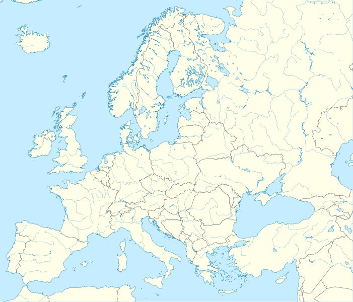
Deutsch: Positionskarte Europa; Politisch mit Staatsgrenzen, Inlandgewässer; Flächentreue Azimutalprojektion
English: Location map Europe; Political with state boundaries, inland water; Lambert azimuthal equal-area projection
Français : Carte de localisation Europe; Politique avec frontières d'Etats, mers intérieures; projection de Lambert azimuthale
Русский: Политическая карта Европы с границами государств и внутренними водами по состоянию на 2010 год (равновеликая азимутальная проекция Ламберта)
|
||
| Dato | |||
| Kilde |
Eget arbejde
|
||
| Forfatter | Alexrk2 | ||
| Andre versioner |
Derivative works of this file:
[]
|
||
| SVG udvikling | Vektorgrafikken blev lavet med Inkscape.
, or with something else.
|


.svg)


Licensering
[redigér]
Jeg, dette værks ophavsretsindehaver, publicerer hermed værket under den følgende licens:
Denne fil er udgivet under Creative Commons Kreditering-Del på samme vilkår 3.0 Ikke-porteret-licensen.
- Du må frit:
- at dele – at kopiere, distribuere og overføre værket
- at remixe – at tilpasse værket
- Under følgende vilkår:
- kreditering – Du skal give passende kreditering, angive et link til licensen, og oplyse om der er foretaget ændringer. Du må gøre det på enhver fornuftig måde, men ikke på en måde der antyder at licensgiveren godkender dig eller din anvendelse.
- deling på samme vilkår – Hvis du bearbejder, ændrer eller bygger videre på dette værk, skal du distribuere dine bidrag under den samme eller en kompatibel licens som originalen.
Filhistorik
Klik på en dato/tid for at se filen som den så ud på det tidspunkt.
| Dato/tid | Miniaturebillede | Dimensioner | Bruger | Kommentar | |
|---|---|---|---|---|---|
| nuværende | 20. aug. 2012, 22:57 | | 1.401 × 1.198 (2,21 MB) | McZusatz (diskussion | bidrag) | Reverted to version as of 19:40, 10 March 2010 (...thumb fixed?) |
| 20. aug. 2012, 22:56 |  | 1.401 × 1.198 (1,45 MB) | McZusatz (diskussion | bidrag) | Reverted to version as of 18:44, 10 March 2010 (fixing thumb...) | |
| 10. mar. 2010, 19:40 |  | 1.401 × 1.198 (2,21 MB) | Alexrk2 (diskussion | bidrag) | +San Marino, enh. coastline & countries | |
| 10. mar. 2010, 18:44 |  | 1.401 × 1.198 (1,45 MB) | Alexrk2 (diskussion | bidrag) | == Summary == {{Information |Description= {{de|Positionskarte Europa; Politisch mit Staatsgrenzen, Inlandgewässer; Flächentreue Azimutalprojektion}} {{en|Location map Europe; Political with state boundaries, inland water; L |
Du kan ikke overskrive denne fil.
Filanvendelse
Flere end 100 sider henviser til denne fil. Den følgende liste viser kun de 100 første henvisninger. En komplet liste er tilgængelig.
- File:Abkhazia in Europe (de-facto).svg
- File:Abkhazia in Europe (de-facto) (-rivers -mini map).svg
- File:Akrotiri and Dhekelia in Europe.svg
- File:Akrotiri and Dhekelia in Europe (-rivers -mini map).svg
- File:Aland in Europe.svg
- File:Aland in Europe (-rivers -mini map).svg
- File:Albania in Europe.svg
- File:Albania in Europe (-rivers -mini map).svg
- File:Andorra in Europe.svg
- File:Andorra in Europe (-rivers -mini map).svg
- File:Armenia in Europe.svg
- File:Armenia in Europe (-rivers -mini map).svg
- File:Artsakh in Europe.svg
- File:Austria in Europe.svg
- File:Austria in Europe (-rivers -mini map).svg
- File:Austria in European Union.svg
- File:Azerbaijan in Europe.svg
- File:Azerbaijan in Europe (-rivers -mini map).svg
- File:Belarus in Europe.svg
- File:Belarus in Europe (-rivers -mini map).svg
- File:Belgium in Europe.svg
- File:Belgium in Europe (-rivers -mini map).svg
- File:Bosnia and Herzegovina in Europe.svg
- File:Bosnia and Herzegovina in Europe (-rivers -mini map).svg
- File:Bulgaria in Europe.svg
- File:Bulgaria in Europe (-rivers -mini map).svg
- File:Croatia in Europe.svg
- File:Croatia in Europe (-rivers -mini map).svg
- File:Cyprus in Europe.svg
- File:Cyprus in Europe (-rivers -mini map).svg
- File:Cyprus in Europe (de-facto).svg
- File:Cyprus in Europe (de-facto) (-rivers -mini map).svg
- File:Czech Republic in Europe.svg
- File:Czech Republic in Europe (-rivers -mini map).svg
- File:Denmark in Europe.svg
- File:Denmark in Europe (-rivers -mini map).svg
- File:Estonia in Europe.svg
- File:Estonia in Europe (-rivers -mini map).svg
- File:Europe EU laea location map.svg
- File:Europe blank laea location map.svg
- File:Europe bluemarble laea location map.jpg
- File:Europe laea location map.svg
- File:Europe laea location map with borders.svg (filomdirigering)
- File:Europe natural laea location map.jpg
- File:Europe relief laea location map.jpg
- File:Europe relief laea location map BG.png
- File:Faroe Islands in Europe.svg
- File:Faroe Islands in Europe (-rivers -mini map).svg
- File:Finland in Europe.svg
- File:Finland in Europe (-rivers -mini map).svg
- File:France in Europe.svg
- File:France in Europe (-rivers -mini map).svg
- File:France in Europe (relief).svg
- File:Georgia in Europe.svg
- File:Georgia in Europe (de-facto).svg
- File:Germany in Europe.svg
- File:Gibraltar in Europe.svg
- File:Greece in Europe.svg
- File:Guernsey in Europe.svg
- File:Hungary in Europe.svg
- File:Iceland in Europe.svg
- File:Ireland in Europe.svg
- File:Isle of Man in Europe.svg
- File:Italy in Europe.svg
- File:Jersey in Europe.svg
- File:Kazakhstan in Europe.svg
- File:Kingdom of Denmark in Europe.svg
- File:Kosovo in Europe (de-facto).svg
- File:Latvia in Europe.svg
- File:Liechtenstein in Europe.svg
- File:Lithuania in Europe.svg
- File:Luxembourg in Europe.svg
- File:Luxembourg in Europe (special marker).svg
- File:Macedonia in Europe.svg
- File:Malta in Europe.svg
- File:Moldova in Europe.svg
- File:Monaco in Europe.svg
- File:Montenegro in Europe.svg
- File:Netherlands in Europe.svg
- File:Northern Cyprus in Europe (de-facto).svg
- File:Norway in Europe.svg
- File:Poland in Europe.svg
- File:Portugal in Europe.svg
- File:Romania in Europe.svg
- File:Russia in Europe.svg
- File:San Marino in Europe.svg
- File:Serbia in Europe.svg
- File:Serbia in Europe (de-facto).svg
- File:Slovakia in Europe.svg
- File:Slovenia in Europe.svg
- File:South Ossetia in Europe (de-facto).svg
- File:Spain in Europe.svg
- File:Sweden in Europe.svg
- File:Switzerland in Europe.svg
- File:Transnistria in Europe.svg
- File:Transnistria in Europe (special marker).svg
- File:Turkey in Europe.svg
- File:Ukraine in Europe.svg
- File:United Kingdom in Europe.svg
- File:United Kingdom in Europe (wo crown dependencies).svg
.svg)
_(-rivers_-mini_map).svg)
.svg)
.svg)
.svg)
.svg)
.svg)
.svg)
.svg)
.svg)
.svg)
.svg)
.svg)
.svg)
.svg)
.svg)
_(-rivers_-mini_map).svg)
.svg)
.svg)
.svg)
.svg)
.svg)
.svg)
.svg)
.svg)
.svg)
.svg)
.svg)
.svg)
.svg)
.svg)
.svg)
Se flere henvisninger til denne fil.
Global filanvendelse
Følgende andre wikier anvender denne fil:
- Anvendelser på als.wikipedia.org
- Anvendelser på an.wikipedia.org
- Anvendelser på av.wikipedia.org
- Anvendelser på az.wikipedia.org
- Dunay
- Reyn
- UEFA Çempionlar Liqası 1994/1995
- UEFA Çempionlar Liqası 2007/2008
- Şablon:Yer xəritəsi Avropa
- Aqriate
- Akkona (səhra)
- Bardenas-Reales
- Pişinas
- Tabernas (səhra)
- Aleşkov qumları
- Mançester Arenada terror (2017)
- Avropa Gənclər Olimpiya Festivalı
- UEFA Çempionlar Liqası 2017/2018
- Yan çayı
- UEFA Çempionlar Liqası 2018/2019
- Moneqros səhrası
- UEFA Çempionlar Liqası 2019/2020
- UEFA Çempionlar Liqası 2020/2021
- UEFA Çempionlar Liqası 2021/2022
- Anvendelser på ba.wikipedia.org
Vis flere globale anvendelser af denne fil.