File:Ewiniar 2006-07-10 0619Z RKSG radar.png
跳转到导航
跳转到搜索
没有更高的分辨率。
Ewiniar_2006-07-10_0619Z_RKSG_radar.png (537 × 460像素,文件大小:648 KB,MIME类型:image/png)
说明
说明
添加一行文字以描述该文件所表现的内容
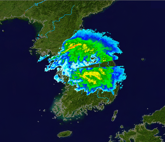
| 描述 | Radar data from U.S. Air Force WSR-88Ds in South Korea at Camp Humphreys Airbase (RKSG), from 2006-07-10 when Severe Tropical Storm Ewiniar made landfall, overlaid on NASA Blue Marble base map. | ||||||||
| 日期 | / created 2006-11-13 | ||||||||
| 来源 | RKSG data can be obtained here. | ||||||||
| 作者 | Rada data: NOAA/U.S. Air Force, Blue Marble map: NASA | ||||||||
| 授权 (二次使用本文件) |
|


文件历史
点击某个日期/时间查看对应时刻的文件。
| 日期/时间 | 缩略图 | 大小 | 用户 | 备注 | |
|---|---|---|---|---|---|
| 当前 | 2006年11月13日 (一) 05:09 | | 537 × 460(648 KB) | NSLE-Chacor(留言 | 贡献) | slightly cropped |
| 2006年11月13日 (一) 05:01 |  | 687 × 460(796 KB) | NSLE-Chacor(留言 | 贡献) | {{Information |Description=Radar data from U.S. Air Force WSR-88Ds in South Korea at Camp Humphreys Airbase (RKSG), from 2006-07-10 when Severe Tropical Storm Ewiniar made landfall, overlaid on NASA Blue Marble base map.|Source=RKSG data can be obtain |
您不可以覆盖此文件。
文件用途
以下页面使用本文件:
全域文件用途
以下其他wiki使用此文件:
- en.wikipedia.org上的用途
- pt.wikipedia.org上的用途
- zh.wikipedia.org上的用途