File:Exploded Typical Joint Assemblies - Bunker Hill Bridge, Spanning Lyle Creek, bypassed section of Island Ford Road, Claremont, Catawba County, NC HAER NC-46 (sheet 6 of 6).png
Jump to navigation
Jump to search

Size of this preview: 800 × 526 pixels. Other resolutions: 320 × 210 pixels | 640 × 421 pixels | 1,024 × 673 pixels | 1,280 × 842 pixels | 2,560 × 1,684 pixels | 14,333 × 9,427 pixels.
Original file (14,333 × 9,427 pixels, file size: 3.61 MB, MIME type: image/png)
Captions
Captions
Add a one-line explanation of what this file represents
| This image is a JPEG version of the original TIF image at File: Exploded Typical Joint Assemblies - Bunker Hill Bridge, Spanning Lyle Creek, bypassed section of Island Ford Road, Claremont, Catawba County, NC HAER NC-46 (sheet 6 of 6).tif.
However, any edits to the image should be based on the original TIF version in order to prevent generation loss, and both versions should be updated. Do not make edits based on this version. |
Summary
[edit]| Warning | The original file is very high-resolution. It might not load properly or could cause your browser to freeze when opened at full size. |
|---|
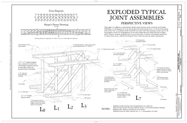
| Exploded Typical Joint Assemblies - Bunker Hill Bridge, Spanning Lyle Creek, bypassed section of Island Ford Road, Claremont, Catawba County, NC | ||||
|---|---|---|---|---|
| Photographer |
Anderson, Richard K. Jr. |
|||
| Title |
Exploded Typical Joint Assemblies - Bunker Hill Bridge, Spanning Lyle Creek, bypassed section of Island Ford Road, Claremont, Catawba County, NC |
|||
| Depicted place | North Carolina; Catawba County; Claremont | |||
| Date | 2004 | |||
| Current location |
Library of Congress Prints and Photographs Division Washington, D.C. 20540 USA http://hdl.loc.gov/loc.pnp/pp.print |
|||
| Accession number |
HAER NC-46 (sheet 6 of 6) |
|||
| Credit line |
|
|||
| Notes |
|
|||
| References |
Related names:
|
|||
| Source | https://www.loc.gov/pictures/item/nc0503.sheet.00006a | |||
| Permission (Reusing this file) |
|
|||
| Other versions |
.png) .png) .png) .png) |
|||

.png&action=edit§ion=1)
.png&flash=no)
| Object location | | View this and other nearby images on: OpenStreetMap |
|---|
.png¶ms=035.714440_N_-081.146390_E_globe:Earth_class:object_type:object__&language=en)
File history
Click on a date/time to view the file as it appeared at that time.
| Date/Time | Thumbnail | Dimensions | User | Comment | |
|---|---|---|---|---|---|
| current | 09:58, 21 August 2014 | | 14,333 × 9,427 (3.61 MB) | Fæ (talk | contribs) | {{Compressed version|file=File:Exploded_Typical_Joint_Assemblies_-_Bunker_Hill_Bridge,_Spanning_Lyle_Creek,_bypassed_section_of_Island_Ford_Road,_Claremont,_Catawba_County,_NC_HAER_NC-46_(sheet_6_of_6).tif|thumb=nothumb}} =={{int:filedesc}}== {{Photog... |
You cannot overwrite this file.
File usage on Commons
The following 9 pages use this file:
- File:Bunker Hill Bridge, Title Sheet - Bunker Hill Bridge, Spanning Lyle Creek, bypassed section of Island Ford Road, Claremont, Catawba County, NC HAER NC-46 (sheet 1 of 6).png
- File:Bunker Hill Bridge, Title Sheet - Bunker Hill Bridge, Spanning Lyle Creek, bypassed section of Island Ford Road, Claremont, Catawba County, NC HAER NC-46 (sheet 1 of 6).tif
- File:Cutaway Perspective - Bunker Hill Bridge, Spanning Lyle Creek, bypassed section of Island Ford Road, Claremont, Catawba County, NC HAER NC-46 (sheet 5 of 6).png
- File:Cutaway Perspective - Bunker Hill Bridge, Spanning Lyle Creek, bypassed section of Island Ford Road, Claremont, Catawba County, NC HAER NC-46 (sheet 5 of 6).tif
- File:East Portal Elevation; Cross Section at Center - Bunker Hill Bridge, Spanning Lyle Creek, bypassed section of Island Ford Road, Claremont, Catawba County, NC HAER NC-46 (sheet 4 of 6).png
- File:East Portal Elevation; Cross Section at Center - Bunker Hill Bridge, Spanning Lyle Creek, bypassed section of Island Ford Road, Claremont, Catawba County, NC HAER NC-46 (sheet 4 of 6).tif
- File:Exploded Typical Joint Assemblies - Bunker Hill Bridge, Spanning Lyle Creek, bypassed section of Island Ford Road, Claremont, Catawba County, NC HAER NC-46 (sheet 6 of 6).png
- File:Exploded Typical Joint Assemblies - Bunker Hill Bridge, Spanning Lyle Creek, bypassed section of Island Ford Road, Claremont, Catawba County, NC HAER NC-46 (sheet 6 of 6).tif
- File:Longitudinal Section; Partial Plans - Bunker Hill Bridge, Spanning Lyle Creek, bypassed section of Island Ford Road, Claremont, Catawba County, NC HAER NC-46 (sheet 3 of 6).tif
.png)
.png&oldid=664344579)