File:Fes el bali Talaa Kbira and Sghira map.png
Jump to navigation
Jump to search
Size of this preview: 800 × 417 pixels. Other resolutions: 320 × 167 pixels | 640 × 333 pixels | 943 × 491 pixels.
Original file (943 × 491 pixels, file size: 122 KB, MIME type: image/png)
Captions
Captions
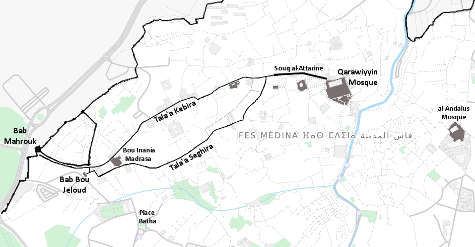
The path of Talaa Kbira and Talaa Sghira in Fes el-Bali.
Summary
[edit]
| Description |
English: A map of Talaa Kbira and Talaa Sghira streets in Fes el-Bali, with a few key buildings and landmarks highlighted.
Base map was taken from OpenStreetMap, and outline of city walls was taken from another map available on Commons (Carte Enceintes de Fes.PNG). I added the labels and highlighted some key buildings. The result is not a work of art, and unfortunately I had to work with a lesser-resolution version, but hopefully it can serve as a placeholder while a better map is created in the future (suggestions for open-source maps welcome). |
| Date | |
| Source | Own work |
| Author | Robert Prazeres |
Licensing
[edit]
I, the copyright holder of this work, hereby publish it under the following license:
This file is licensed under the Creative Commons Attribution-Share Alike 4.0 International license.
- You are free:
- to share – to copy, distribute and transmit the work
- to remix – to adapt the work
- Under the following conditions:
- attribution – You must give appropriate credit, provide a link to the license, and indicate if changes were made. You may do so in any reasonable manner, but not in any way that suggests the licensor endorses you or your use.
- share alike – If you remix, transform, or build upon the material, you must distribute your contributions under the same or compatible license as the original.
File history
Click on a date/time to view the file as it appeared at that time.
| Date/Time | Thumbnail | Dimensions | User | Comment | |
|---|---|---|---|---|---|
| current | 08:01, 30 March 2020 | | 943 × 491 (122 KB) | R Prazeres (talk | contribs) | Uploaded own work with UploadWizard |
You cannot overwrite this file.
File usage on Commons
There are no pages that use this file.
File usage on other wikis
The following other wikis use this file:
- Usage on ar.wikipedia.org
- Usage on en.wikipedia.org
- Usage on fr.wikipedia.org