File:Field of cavalry operations east of Gettysburg, July 2nd & 3rd 1863. LOC 99447495.jpg
Jump to navigation
Jump to search

Size of this preview: 431 × 600 pixels. Other resolutions: 172 × 240 pixels | 345 × 480 pixels | 552 × 768 pixels | 735 × 1,024 pixels | 1,760 × 2,450 pixels.
Original file (1,760 × 2,450 pixels, file size: 700 KB, MIME type: image/jpeg)
Captions
Captions
Add a one-line explanation of what this file represents
Summary[edit]
| Description |
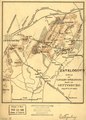
English: Scale ca. 1:56,000. LC Civil War Maps (2nd ed.), 328 Map of the country east of Gettysburg, showing the location of cavalry engagements by crossed swords, positions of the 3rd and 16th Pennsylvania cavalry, roads, houses and names of residents, vegetation, and relief by hachures. Description derived from published bibliography. Available also through the Library of Congress web site as raster image. |
||
| Title | Field of cavalry operations east of Gettysburg, July 2nd & 3rd 1863. | ||
| Shelf ID | G3824.G3S5 1863 .B5 | ||
| Date | |||
| Source | https://www.loc.gov/item/99447495/ | ||
| Author | Bien, Julius | ||
| Permission (Reusing this file) |
|
||
| Other versions |
|
||
| Location | United States · Pennyslvania · Gettysburg | ||
| Part of | Military Battles And Campaigns · American Memory · Civil War Maps · Catalog · Geography And Map Division | ||
| Subject | Pennyslvania · Gettysburg, Battle Of, Gettysburg, Pa. · United States · Maps · Gettysburg (Pa.), Battle Of · Gettysburg |

Licensing[edit]
|
This is a faithful photographic reproduction of a two-dimensional, public domain work of art. The work of art itself is in the public domain for the following reason:
The official position taken by the Wikimedia Foundation is that "faithful reproductions of two-dimensional public domain works of art are public domain".
This photographic reproduction is therefore also considered to be in the public domain in the United States. In other jurisdictions, re-use of this content may be restricted; see Reuse of PD-Art photographs for details. | ||||
File history
Click on a date/time to view the file as it appeared at that time.
| Date/Time | Thumbnail | Dimensions | User | Comment | |
|---|---|---|---|---|---|
| current | 06:45, 27 July 2018 | | 1,760 × 2,450 (700 KB) | Fæ (talk | contribs) | LOC Maps https://www.loc.gov/item/99447495/ #15046 |
You cannot overwrite this file.
File usage on Commons
The following page uses this file: