File:Finland tern roads.png
Jump to navigation
Jump to search
Size of this preview: 341 × 600 pixels. Other resolutions: 136 × 240 pixels | 455 × 800 pixels.
Original file (455 × 800 pixels, file size: 116 KB, MIME type: image/png)
Captions
Captions
Add a one-line explanation of what this file represents
Summary[edit]
| Description |
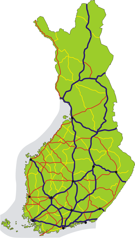
English: Map of the TERN roads in Finland, shown in dark blue. National roads number 1–29 are red, 40–98 are yellow. Black dots show the 12 major urban areas.
Suomi: Kartta Suomen alueella kulkevista TERN-tieverkkoon kuuluvista teistä. TERN-tiet on merkitty karttaan tummansinisellä. Lisäksi karttaan on merkitty TERN-tieverkon ulkopuoliset valtatiet punaisella ja kantatiet keltaisella värillä. |
| Date | |
| Source | Own work |
| Author | Migro |
Licensing[edit]
| I, the copyright holder of this work, release this work into the public domain. This applies worldwide. In some countries this may not be legally possible; if so: I grant anyone the right to use this work for any purpose, without any conditions, unless such conditions are required by law. |
File history
Click on a date/time to view the file as it appeared at that time.
| Date/Time | Thumbnail | Dimensions | User | Comment | |
|---|---|---|---|---|---|
| current | 10:24, 23 October 2007 | | 455 × 800 (116 KB) | Migro (talk | contribs) | == Summary == {{Information |Description=Map of the TERN roads in Finland, shown in dark blue. National roads number 1-29 are red, 40-98 are yellow. Black dots show the 12 biggest urban areas. |Source=self-made |Date=2007-10-23 |Author= [[User:Migro|Migr |
You cannot overwrite this file.
File usage on Commons
There are no pages that use this file.
File usage on other wikis
The following other wikis use this file:
- Usage on fi.wikipedia.org