File:Finnish areas ceded in 1940.png
Naviqasiyaya keç
Axtarışa keç

Sınaq göstərişi ölçüsü: 464 × 600 piksel. Digər ölçülər: 186 × 240 piksel | 619 × 800 piksel.
Faylın orijinalı (619 × 800 piksel, fayl həcmi: 26 KB, MIME növü: image/png)
Captions
Captions
Add a one-line explanation of what this file represents
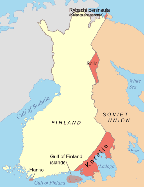
Finnish territory gained by the Soviet Union in the aftermath of the Winter War (dark red)

|
This military map image could be re-created using vector graphics as an SVG file. This has several advantages; see Commons:Media for cleanup for more information. If an SVG form of this image is available, please upload it and afterwards replace this template with
{{vector version available|new image name}}.
It is recommended to name the SVG file “Finnish areas ceded in 1940.svg”—then the template Vector version available (or Vva) does not need the new image name parameter. |
Xülasə[redaktə]
| İzah |
[]
Čeština: Mapa finsko-ruské hranice po Moskevském míru. Deutsch: Karte der Gebiete, die nach dem Winterkrieg 1940 von Finnland an die Sowjetunion abgetreten wurden. Eesti: Moskva rahulepinguga Talvesõja järel Nõukogude Liidule läinud alad. English: Map of the areas ceded by Finland to the Soviet Union after the Winter War 1940. Français : Territoires cédés par la Finlande à la Russie en 1940, après la Guerre d'Hiver. Italiano: Mappa delle rettifiche territoriali subite dalla Finlandia a favore dell'Unione Sovietica dopo la Guerra d'inverno (1940). Magyar: A kép a Téli háborút lezáró Moszkvai béke alapján Finnországtól a Szovjetuniónak átadott területeket mutatja Suomi: Suomen Moskovan rauhassa vuonna 1940 menettämät alueet. Русский: Карта территорий, переданных Финляндией Советскому Союзу после Зимней войны 1940 года. 中文: 冬季戰爭後芬蘭割給蘇聯的領土 العربية : الأراضي التي تنازلت فنلندا عنها بموجب معاهدة موسكو للسلام التي أنهت حرب الشتاء |
||||||||
| Tarix | |||||||||
| Mənbə | Öz işi | ||||||||
| Müəllif | Jniemenmaa | ||||||||
| İcazə (Faylın təkrar istifadəsi) |
I, the copyright holder of this work, hereby publish it under the following licenses:
İstədiyiniz lisenziyanı seçə bilərsiniz. |
||||||||
| Digər versiyalar |
[]
|


.png)


Faylın tarixçəsi
Faylın əvvəlki versiyasını görmək üçün gün/tarix bölməsindəki tarixlərə klikləyin.
| Tarix/Vaxt | Kiçik şəkil | Ölçülər | İstifadəçi | Şərh | |
|---|---|---|---|---|---|
| indiki | 19:44, 14 iyun 2015 | | 619 × 800 (26 KB) | RokerHRO (müzakirə | töhfələr) | optipng -o7 -i0 → 61.16% decrease |
| 09:48, 7 iyun 2015 |  | 619 × 800 (68 KB) | Hohum (müzakirə | töhfələr) | Clearer colours | |
| 13:45, 2 fevral 2015 |  | 619 × 800 (31 KB) | RokerHRO (müzakirə | töhfələr) | optipng -o7 -i0 → 41.00% decrease | |
| 07:18, 10 sentyabr 2005 |  | 619 × 800 (52 KB) | Jniemenmaa (müzakirə | töhfələr) | Map of Finnish areas ceded to the Soviet Union in 1940, after the Winter War. Category:Finland |
Siz bu faylı yenidən yükləyə bilməzsiniz.
Fayl keçidləri
Aşağıdakı 30 səhifə bu faylı istifadə edir:
- Atlas of Finland
- Atlas of colonialism
- User:MKFI/Military of Finland/2015 February 1-9
- User:MKFI/Military of Finland/2015 June 1-10
- User:MKFI/Military of Finland/2015 June 11-20
- User:Magog the Ogre/Maps of conflicts/2015 February
- User:Magog the Ogre/Maps of conflicts/2015 June
- File:Bellum Hiemale 1.PNG
- File:Elcsatolt finn területek1940.png
- File:Finnische abgetretene Gebiete 1940.png
- File:Finnische abgetretene Gebiete 1944.png
- File:Finnish areas ceded in 1940-IT.png
- File:Finnish areas ceded in 1940-ar.jpg
- File:Finnish areas ceded in 1940-es.svg
- File:Finnish areas ceded in 1940.png
- File:Finnish areas ceded in 1940 RUS.png
- File:Finnish areas ceded in 1940 RUS (1).png
- File:Finnish areas ceded in 1940 UKR.png
- File:Finnish areas ceded in 1944-ar.png
- File:Finnish areas ceded in 1944.png
- File:Moskevský mír.png
- File:Moskovan rauha-et.png
- File:Moskovan rauha.png
- File:Pariisin rauha.png
- File:Pariisin rauha de.png
- File:Pařížský mír.png
- File:Territoires finlandais cédés en 1940.png
- File:Territoires finlandais cédés en 1944.png
- Template:Other versions/Finnish cessiations to the Soviet Union
- Category:Moscow Peace Treaty
Faylın qlobal istifadəsi
Bu fayl aşağıdakı vikilərdə istifadə olunur:
- an.wikipedia.org layihəsində istifadəsi
- ast.wikipedia.org layihəsində istifadəsi
- az.wikipedia.org layihəsində istifadəsi
- be-tarask.wikipedia.org layihəsində istifadəsi
- be.wikipedia.org layihəsində istifadəsi
- bg.wikipedia.org layihəsində istifadəsi
- ca.wikipedia.org layihəsində istifadəsi
- da.wikipedia.org layihəsində istifadəsi
- de.wikipedia.org layihəsində istifadəsi
- el.wikipedia.org layihəsində istifadəsi
- en.wikipedia.org layihəsində istifadəsi
- en.wikibooks.org layihəsində istifadəsi
- en.wiktionary.org layihəsində istifadəsi
- eo.wikipedia.org layihəsində istifadəsi
- eu.wikipedia.org layihəsində istifadəsi
- fa.wikipedia.org layihəsində istifadəsi
- fr.wikipedia.org layihəsində istifadəsi
- fy.wikipedia.org layihəsində istifadəsi
- gl.wikipedia.org layihəsində istifadəsi
- hr.wikipedia.org layihəsində istifadəsi
- hu.wikipedia.org layihəsində istifadəsi
- id.wikipedia.org layihəsində istifadəsi
- it.wikipedia.org layihəsində istifadəsi
- ja.wikipedia.org layihəsində istifadəsi
- ko.wikipedia.org layihəsində istifadəsi
- lv.wikipedia.org layihəsində istifadəsi
- nl.wikipedia.org layihəsində istifadəsi
- nn.wikipedia.org layihəsində istifadəsi
- no.wikipedia.org layihəsində istifadəsi
- pl.wikipedia.org layihəsində istifadəsi
- pt.wikipedia.org layihəsində istifadəsi
Bu faylın qlobal istifadəsinə baxın.