File:Fires in India (MODIS 2020-10-28).jpg

Original file (6,152 × 5,050 pixels, file size: 3.66 MB, MIME type: image/jpeg)
Captions
Captions
Summary
[edit].jpg&action=edit§ion=1)
| Description |
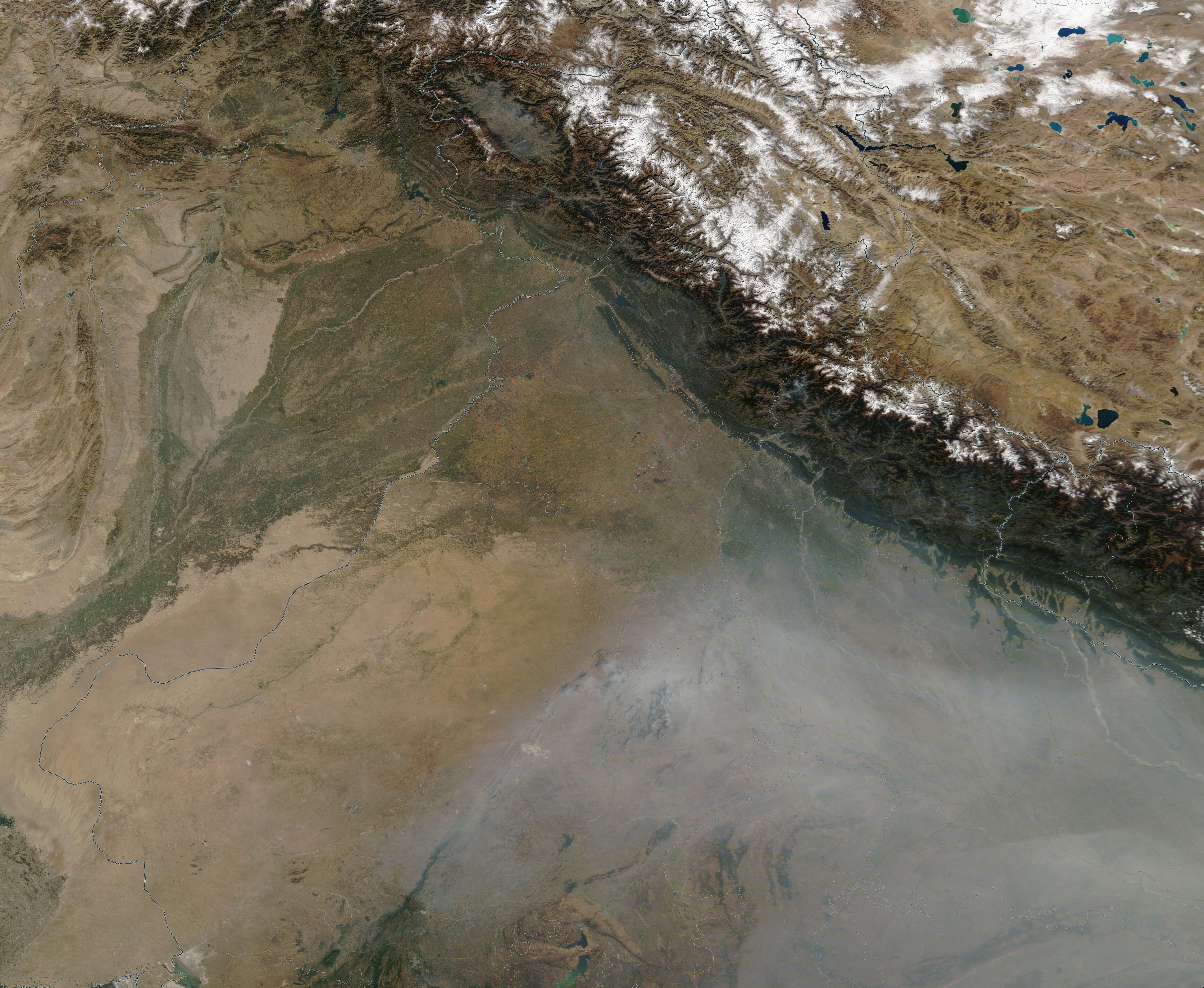
English: On October 27, 2020, the Moderate Resolution Imaging Spectroradiometer (MODIS) on board NASA’s Terra satellite acquired a true-color image of dozens of fires burning in the state of Punjab, India. Punjab, which lies in northwestern India adjacent to Pakistan, lies in a fertile alluvial plain that is also rich in water resources. With these assets, agriculture is vital to Punjab’s economy. The state produces two-thirds of India’s annual wheat production, leading to the nickname “India’s breadbasket”.
Fire is a widely used tool for land management in traditional agricultures. Farmers use fire for many purposes, including to clear the old crops from a field, to prepare land for planting new crops, to open land for agricultural purposes, and to renew pasture. In Punjab in the autumn, fire is frequently used to burn stubble from older crops. Because widespread use of fire creates smoke which increases air pollution across Northern India, stubble burning has been banned in much of India. However, when farmers do not have the needed, expensive farm equipment to rid their farms of organic debris, they often turn to fire. In this image, dozens of red “hot spots” can be seen in the green fields at the foot of the Himalaya Mountains and east of the pale gray line that represent the border between Pakistan and India. Each of these red dots mark areas where the thermal bands on the MODIS instrument has detected high temperatures. When combined with typical smoke, as in this image, such hot spots mark actively burning fire. While it is not possible to determine the cause of a fire from satellite imagery, the widespread nature, the location, and the time of year strongly suggests these are primarily agricultural fires. As typical for stubble fires in this region, the smoke blows to the south and east, thickening into a layer across the valleys south of the Himalayas. |
||
| Date | Taken on 27 October 2020 | ||
| Source |
|
||
| Author | MODIS Land Rapid Response Team, NASA GSFC |
| This media is a product of the Terra mission Credit and attribution belongs to the mission team, if not already specified in the "author" row |
Licensing
[edit].jpg&action=edit§ion=2)
| This file is in the public domain in the United States because it was solely created by NASA. NASA copyright policy states that "NASA material is not protected by copyright unless noted". (See Template:PD-USGov, NASA copyright policy page or JPL Image Use Policy.) | ||
 |
Warnings:
|
File history
Click on a date/time to view the file as it appeared at that time.
| Date/Time | Thumbnail | Dimensions | User | Comment | |
|---|---|---|---|---|---|
| current | 22:58, 6 February 2024 | | 6,152 × 5,050 (3.66 MB) | OptimusPrimeBot (talk | contribs) | #Spacemedia - Upload of http://modis.gsfc.nasa.gov/gallery/images/image10282020_250m.jpg via Commons:Spacemedia |
You cannot overwrite this file.
File usage on Commons
There are no pages that use this file.
.jpg&oldid=909384357)