File:Fires in Pakistan and India (MODIS 2019-10-20).jpg
Jump to navigation
Jump to search

Size of this preview: 745 × 600 pixels. Other resolutions: 298 × 240 pixels | 597 × 480 pixels | 954 × 768 pixels | 1,273 × 1,024 pixels | 2,545 × 2,048 pixels | 5,449 × 4,385 pixels.
Original file (5,449 × 4,385 pixels, file size: 2.58 MB, MIME type: image/jpeg)
Captions
Captions
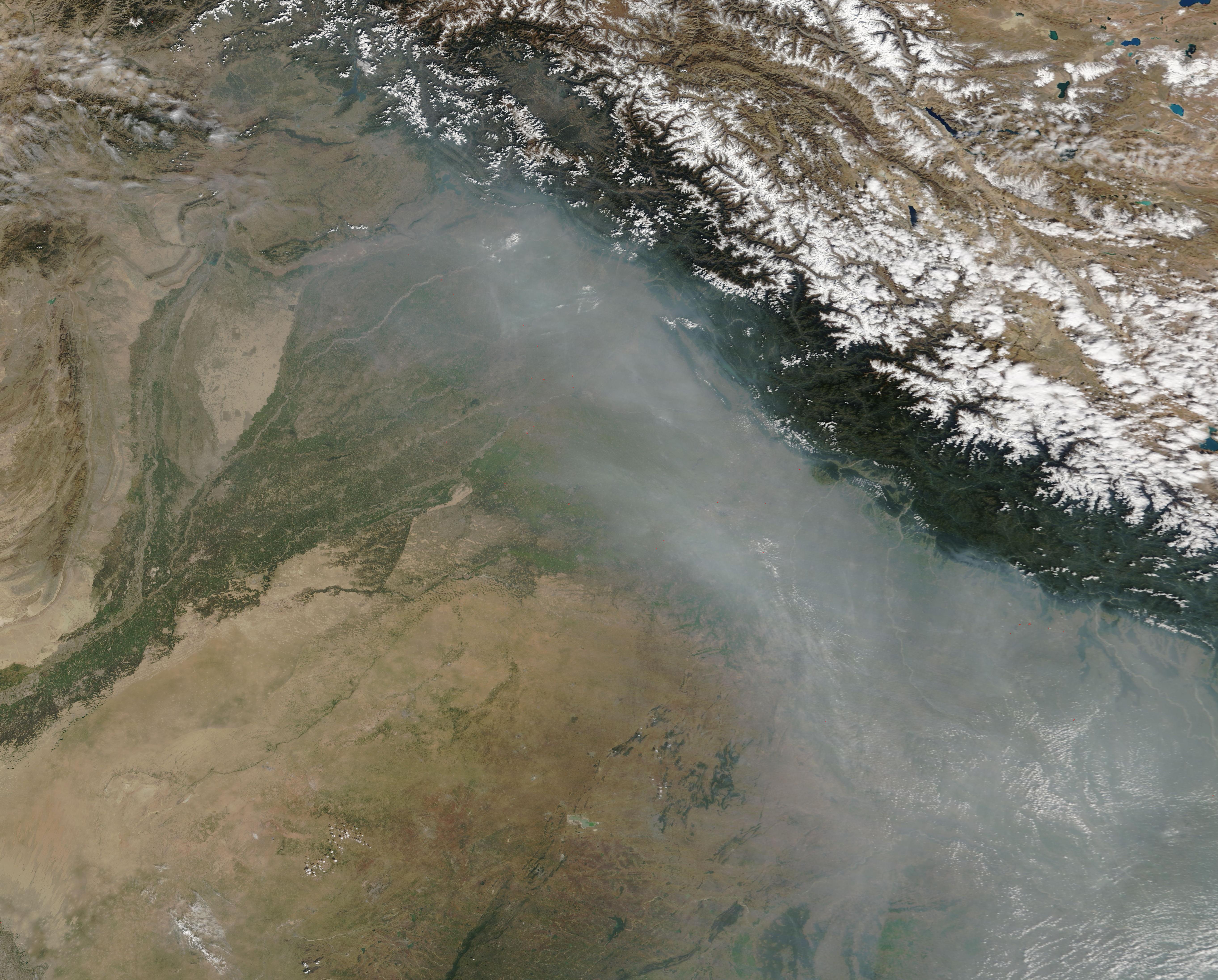
A thick layer of smoke lay over northeast Pakistan and northwestern India on October 16, 2019, when the Moderate Resolution Imaging Spectroradiometer (MODIS) on board NASA’s Terra satellite acquired a true-color image of the scene.
Summary[edit]
.jpg&action=edit§ion=1)
| Description |
English: A thick layer of smoke lay over northeast Pakistan and northwestern India on October 16, 2019, when the Moderate Resolution Imaging Spectroradiometer (MODIS) on board NASA’s Terra satellite acquired a true-color image of the scene. Dozens of red “hot spots” punctuate the smoky haze, each marking an area where the thermal bands on the instrument detected high temperatures. When combined with typical smoke, as in this image, such hot spots mark actively burning fire. The location, widespread nature, and time of year suggest these fires are agricultural in nature, deliberately set by farmers to manage land for crops or pasture.
There are two main growing seasons in this region and mid-October falls between the end of the first (kharif) and the start of the second (rabi). For the kharif, crops are planted as the rains begin in May through July and are harvest as the monsoon season comes to an end in September through October. The winter cropping season (rabi) begins quickly, with crops planted from October to December and harvested by February through April. In the traditional agriculture of the region, fire can be used to burn stubble at the end of each growing season and to prepare fields prior to planting. |
||
| Date | Taken on 16 October 2019 | ||
| Source |
Fires in Pakistan and India (direct link)
|
||
| Author | MODIS Land Rapid Response Team, NASA GSFC |
| This media is a product of the Terra mission Credit and attribution belongs to the mission team, if not already specified in the "author" row |
Licensing[edit]
.jpg&action=edit§ion=2)
| This file is in the public domain in the United States because it was solely created by NASA. NASA copyright policy states that "NASA material is not protected by copyright unless noted". (See Template:PD-USGov, NASA copyright policy page or JPL Image Use Policy.) | ||
 |
Warnings:
|
File history
Click on a date/time to view the file as it appeared at that time.
| Date/Time | Thumbnail | Dimensions | User | Comment | |
|---|---|---|---|---|---|
| current | 02:58, 17 February 2024 | | 5,449 × 4,385 (2.58 MB) | OptimusPrimeBot (talk | contribs) | #Spacemedia - Upload of http://modis.gsfc.nasa.gov/gallery/images/image10202019_250m.jpg via Commons:Spacemedia |
You cannot overwrite this file.
File usage on Commons
There are no pages that use this file.
.jpg&oldid=852734914)